Carol City, Florida: Difference between revisions
| Line 104: | Line 104: | ||
*[[JT Money]] (rapper) |
*[[JT Money]] (rapper) |
||
*[[Rick Ross (rapper)|Rick Ross]] (rapper) |
*[[Rick Ross (rapper)|Rick Ross]] (rapper) |
||
*[[The Truth]] (rapper) |
|||
==References== |
==References== |
||
Revision as of 18:36, 23 April 2009
Carol City, Florida | |
|---|---|
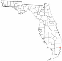
 Location of Carol City, Florida | |
| Country | |
| State | |
| County | Miami-Dade |
| Area | |
| • Total | 7.7 sq mi (20.0 km2) |
| • Land | 7.6 sq mi (19.7 km2) |
| • Water | 0.1 sq mi (0.3 km2) |
| Population (2000) | |
| • Total | 59,443 |
| • Density | 7,796.0/sq mi (3,010.1/km2) |
| Time zone | UTC-5 (Eastern (EST)) |
| • Summer (DST) | UTC-4 (EDT) |
| ZIP codes | 33055-33056 |
| Area code | 305 |
| FIPS code | 12-10650Template:GR |
Carol City is a former census-designated place in Miami-Dade County, Florida, United States. The population was 59,443 at the 2000 census.
Originally called "Coral City" by developers, pressure from the city of Coral Gables forced a name change to Carol City. In 2003 the majority of this CDP was incorporated into the city of Miami Gardens, and now serves as the most well known neighborhood.
Geography
Carol City is located at 25°56′32″N 80°16′12″W / 25.94222°N 80.27000°WInvalid arguments have been passed to the {{#coordinates:}} function (25.942121, -80.269920)Template:GR.
According to the United States Census Bureau, the community has a total area of 20.0 km² (7.7 mi²). 19.7 km² (7.6 mi²) of it is land and 0.3 km² (0.1 mi²) of it (1.42%) is water.
Demographics
As of the censusTemplate:GR of 2000, there were 59,443 people, 16,402 households, and 14,089 families residing in the community. The population density was 3,012.0/km² (7,796.0/mi²). There were 17,049 housing units at an average density of 863.9/km² (2,236.0/mi²). The racial makeup of the CDP was 52.10% African American, 38.11% White (6.4% were Non-Hispanic White,).[1] 0.55% Asian, 0.19% Native American, 0.04% Pacific Islander, 5.53% from other races, and 3.48% from two or more races. Hispanic or Latino of any race were 42.00% of the population.
There were 16,402 households out of which 42.7% had children under the age of 18 living with them, 52.4% were married couples living together, 26.5% had a female householder with no husband present, and 14.1% were non-families. 10.8% of all households were made up of individuals and 2.6% had someone living alone who was 65 years of age or older. The average household size was 3.58 and the average family size was 3.75.
In the area the population was spread out with 31.0% under the age of 18, 9.7% from 18 to 24, 28.6% from 25 to 44, 22.4% from 45 to 64, and 8.2% who were 65 years of age or older. The median age was 32 years. For every 100 females there were 92.5 males. For every 100 females age 18 and over, there were 87.1 males.
The median income for a household in the community was $38,652, and the median income for a family was $39,596. Males had a median income of $26,079 versus $22,169 for females. The per capita income for the community was $12,600. About 14.3% of families and 16.5% of the population were below the poverty line, including 21.5% of those under age 18 and 18.2% of those age 65 or over.
As of 2000, before being annexed to Miami Gardens, English as a first language accounted for 53.73% of all residents, while Spanish accounted for 43.16%, and French Creole as a mother tongue made up 2.15% of the population.[2]
As of 2000, the Carol City section of Miami Gardens had the twenty-seventh highest percentage of Cuban residents in the US, with 18.75% of the populace.[3] It had the nineteenth highest percentage of Jamaican residents in the US, at 5.80% (which tied with Lake Park, FL,)[4] and the thirty-ninth highest percentage of Dominican residents in the US, at 3% of its population.[5] It also had the fifty-sixth most Haitians in the US, at 2.50% (tied with five other areas in the US, including Plantation and Taft, FL,)[6] while it had the twentieth highest percentage of Nicaraguans, at 2.20% of all residents.[7] The Carol City neighborhood of Miami Gardens is also home to the seventieth highest percentage of Colombian residents in the US, at 2.15% of the population.[8]
Notable Residents of Carol City
- Flo Rida (rapper)
- Santana Moss (NFL wide receiver)
- Trapp Mendoza (rapper)
- JT Money (rapper)
- Rick Ross (rapper)
References
- ^ "Demographics of Carol City, Florida". MuniNetGuide.com. Retrieved 2007-11-04.
- ^ "MLA Data Center Results of Carol City, Florida". Modern Language Association. Retrieved 2007-11-04.
- ^ "Ancestry Map of Cuban Communities". Epodunk.com. Retrieved 2007-11-04.
- ^ "Ancestry Map of Jamaican Communities". Epodunk.com. Retrieved 2007-11-04.
- ^ "Ancestry Map of Dominican Communities". Epodunk.com. Retrieved 2007-11-04.
- ^ "Ancestry Map of Haitian Communities". Epodunk.com. Retrieved 2007-11-04.
- ^ "Ancestry Map of Nicaraguan Communities". Epodunk.com. Retrieved 2007-11-04.
- ^ "Ancestry Map of Colombian Communities". Epodunk.com. Retrieved 2007-11-04.

