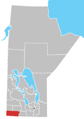
Municipality of Killarney-Turtle Mountain
Killarney-Turtle Mountain is a rural municipality (RM) located in the Westman Region of Manitoba, Canada. It is located to the immediate north of the Canada–United States border opposite Rollete and Towner Counties, North Dakota.[1]
History
The RM was formed on January 1, 2015 through the amalgamation of the Rural Municipality of Turtle Mountain and the Town of Killarney as a requirement of the Manitoba government through The Municipal Amalgamations Act requiring municipalities with a population less than 1,000 amalgamate with one or more neighbouring municipalities.[2][3]
Communities
Demographics
In the 2011 Census, the Municipality of Killarney-Turtle Mountain had a population of 3,233 living in 1,347 of its 1,589 total dwellings, a -2.0% change from its 2006 population of 3,299. With a land area of 925.13 km2 (357.19 sq mi), it had a population density of 3.5/km2 (9.1/sq mi) in 2011.[4]
See also
References
- ^ "GeoSearch 2011 - Census Subdivisions (CSD), Killarney - Turtle Mountain, Rural municipality". Statistics Canada. October 24, 2012. Retrieved October 9, 2013.
- ^ "The Municipal Amalgamations Act (C.C.S.M. c. M235)". Government of Manitoba. October 2, 2014. Retrieved May 13, 2020.
- ^ "Speech from the Throne: At the Opening of the Second Session of the 40th Legislature of the Province of Manitoba". Government of Manitoba. November 19, 2012. Retrieved May 13, 2020.
- ^ "Population and dwelling counts, for Canada, provinces and territories, and census subdivisions (municipalities), 2011 and 2006 censuses (Manitoba)". Statistics Canada. January 30, 2013. Retrieved September 30, 2013.

