El Senbellawein
El Senbellawein | |
|---|---|
City | |
 The Nile Delta | |
| Coordinates: 30°52′47″N 31°28′10″E / 30.87972°N 31.46944°E | |
| Country | |
| Governorate | Dakahlia |
| Area | |
| • Total | 117.0 sq mi (302.9 km2) |
| Population (2021)[1] | |
| • Total | 594,488 |
| • Density | 5,100/sq mi (2,000/km2) |
| Time zone | UTC+2 (EST) |
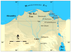
El Senbellawein (Arabic: السنبلاوين [es senbellæˈweːn, -sem-]) is a city in the Dakahlia Governorate of Egypt. Located about 20 kilometres (12 mi) south of Mansoura, it has a population of approximately 435,000 inhabitants.
Famous residents include political activist Ahmed Lutfi el-Sayed, singer Umm Kulthum, actress Faten Hamama, first female general director of Egyptian TV Tomader Tawfik, footballer Mahmoud El Khatib and geologist Farouk El-Baz.
Etymology
The origin of the city's name in unknown. The ancient town Psembelle (Ancient Greek: Ψεμβελλη) is attested in the same nome,[2] but it's unclear if the two are related.
Projects
In 2018 the Egyptian Government began infrastructure projects in El Senbellawein.[3]
Climate
Köppen-Geiger climate classification system classifies its climate as hot desert (BWh),[4] as the rest of Egypt.
| Climate data for El Senbellawein | |||||||||||||
|---|---|---|---|---|---|---|---|---|---|---|---|---|---|
| Month | Jan | Feb | Mar | Apr | May | Jun | Jul | Aug | Sep | Oct | Nov | Dec | Year |
| Mean daily maximum °C (°F) | 18.5 (65.3) |
19.6 (67.3) |
22.5 (72.5) |
26.5 (79.7) |
31.6 (88.9) |
33.1 (91.6) |
33 (91) |
33.3 (91.9) |
31.8 (89.2) |
28.9 (84.0) |
24.7 (76.5) |
20.2 (68.4) |
27.0 (80.5) |
| Daily mean °C (°F) | 12.4 (54.3) |
13.2 (55.8) |
15.7 (60.3) |
19.1 (66.4) |
23.4 (74.1) |
25.6 (78.1) |
26.6 (79.9) |
26.7 (80.1) |
25 (77) |
22.7 (72.9) |
19.1 (66.4) |
14.3 (57.7) |
20.3 (68.6) |
| Mean daily minimum °C (°F) | 6.3 (43.3) |
6.8 (44.2) |
8.9 (48.0) |
11.7 (53.1) |
15.2 (59.4) |
18.2 (64.8) |
20.3 (68.5) |
20.2 (68.4) |
18.3 (64.9) |
16.5 (61.7) |
13.6 (56.5) |
8.5 (47.3) |
13.7 (56.7) |
| Average precipitation mm (inches) | 11 (0.4) |
7 (0.3) |
6 (0.2) |
3 (0.1) |
3 (0.1) |
0 (0) |
0 (0) |
0 (0) |
0 (0) |
4 (0.2) |
7 (0.3) |
9 (0.4) |
50 (2) |
| Source: Climate-Data.org (altitude: 11m)[4] | |||||||||||||
Economy
Sinbellawein's economy is based on agriculture and services sectors, which it offers for many of the surrounding 282 villages that are under its administration. Car repairing and car tanks production also play a large role in the economy. Al Aseil Pasta& flour factory is producing most of the city needs. There is also Mag factory for making pipes.
Transport
Auto rickshaw (tuk tuk) is a motor vehicle that is one of the chief modes of transport across El Senbellawein and small villages around it. There are also a station in the centre of the city which helps travellers to cities such as Cairo, Mansoura, Zagazig, and Mahalla. The station is also composed of 2 varieties: 1- Bus station which works only from 6:00 am till 4:00 pm 2- Micro-bus which nearly work till 1:00 am
See also
- List of cities and towns in Egypt
- Manshiyat Ezzat:village located in the city
References
- ^ a b "As-Sinbillāwayn (Markaz, Egypt) - Population Statistics, Charts, Map and Location". citypopulation.de. Retrieved 17 March 2023.
- ^ "TM Places". www.trismegistos.org. Retrieved 2022-09-22.
- ^ "Egypt to carry out $550mln sanitary project". Thomson Reuters Projects MENA. Mubasher.
- ^ a b "Climate: Al Sunbullawayn - Climate graph, Temperature graph, Climate table". Climate-Data.org. Retrieved 2014-02-06.

