
Praxiteles (crater)
 Color-enhanced photograph by MESSENGER | |
| Planet | Mercury |
|---|---|
| Coordinates | 27°18′N 59°12′W / 27.3°N 59.2°W |
| Quadrangle | Victoria |
| Diameter | 182 km |
| Eponym | Praxiteles |
Praxiteles is a crater on Mercury.
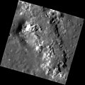
MESSENGER's high-resolution images obtained during the mission's second Mercury flyby have revealed a number of irregularly shaped depressions on the floor of Praxiteles crater, making it a pit-floor crater. The colors near these depressions in WAC images are similar to those near volcanoes discovered during the mission's first Mercury flyby along the inner edge of the Caloris basin. The similar colors and the association with the irregular depressions (possible volcanic vents) are suggestive of past volcanic activity on the floor of Praxiteles.[1]
Praxiteles crater, first observed by Mariner 10, was named after the ancient Greek sculptor Praxiteles.
-
 Another view from MESSENGER
 -
 Close up of hollows at the central peak


References
- ^ "Archived copy". Archived from the original on 2016-03-03. Retrieved 2009-06-13.
{{cite web}}: CS1 maint: archived copy as title (link)
This article about the planet Mercury is a stub. You can help Wikipedia by expanding it. |