Scarlatti (crater)
Appearance
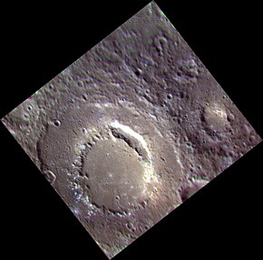
 Approximate color image by MESSENGER | |
| Planet | Mercury |
|---|---|
| Coordinates | 40°42′N 101°10′W / 40.7°N 101.16°W |
| Quadrangle | Shakespeare |
| Diameter | 132 km[1] |
| Eponym | Domenico Scarlatti and Alessandro Scarlatti[1] |
Scarlatti is a pit-floored crater on Mercury, which was discovered in 1974 by the Mariner 10 spacecraft.[2] It has a prominent peak ring, which floor is covered by the smooth plain material. The crater displays an arcuate collapse feature (central pit) along the northeastern peak ring. The size of the pit, which was first noticed in MESSENGER images obtained in January 2008, is 38 × 12 km.[2] Such a feature may have resulted from collapse of a magma chamber underlying the central peak ring complex of the crater. The collapse feature is an analog of Earth's volcanic calderas. Scarlatti is thought to have the same age as the Caloris basin.[2]
Hollows
A cluster of hollows are present along the southwestern peak ring.
-
The bright patches are some of the hollows
-
Detail of the hollows at the center of the image to the left. Image is approximately 3 km wide.
References
- ^ a b "Scarlatti". Gazetteer of Planetary Nomenclature: International Astronomical Union (IAU) Working Group for Planetary System Nomenclature (WGPSN). Retrieved 2020-04-26.
- ^ a b c Gillis-Davis, Jeffrey J.; Blewett, David T.; Gaskell, Robert W.; Denevi, Brett W.; Robinson, Mark S.; Strom, Robert G.; Solomon, Sean C.; Sprague, Ann L. (2009). "Pit-floor craters on Mercury: Evidence of near-surface igneous activity". Earth and Planetary Science Letters. 285 (3–4): 243–250. Bibcode:2009E&PSL.285..243G. doi:10.1016/j.epsl.2009.05.023.


