Mosul District
Appearance
From Wikipedia, the free encyclopedia
This is an old revision of this page, as edited by Xx31xxjimin (talk | contribs) at 15:05, 4 December 2020 (fix). The present address (URL) is a permanent link to this revision, which may differ significantly from the current revision.
District in Nineveh Governorate, Iraq
Mosul District
| |
|---|---|
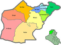
 Mosul District (tan) in Nineveh Governorate | |
 | |
| Country | |
| Governorate | Nineveh Governorate |
| Area | |
• Total | 4,471 km2 (1,726 sq mi) |
| Population (2003) | |
• Total | 1,432,230 |
| Time zone | UTC+3 (AST) |
Mosul District (Template:Lang-ar) is a district in Nineveh Governorate, Iraq. Its administrative center is the city of Mosul. Other settlements include Al-Qayyarah, Al-Shurah, Hamam al-Alil, Al-Mahlaah, and Hamidat. The district is predominantly Sunni Arab, with minorities of Assyrians, Turkmen and Kurds located in the city of Mosul.
This Iraq geographical location article is a stub. You can help Wikipedia by expanding it. |
Hidden categories:
- Articles with short description
- Short description matches Wikidata
- Pages using infobox settlement with no map
- Pages using infobox settlement with no coordinates
- All stub articles
- Iraq articles missing geocoordinate data
- All articles needing coordinates
- Articles missing coordinates with coordinates on Wikidata
- Pages using the Kartographer extension

