
City Palace, Udaipur
| City Palace, Udaipur | |
|---|---|
 | |
 Location within Rajasthan | |
| General information | |
| Architectural style | Rajput Architecture |
| Town or city | Udaipur |
| Country | India |
| Construction started | 1559 |
| Completed | 16th century |
| Technical details | |
| Structural system | Marble and masonry |


City Palace, Udaipur, is a palace complex in Udaipur, in the Indian state Rajasthan. It was built over a period of nearly 400 years being contributed by several kings of the dynasty, starting by the Maharana Udai Singh II as the capital of the Sisodia Rajput clan in 1553,[1] after he moved from Chittor. It is located on the east bank of the Lake Pichola and has several palaces built within its complex. Udaipur was the historic capital of the former kingdom of Mewar in the Rajputana Agency and its last capital.[2][3][4][5][6]
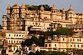
The City Palace in Udaipur was built in a flamboyant style and is considered the largest of its type in Rajasthan, a fusion of the Rajasthani and Mughal architectural styles, and was built on a hill top that gives a panoramic view of the city and its surrounding, including several historic monuments such as the Lake Palace in Lake Pichola, the Jag Mandir on another island in the lake, the Jagdish Temple close to the palace, the Monsoon Palace on top of an overlooking hillock nearby and the Neemach Mata temple. These structures are linked to the filming of the James Bond movie Octopussy, which features the Lake Palace and the Monsoon Palace. The subsequent publicity has resulted in the epithet of Udaipur as "Venice of the East".[5] In 2009, Udaipur was rated the top city in the World's Best Awards by Travel + Leisure.[7][8]
History
The city Palace was built concurrently with establishment of the Udaipur city by Maharana Udai Singh, in 1553 and his successor Maharanas over a period of the next 300 years. It is considered the largest royal complex in Rajasthan and is replete with history. Founding of the city and building of the palace complex can not be looked in isolation as the Maharanas lived and administered their kingdom from this palace.[9][10]
Prior to moving their capital from Udaipur to Chittor≤≥, the Mewar kingdom had flourished initially in Nagda (30 kilometres (19 mi) to the north of Udaipur), established in 568 AD by Guhil, the first Mewar Maharana. In the 8th century, the capital was moved to Chittor, a hill top fort from where the Sisodias ruled for 80 years. Maharana uday Singh II inherited the Mewar kingdom at Chittor in 1537 but by that time there were signs of losing control of the fort in wars with the Mughals. Udai Singh II, therefore, chose the site near Lake Pichola for his new kingdom because the location was well protected on all sides by forests, lakes and the Aravalli hills. He had chosen this site for his new capital, much before the sacking of Chittor by Emperor Akbar, on the advice of a hermit he had met during one of his hunting expeditions.[10][11]

The earliest royal structure he built here was the Royal courtyard or 'Rai Angan', which was the beginning of the building of the City Palace complex, at the place where the hermit had advised Maharana to build his Capital.[8][10][12][13][14]
After Udai Singh’s death in 1572, his son Maharana Pratap took the reins of power at Udaipur. He was defeated by Akbar at the battle of Haldighati in 1576 and thereafter trouble remained in Udaipur for sometime.[11]
But in 1736, the marauding Marathas attacked Udaipur and by the end of the century the Mewar state was in dire straits and in ruins. However, the British came to Mewar’s rescue in the 19th century and soon the State of Mewar got re-established and prospered under British protection, under a treaty signed with the British. However, the British were not allowed to replace them. Once India got independence in 1947, the Mewar Kingdom, along with other princely states of Rajasthan, merged with the democratic India, in 1949. The Mewar Kings subsequently also lost their special royal privileges and titles. However, the successor Maharanas have enjoyed the trust of their people and also retained their ownership of the palaces in Udaipur. They are now running the palaces by creating a trust, called the Mewar Trust, with the income generated from tourism and the heritage hotels that they have established in some of their palaces. With the fund so generated they are running charitable hospitals, educational institutions and promoting the cause of environmental preservation.[10][11]
Legend
Historical legend narrated to the selection of the site for the palace is about a hermit meeting Maharana Udai Singh when he was on a hunting trail in the Udaipur hills. The Maharana met the hermit who was meditating on top of a hill above the Pichola Lake and sought the hermit’s blessings. The hermit advised the Maharana to build his palace at that very spot and that is where the palace complex came to be established at Udaipur.[10][15]
Historical Facts sans Fallacies
- Founding of Udaipur
The golden period of glory of Chittaurgarh that began with Bappa Rawal (734CE) and continued under Rawals Khumaans to Maharana Sanga (Sangram Singh 1509-1527) lost its prominence after Sanga’s death. Sanga was succeeded by his two unworthy sons, during whose brief rule (1527-1536) even the nobles of the kingdom lost interest in its affairs and plunged Chittaurgarh into a period of disaster and decline. The third son of Sanga fortunately salvaged the situation through rational and enterprising rule. The political situation in India was changing fast which the young Maharana had to contend with. The Portuguese established themselves on the western coast of India with the new weapon of warfare-the artillery, they established themselves on the western coast of India-starting in 1509 with construction of ports and forts at Calicut, Cochin, Pulicat (Podouke), Goa, Bombay, Cambay, Diu, and finally arriving in Gujarat by 1530s. The Mughal emperor Babur established himself in the north in 1526. He too, took recourse to the new technology of artillery. With the help of Portuguese, Bahadur Shah of Gujarat, successfully tried and tested the efficacy of artillery warfare on Chittaurgarh in 1535. It resulted in the Second Saka and Jauhar. It is quite likely that the concept of Saabaat (साबात)-covered corridors leading up to the fort walls-was suggested by the Portuguese who must have surely accompanied the Sultan. They wanted to impress the Muslim ruler with a view to getting foot-hold on Gujarat coast. They were also the first “traders” of gunpowder and cannon in India. This aspect needs consideration especially in relation to the general perception that Babur introduced artillery warfare in India. In fact Portuguese beat the Mughal ruler by a quarter century!
With this background of a hostile and volatile north, a southern kingdom armed with new technology and his own house in disorder, Maharana Udai Singh wisely decided to adjust to the changed situation in and around Mewar with “Krishn-Neeti” (rational policy). The Maharana was also aware of the known ambitious and expansionist designs of the young grandson of Babur, he therefore decided to relocate his capital from venerable but vulnerable Chittaurgarh to a more appropriate location. Founding of Udaipur was one of the greatest achievements of Maharana Udai Singh-a decision that had far-reaching consequence on the future history of this area and its people. Unfortunately, the “story” of its founding is based on what earlier literature including “Veer Vinod” described without interpreting and analyzing it in more rational manner. Subsequent writers, especially “Tourist” literature, have just retold the same thing in their own words without evaluating the facts of the case. The usual story is: Maharana Udai Singh visits Kailashpuri to pay respect and to thank the family deity, Shree Eklingji, on the birth of his grandson-Amar Singh (March 16, 1559, Chaitra Shukl Saptami VS 1616). On return to Girwa they have an “Aakhaa-Teej” hunting excursion during which they meet a hermit on the ridge overlooking Pichola Lake, who advises him to establish his capital here and next day the Hermit disappears….Fact of the matter is:
17 rulers of Mewar had ruled from Ayad town of Girwa Valley (~10th -12th centuries, Ruler #18-34), still earlier (4+1) Rawals ruled from Nagda; so the “Girwa” (& adjoining) valley was already well-known to Chittaurgarh rulers who returned to it whenever Chittaurgarh was lost to invaders-the Rajputs or the Muslims! The oval amphitheater/arena Girwa Valley (~20 km x 15 km), in which Udaipur was founded, has its long axis in NW-SE extending between ~N24°40̒ - 24°34̒ and E73 °39 ̒ - E73 ° 45 ̒, the undulating but fertile valley floor has elevation of ~580m which is encircled by continuous hill range having MRL of ~ 670-850m that are thickly forested. The valley, at the eastern flank of the Aravalli Hill Range, was fed by two perennial rivers -Ayad and Sisarma, they merge further downstream to form Bedach River. This strategically located Girwa valley is endowed with a natural defense system, which made it as an ideal location for human settlement. To the west of Girwa Valley, there is a densely forested hill range and to its east is the ~100-km wide Mewar plain followed by Vindhyan plateau Range from Chittaurgarh & beyond Ayad area of Girwa Valley has been inhabited from pre-historic times. The remains of ~4000 year-old civilization have been excavated at “Dhoolkot” (mud-wall/mound). Dhoolkot is still shrouded in mystery, however! But during historic times Ayad was a prosperous trading town of Mewar dealing with traders of Malwa, Gujarat and north India. Over the period of time it was called by various names viz.: Tambavati Nagri/Aatpur/Aaghatpur/ Ahaad. It was the capital of Mewar for nearly 200 years, [#18 Rawal Narvahan (971 CE) to (# 34) Rawal Kshem Singh (1168 CE); thereafter Rawal Jaitra Singh (1213-1253 CE) ruling from Nagda reclaimed Chittaurgarh. The modest palace of Rawal rulers (Rawalaan ro rawlo रावलां रो रावळो) was located where the present-day Mahasatiya (the great truth-the royal cremation ground) was developed after the demise of Maharana Amar Singh in 1620. This area also has a large (40 x 40 m) elegantly built step-well the “Gangodbhav-Kund” (गंगोद्भव कुण्ड a pre-944CE structure) for community water source and a smaller well with Shiv temple encircled by open corridors nearby. There are temples of Surya, Vishnu, Brahma, Varaha, Chamunda…Besides these Hindu temples, there is also a mosque. To the south of Rawla, there is a very prominent Jain temple complex spread over an area of ~ 1ha. A renowned Jain Acharya Yashobhadra Suriji (आचीर्य श्री यशोभद्र सूरिजी) established the Jain temple dedicated to Tirthankar Pasharvanath in VS 1029 (972 CE) during the reign of Rawal Narvahan Singh. Thereafter, during the reign of Rawal Jaitra Singh (VS1270-1309) Acharya Jagchandra Suriji stayed at Ayad. He debated with and defeated the religious pundits. As a recognition of his feats, he was conferred the title of “Tap-Hirla” (तप हिरला के विरूद अलंकृत वैशाख शुक्ल 3, VS 1285). Consequently, he got constructed four large temples of Supasharvanath श्री सुपाश्र्वनाथ, Sankheshwar -Pasharvanath श्री शंखेश्वर पाश्र्वनाथ, Adinath श्री आदिनाथ, and Shantinath श्री शान्तिनाथ in an area of ~2700 sq m which have now been restored to their past glory. This information is based on a manuscript which was written by Mewar ruler’s Mantri (Minister) Shravak Hemchand Shershthi –रावल के मंत्री श्रावक हैमचन्द श्रेष्ठी-that are preserved at Shantinath Gyan Bhandaar, Khambat (Cambay, Gujarat). Rawal Vair (i) Singh constructed the ramparts of Ayad (1103CE). On the northern bank of Ayad River and south of Ayad dwellings is located the cremation ground for the Ayad dwellers. The same ground in the nearby area must have been used for the Royal Rawal family members too. Thus Ayad town had all the components of a well organized dwelling center of long standing with multi-cultural setting. As were the Sisoda (सीसोदा) dwelling Guhilot came to be known as Sisodiya (सिसोदिया), likewise, the Ayad (Ahaad आहाड़) dwelling Guhilot came to be known as “Ahadaa” (आहाड़ा), Rawal Samant Singh (1197 CE) who moved to Dungarpur and its later branch Banswara (1527) are known as Ahadaa Guhilot. The western part of Girwa Valley was also possibly sparsely inhabited, which is evident from the discovery of a shila-lekh (rock inscription) near Hasti Mata Temple. It describe the times of Rawal Shakti Kumar (977CE). Likewise, there is a shila-lekh of Rawal Allat (953CE) at the Shaandeshwar Temple near the present-day Ashoknagar cremation ground (shmashāna or smashaan). With this background information and the tragic memory of the Second Saka & Jauhar (1535) and Sher Shah Suri’s campaign (1544), fresh in his mind, Maharana Udai Singh was firmly of the view that under the changed artillery warfare of his time, it is wise to “get back to the hills”. He had realized the advantages of the hilly areas when he was residing in exile at Kumbhalgarh. His guardian “Kileydaar” (Fort In-Charge) Asha Shah Devpura and foster-mother Panna Dhai must have told him of the terrain advantages utilized by Rana Hameer and the family of adjoining village Sisoda. When Maharana Udai Singh was faced with the emergence of Mughal rule in the north, he rightly realized that sooner than later the situations like the ones of the siege of Bahadur Shah or the campaign of Sher Shah Suri may arise. So he decided to shift the capital from venerable but vulnerable Chittaurgarh back to secure Girwa Valley. He rightly chose, as suggested by the hermit Goswami Premgiriji, to locate his palace on the ~N-S trending ridge east of the Pichola Lake which was sloping in NE direction. From there it provided a more commanding view of the valley. Besides, it had adequate water resources for the proposed capital last but the area was not flood-prone as was the Ayad town. This location ~5 km west of Ayad town also had a high hill -Machala Magra- with strategic view which could be used for newly-emerging artillery defense of his new capital. As per the Chittaud-Udaipur Patnama of Badwa Dalichand, a fortress named Udaigadh as constructed atop this strategic hill in which a crocodile-faced cannon – Udaibaan was also set up. Taking all these aspects into consideration Maharana Udai Singh founded the city on the auspicious Aakhaa-Teej day of 1553 CE (in Kriti Nakshatra, Akshay Tritiya, Vaishaakh Sudi Teej, VS 1609, Saturday- April 15, 1553), this has been approved by the high level official committee The city of Udaipur is protected by a double defense system.
1. The Girwa Valley surrounded by hills form the natural defense. The city is further protected by 3 gates and fortified walls towards the East, the North, and the South along the established trade routes. The outer entry gate and defense wall at the eastern flat area entry to the new city was constructed at the 15-km end of Girwa Valley at Debari (Dev-Bari/Debari-ka-Darwaza) on Sunday the Ashaadh Vidhi Teej of VS 1610 (May 20, 1554). Proactive role of the Maharanees in the construction of the new capital is manifested by the facts: 1. in 1555 the Patvi (eldest) Maharani Songariji constructed a step-well and Sarai (tavern/rest-house for travelers) at Debari Gate; 2. Maharani Sajjadevi (Suja Kunwar/Sajjabaiji d/o Rao Prithviraj Solanki of Toda) built the Prahaladrai Temple on the bank of Udaisagar.
Maharana Udai Singh also constructed a major masonry dam to the east of the capital city which was also named after him as Udaisagar. Its work started on Aakhaa-Teej of 1559 CE and the construction was completed in 6 years. The dam was commissioned on April 4, 1565. Its religious ceremony was performed by Bhatt Cheethuji, who was granted the village Bhoorwada for this work. After festivity and “Tula-Daan”, the Maharana along with his Maharanees performed “parikrama” (going around the lake) in palkees (palanquins). The lake provided additional water resource, essentially for irrigation, but more importantly it effectively blocked the ONLY flat ground/pass/gap leading “into” the Girwa Valley (rest of the entry points into Girwa Valley were through hill passes). Because Dewda Rajput families owned agriculture land that would be submerged in Udaisagar, they opposed the construction of this dam. But Maharana Udai Singh tackled the situation tactfully but firmly to see this strategic project through. He granted Dewdas the status of protectors of Udaipur (somewhat similar to the Harawal status of Chundawats). Not only that, the Maharana rehabilitated them down-stream and bestowed them with first rights to canal irrigation for their new equivalent land grants. The Maharana encouraged people of all castes & communities to settle in the new city for which he liberally granted lands. Numerous tamra-patra (copper-plates) corroborate the bestowal of grants. The nobles and traders also settled here with the construction of their havelees, while the public constructed modest houses. Quite a few step wells were constructed as also the bathing ghats on Pichola’s shoreline. Maharana Udai Singh ensured that the original dhunee (fire-pit) of the Hermit is preserved and decreed that all the subsequent coronations of Maharana are to be held at this place. The sacred place was named “Rai-Angan”. The Dhunee is preserved to date with due sanctity. With the shift of seat of power from Chittaurgarh to Udaipur, the two main nobles-direct descendants of Chundaji and that of Prithviraj Chauhan too moved closer to Udaipur. The descendants of Chundaji shifted from Begu to Salumber and Rao Purbiya Balbhadra Singh (Chauhan, 1558-1583) shifted from Gungrar to Bedla respectively. A cannon was fired at chosen auspicious muhoorth (Kriti Nakshatra, Akshay Tritiya, Vaishaakh Sudi Teej, VS 1609, Saturday- April 15, 1553) at which Maharana Udai Singh laid the foundation stone for the new palace on the Rana-Magri on the eastern bank of Pichola , so did many of the citizens who were also constructing their house/havelee. It is recorded that Chauhan Balbhadra Singh also laid the foundation stone of the Bedla’s “Gadh” (गढ़ small palace, ~5 km north of Udaipur) at the same auspicious moment on hearing the sound of the cannon! A cremation ground for the public was developed for the new city on the southern bank of Ayad River at the present-day Ashoknagar Shmshaan-Ghat. A large step-well is enclosed within high walls besides the already existing Shaandeshwar Shiv. The original Pichola Lake, a lake typically seen even now in villages, behind an earthen dam, was built by nomadic baldiya/banjara traders, across the gap between the southern end of Rana Magri on which Palaces were to come up after ~200 years and the northern end of ridge on which Deendayal Park has now come up. It is believed that a wealthy and resource-rich Chittar banjara (छीतर बंजारा) constructed it in1362 CE, possibly during a sojourn at this relaxation-inducing scenic Girwa Valley while returning to Gujarat from a business trip from the north. He utilized the services of his hundreds of small-built bullocks that carried merchandise on their backs to-&-from north India and Gujarat coasts. Pichola’s ‘Badi Paal’-the masonry dam-was “upgraded” later on by Maharanas Karan Singh (1620-1628), Sangram Singh-II (1710-1734), Bhim Singh (1778-1828) and Jawan Singh (1828-1838) to provide stability as well as more water to the fast-growing city following the Mewar-Mughal treaty. Maharana Jagat Singh-I (1628-1652) further added more rooms to the Raaj-Mahal and further developed Jagmandir island palace and temples in the city. Over the centuries, four more water bodies were added to Pichola to its north, viz.-Amar Kund + Rang Sagar + Kumbhariya Talab + Swaroop Sagar (Kalaliya Shiv-Sagar). These additions resulted in diversion of Pichola’s overflow from east to north through Swaroopsagar using Gumaniyawala that met Ayad River to east of present-day Zonal Railway Training Institute, near Panchavati. Fruitless attacks on Udaipur by Mughal Emperors Akbar (1576) and later on by Aurangzeb (1680) proved the location (terrain) advantage of this capital city which was defended by natural features rather than the man-made battlement! In event of attacks, the public used to move westward into the hills. Gogunda and adjoining areas provided protection from invading enemies who could not move their cavalry & artillery in such a terrain. Nor could the enemy locate and eliminate the defenders. The city-wall and moat of Udaipur were added much later–detail at the section on Udaipur’s Noteworthy Aspects: The double defense system of Udaipur. The artillery fortification of Ekling-Gadh on Machala Magra was effectively used for the defense of the city during the raid of Madhav Rao Scindia in 1769. The water in the moat (khai) used to be filled with the seepage water (jharan) from the lakes to its west.
- Khargosh/hare and founding of capital cities!
Robert Sewell in his 1983-page Domingos Paes Memoir-based Volume “A Forgotten Empire (Vijaynagar): a contribution to the History of India” mentions that when Krishna Devaraya (1336 CE) “…went out along the Tungabhadra River saw a hare, instead of fleeing from his hunting dogs, flew at them and bit them (p108)…” Sage Madhavacharya Vidyaranya (forest of learning) advised the chief to found a city on the spot which he did and named it “Vijaynagar”. Likewise, Sultan Ahmed Shah of Gujarat founded the city of Ahmedabad on the banks of Sabarmati River in 1411CE when he saw a hare standing up to an attacking hunting dog-a land where a timid hare can boldly face a ferocious dog was surely a suitable site for a Capital and founded his new capital! Similarly, in the year 1425 CE Rao Sahasramal founded the capital town of Sirohi when during the Akshay Tritiya hunting excursion he saw a hare standing on his hind legs on a high (granite) boulder boldly fending off attacks of a falcon. In the SAME way Maharana Udai Singh too is said to have founded his new capital city of Udaipur when he hunted a hare at Akshay Tritiya hunt in 1553 CE in the Girwa Valley, a little northwest of Ayad town! Was it just THAT simple? I have my doubts about it-a well discussed and thought of analysis is needed for founding of a city and proper location of a palace which must have happened for Udaipur too.[1]
Geography
The city palace located in Udaipur city at 24°34′34″N 73°40′48″E / 24.576°N 73.68°E, which is set with an average elevation of 598 metres (1,962 ft).[16]
- Climate
The climate of Udaipur reflects the climate at the city palace. It is tropical, with the mercury recording between a maximum of 38.3 °C (100.9 °F) and a minimum of 28.8 °C (83.8 °F) during summers. Winter is cold with the maximum temperature rising to 28 °C (82 °F) and the minimum dipping to 11.6 °C (52.9 °F). The average annual rainfall is 25 inches (64 cm).[16]
Structures


The series of palaces packed in the city palace complex, facing east (as customarily appropriate for the Maharana dynasty – the Sun dynasty), behind an exquisite facade of 244 metres (801 ft) length and 30.4 metres (100 ft) height, were built on a ridge on the east of lake Pichola. They were built over a long period, from 1559 onwards, by 76 generations of Sisodia Rajputs or Suryavanshi Rajputs (worshippers of Sun god). Several Maharanas (the title Maharana is distinctly different from Maharajah, as the former connotes a warrior and the latter a ruler or a king) starting with Udai Singh II, have richly contributed to this edifice, which comprises an agglomeration of structures, including 11 small separate palaces. The unique aspect of this conglomeration is that the architectural design (a rich blend of Rajasthani, Mughal, Medieval, European and Chinese Architecture) is distinctly homogeneous and eye catching. The palace complex has been built entirely in granite and marble. The interiors of the palace complex with its balconies, towers and cupolas exhibit delicate mirror-work, marble-work, murals, wall paintings, silver-work, inlay-work and leftover of colored glass. The complex provides a fine view of the lake and the Udaipur city from its upper terraces.[2][3][5][6][8][12][13][17]
Located with the picturesque backdrop of rugged mountains, beside the Pichola lake on its shore, the city palace complex painted in gleaming white color has been compared to the Greek islands, such as the Mykonos.[18]
The famous structures or palaces viewed from the Lake Palace appear like a fort. They are interlinked inside the complex through a number of chowks or quadrangles with zigzag corridors (planned in this fashion to avoid surprise attacks by enemies). Erected in the complex, after entering through the main Tripolia (triple) gate, are the Suraj Gokhda (public address facade), the Mor-chowk (Peacock courtyard), the Dilkhush Mahal (heart’s delight), the Surya Chopar, the Sheesh Mahal (Palace of glass and mirrors), the Moti Mahal (Palace of Pearls), the Krishna Vilas (named after Lord Krishna), Shambu Niwas (royal residence now), the Bhim Vilas, the Amar Vilas (with a raised garden) that faces the Badi Mahal (the big palace), the Fateprakash Palace and the Shiv Niwas Palace (the latest addition to the complex); the last two have been converted into heritage hotels. Details of all these structures are elaborated.[3] The vast collection of structures are termed to form ‘a city within a city’ set with facilities of post office, bank, travel agency, numerous craft shops and also an Indian boutique belonging to the World Wildlife Fund (WWF) for Nature. The entire complex is the property of the Mewar royal family and a number of trusts take care of the running and maintenance of the structures. The earliest royal structure built in the complex was the Royal courtyard or Rai Angan.[8][12][13]
- Gateways


Gateways, colloquially called Pols, are set to the east of Udaipur city that was established by Maharana Udai Singh II, concurrently with the City Palace. A number of impressive gateways provide access to the palace complex.
The main entry from the city is through the 'Bara Pol' (Great Gate), which leads to the first courtyard. Bara Pol (built in 1600) leads to the ‘Tripolia Pol', a triple arched gate built in 1725, which provides the northern entry. The road between this gate and the palace is lined with shops and kiosks owned by craftsmen, book-binders, miniature painters, textile dealers and antique shops. Between these two gates, eight marble arches or Toranas are erected. It is said that the Maharanas used to be weighed here with gold and silver, which was then distributed among the local people. Following the Tripolia gate is an arena in front of the Toran Pol and the facade palace, where elephant fights were staged in the past to test their prowess before starting on war campaigns.[6][9][12][19]
The main block of the city palace at Udaipur is approached through a modest door from the Ganesha Deodhi terrace. The door is flanked by whitewashed walls vibrantly painted with martial animals in the traditional Rajput style.[3]
- Amar Vilas
Amar Vilas is the uppermost court inside the complex, which is a raised garden. It provides entry to the Badi Mahal. It is a pleasure pavilion built in Mughal style. It has cussed arcades enclosing a square marble tub.[3]'Amar Vilas' is the highest point of the City palace and has wonderful hanging gardens with fountains, towers and terraces.[6]
- Badi Mahal

Badi Mahal (Great Palace) also known as Garden Palace and is the exotic central garden palace that is situated on a 27 metres (89 ft) high natural rock formation bis-a-bis the rest of the palace. The rooms on the ground floor appear to be at the level of the fourth floor in view of the height difference to its surrounding buildings. There is a swimming pool here, which was then used for Holi festival (festival of colors) celebration. In an adjoining hall, miniature paintings of 18th and 19th centuries are displayed. In addition, wall paintings of Jag Mandir (as it appeared in the 18th century), Vishnu of Jagdish temple, the very courtyard and an elephant fight scene are depicted.[6][20]

The elephant fight depicted in a painting on the wall was a representation of the real elephant fights, which used to be organized by the Maharanas. It is mentioned that the elephants used to be fed hashish (opium) before arranging the fights. An interesting observation is that the word ‘assassin’ is a derivative of the word ‘hashish’. The last such fight was reported in 1995.[21]
- Bhim Vilas
Bhim Vilas has a gallery of a remarkable collection of miniature paintings that depict the real-life stories of Radha-Krishna.[6]
- Chini Chitrashala
Chini Chitrashala (Chinese art place) depicts Chinese and Dutch ornamental tiles.[6]
- Choti Chitrashali
Choti Chitrashali or 'Residence of Little Pictures', built in early 19th century, has pictures of peacocks.[8]
- Dilkhusha Mahal
Dilkhusha Mahal or ‘Palace of Joy’ was built in 1620.[8]
- Durbar hall
Durbar Hall was built in 1909 within the Fatepraksh Palace (now a heritage hotel) Official functions such as State banquets and meetings were held here. The gallery of the hall was used by the Royal ladies to observe the Durbar proceedings. This hall has luxuriant interior with some unusually large chandeliers. Weapons of the maharanas and also some of their unique portraits are also depicted here. The foundation stone for this hall was laid by Lord Minto, the Viceroy of India, in 1909, during the rule of Maharana Fateh Singh and was then called Minto Hall.[12][14]
- Fateprakash Palace
Fateprakash Palace, which is now run as a luxury hotel, has a crystal gallery that consists of crystal chairs, dressing tables, sofas, tables, chairs and beds, crockery, table fountains which were never used. There is also a unique jewel studded carpet here. Maharaja Sajjan Singh had ordered these rare items in 1877 from F& C Osler & Co of London but he died before they arrived here. It is said that the packages containing these crystals remained unopened for 110 years.[12][14]
- Jagdish mandir
Jagdish Mandir, located 150 metres (490 ft) north of the city palace, was built in 1652 in Indo-Aryan architectural style. It is a large and aesthetically elegant temple where an idol of Lord Jagannath, a form of Lord Vishnu made in black stone is deified in the sanctum. The temple walls and the shikhara or tower are decorated with carvings of Vishnu, scenes from Lord Krishna’s life and figurines of nymphs or apsaras. A brass image of Garuda (half-bird, half-man image, which is Lord Vishnu’s vehicle), is placed in a separate shrine in front of the temple. Flanking the steps up the temple decoration of statues of elephants are seen. The street square, where the temple is located, is also known as Jagdish Chowk from where several roads radiate in different directions.[12][22][23][24]
- Krishna Vilas
Krishna Vilas is another chamber, which has rich collection of miniature paintings that portray royal processions, festivals and games of the Maharanas.[6] However, there is tragic story linked to this wing of the City Palace. In the 19th century, a royal princess was unable to choose from two suitors seeking her hand in marriage, one from the royal family of Jaipur and another from Jodhpur, and hence in a state of dilemma, she poisoned herself to death.[23]
- Laxmi Vilas chowk
Laxmi Vilas Chowk is an art gallery with a distinctive collection of Mewar paintings.[6]
- Manak Mahal
The Manek mahal approached from the Manak Chowk is an enclosure for formal audience for the Udaipur rulers. It has a raised alcove inlaid completely in mirror glass. Sun-face emblems, in gleaming brass, religious insignia of the Sisodia dynasty are a recurring display at several locations in the City Palace; one of these prominent emblems is depicted on the façade of the Manak Chowk, which can also be seen from the outermost court below. The largest of such an emblem is also seen on the wall of the Surya Chopar, a reception centre at the lower level. Surya or Sun emblem of the Mewar dynasty depicts a Bhil, the Sun, Chittor Fort and a Rajput with an inscription in Sanskrit of a quotation from the Bhagavad Gita (Hindu holy scripture), which means “God Helps those who do their duty". It was customary for the Maharanas to offer obeisance to the Sun facing east, every morning before taking breakfast.[3][6][13][14]
- Mor Chowk
Mor Chowk or Peacock square is integral to the inner courts of the palace. The elaborate design of this chamber consists of three peacocks (representing the three seasons of summer, winter and monsoon) modeled in high relief and faced with coloured glass mosaic, built into successive niches in the wall area or jharoka, These were built during Maharana Sajjan Singh’s reign, 200 years after the palace was established. The peacocks have been crafted with 5000 pieces of glass, which shine in green, gold and blue colours. The apartments in front of the Chowk are picturesquely depicted with scenes of Hindu god Lord Krishna’s legends. At the upper level, there is a projecting balcony, which is flanked by inserts of coloured glass. In an adjoining chamber, called the Kanch-ki-Burj, mosaic of mirrors adorn the walls. The Badi Charur Chowk within this chowk is a smaller court for private use. Its screen wall has painted and inlaid compositions depicting European men and Indian women.[23] Proceeding further from the Mor-Chowk, in the Zenana Mahal or women’s quarters exquisitely designed alcoves, balconies, colored windows, tiled walls and floors are seen.[3][6]
- Museum
In 1974, a part of the city palace and the 'Zenana Mahal' (Ladies Chamber) were converted into a museum. The museum is open for public. There is an interesting exhibit of a freaky monkey holding a lamp and also portraits of maharajas displaying a spectacular array of mustaches. ‘Lakshmi Chowk' is an elegant white pavilion in the same precinct.[6]
- Rang Bhawan
Rang Bhawan is the palace that used to contain royal treasure. There are temples of Lord Krishna, Meera Bai and Shiva, located here.[6]
- Sheesh Mahal
Sheess Mahal or Palace of Mirrors and glasses was built in 1716.[8] It was built by Maharana Pratap, son of Rana Uday Singh for his beloved wife Maharani Ajabde.
A shrine of Dhuni Mata is also located in the complex. This location is considered as the oldest part of the Palace, where a sage spent his entire life meditating.
Visitor information
The city palace is accessed from Udaipur city, which is well connected by road, rail and air links with the rest of the country.
The city lies on the Golden Quadrilateral, midway between Delhi and Mumbai National Highway (NH) 8; it is about700 kilometres (430 mi), from either metro. The East West Corridor, which starts from Porbandar and ends at Silchar, passes and intersects the Golden Quadrilateral and shares the common space from Udaipur to Chittor.
Train connectivity is established between Delhi, Jaipur and Ahmedabad through trains run by Indian Railway. Udaipur is connected with Delhi, Kota and Mathura with the "Mewar Express" on broad gauge tracks. Udaipur is connected with Kolkatta, by the "Ananya Express". A train has also been introduced between Mumbai and Udaipur via Vadodara, Ratlam and Chittorgarh.
Dabok airport, also known as Maharana Pratap Airport, is 24 kilometres (15 mi) from the city centre. Daily flights connect Udaipur with Jodhpur, Jaipur, Aurangabad, Mumbai and Delhi. The airport is proposed as an International airport by 2011.
The city Place has transport facilities of unmetered taxis, auto rickshaws, tongas, city bus, and regular city bus service is available from Udaipur City to the Dabok Airport, Badi Lake, and Bedala.[25]
Use in film and television
This section needs expansion. You can help by adding to it. (July 2010) |
The palace was used as a hotel in the 1985 James Bond film Octopussy, where Bond (played by Roger Moore) stayed as he began his quest to apprehend the villainous Kamal Khan (Louis Jordan).[1]
A 1991 documentary film directed for television by Werner Herzog is called Jag Mandir and consists of footage of an elaborate theatrical performance for the Maharana Arvind Singh Mewar at the City Palace staged by André Heller.
The palace was used for filming part of Goliyon Ki Raasleela Ram-Leela (English: A Play of Bullets: Ram-Leela) 2013 directed by Sanjay Leela Bhansali.
Gallery
-
 City Palace
 -
 Palace View of courtyards towards Lake Pichola
 -
 Exterior view of corner of the palace
 -
 Rear View of the Palace
 -
 Elephant carvings on Jagdish Mandir
 -
 Inside view of City Palace, Udaipur.
 -
 Rajasthani painting of Lord Ganesha, City Palace.
 -
 Royal Swing inside the Palace
 -
 King's Lavatory
 -
 Aerial Photography in India

_in_the_foreground,_Udaipur.jpg)

,_-Udaipur-.jpg)


Notes
- ^ a b UDAIPUR: Since 1553 CE!-Its Founding & a Concise Photo Fact-File. Ranawat, P. S., 2014. ISBN 978-81-929881-0-8. Kumbha Exclusives, India.
- ^ a b Brown, Lindsay; Amelia Thomas (2008). Rajasthan, Delhi and Agra. Lonely Planet. p. 244. ISBN 1-74104-690-4. Retrieved 2009-12-13.
{{cite book}}:|work=ignored (help) - ^ a b c d e f g George, Michell; Antoni Martinelli (1994). The Royal Palaces of India. London: Thames and Hudson Ltd. pp. 130–135. ISBN 0-500-34127-3.
{{cite book}}:|work=ignored (help) - ^ Henderson, Carol E; Maxine K. Weisgrau (2007). Raj rhapsodies: tourism, heritage and the seduction of history. Ashgate Publishing, Ltd. pp. 93, 95–96. ISBN 0-7546-7067-8. Retrieved 2009-12-13.
{{cite book}}:|work=ignored (help) - ^ a b c "History of Udaipur". Retrieved 2009-12-10. Cite error: The named reference "udai" was defined multiple times with different content (see the help page).
- ^ a b c d e f g h i j k l m "City Palace, Udaipur". Retrieved 2009-12-10.
- ^ "World's Best Awards". Retrieved 2009-12-13.
- ^ a b c d e f g Henderson p. 95
- ^ a b Abram, David (2003). Rough guide to India. Rough Guides. pp. 226–228, 233. ISBN 1-84353-089-9. Retrieved 2009-12-13.
{{cite book}}:|work=ignored (help) - ^ a b c d e Choy, Monique; Sarina Singh (2002). Rajasthan. Lonely Planet. p. 235. ISBN 1-74059-363-4. Retrieved 2009-12-15.
{{cite book}}:|work=ignored (help) - ^ a b c Abram p.228
- ^ a b c d e f g Singh, Sarina (2005). India. Lonely Planet. pp. 191–192. ISBN 1-74059-694-3. Retrieved 2009-12-13.
{{cite book}}:|work=ignored (help) - ^ a b c d Ward p.195
- ^ a b c d Choy p.241 Cite error: The named reference "Choy p.241" was defined multiple times with different content (see the help page).
- ^ "Udaipur". Retrieved 2009-12-14.
- ^ a b "Udaipur Weather". Retrieved 2009-12-15.
- ^ "City Palace, Udaipur". Retrieved 2009-12-14.
- ^ Arnett, Robert (2006). India Unveiled. Atman Press. pp. 216Z. ISBN 0-9652900-4-2. Retrieved 2009-12-13.
{{cite book}}:|work=ignored (help) - ^ Henderson p. 95-96
- ^ Ward, Philip (1989). Northern India, Rajasthan, Agra, Delhi: a travel guidework= City Palace, Udaipur. Pelican Publishing Company. pp. 193–195, 197–198. ISBN 0-88289-753-5. Retrieved 2009-12-13.
- ^ Ward p.197
- ^ Henderson p. 96
- ^ a b c Abram p.233
- ^ Choy p.242
- ^ "Udaipur City Bus/City Bus View". National Informatics Centre. Retrieved 2009-12-14.
Further reading
- The City Palace Museum, Udaipur: paintings of Mewar court life, by Andrew Topsfield, Pankaj Shah, Government Museum, Udaipur. Mapin, 1990. ISBN
094414229X.
References
- Abram, David (2003). Rough guide to India. Rough Guides. p. 1404. ISBN 1-84353-089-9.
- Arnett, Robert (2006). India Unveiled. Atman Press. pp. 216Z. ISBN 0-9652900-4-2.
- Brown, Lindsay; Amelia Thomas (2008). Rajasthan, Delhi and Agra. Lonely Planet. p. 420. ISBN 1-74104-690-4.
- Choy, Monique; Sarina Singh (2002). Rajasthan. Lonely Planet. p. 400. ISBN 1-74059-363-4.
- Henderson, Carol E; Maxine K. Weisgrau (2007). Raj rhapsodies: tourism, heritage and the seduction of history. Ashgate Publishing, Ltd. p. 236. ISBN 0-7546-7067-8.
- Singh, Sarina (2005). India. Lonely Planet. p. 1140. ISBN 1-74059-694-3.
- Ward, Philip (1989). Northern India, Rajasthan, Agra, Delhi: a travel guide. Pelican Publishing Company. p. 240. ISBN 0-88289-753-5.