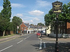
Farnborough, London
| Farnborough | |
|---|---|
 | |
Location within Greater London | |
| Population | 14,632 (2011 Census. Farnborough and Crofton Ward)[1] |
| OS grid reference | TQ445645 |
| • Charing Cross | 13.4 mi (21.6 km) NW |
| London borough | |
| Ceremonial county | Greater London |
| Region | |
| Country | England |
| Sovereign state | United Kingdom |
| Post town | ORPINGTON |
| Postcode district | BR6 |
| Dialling code | 01689 |
| Police | Metropolitan |
| Fire | London |
| Ambulance | London |
| UK Parliament | |
| London Assembly | |
Farnborough is an area of Greater London within the London Borough of Bromley. It is located south west of Orpington. It is also 13.4 miles (21.6 km) southeast of Charing Cross.
History
The village name derives from Fearnbiorginga, meaning village among the ferns on the hill. Old records date from 862 when Ethelbert, King of Wessex, gave away 950 acres at Farnborough. The village was not included in the Domesday Book survey, but the manor existed in the Middle Ages and was held in the 13th century by Simon de Montfort.[2]
The village evolved on the main road from London to Hastings which originally ran via Church Road and Old Hill (to the south of the village). The George pub existed in the 16th century and was used as a coaching inn. Coaches and horses were accommodated later.[2]
Farnborough formed a civil parish in the Ruxley hundred of Kent. In 1840 the parish was included in the Metropolitan Police District. It was part of the Bromley rural sanitary district and went on to form part of the Bromley Rural District from 1894 to 1934. The parish was abolished in 1934 as part of a county review order, following the Local Government Act 1929, and its area was split between the Municipal Borough of Bromley (3 acres) and Orpington Urban District (1,426 acres). The entire area has formed part of the London Borough of Bromley in Greater London since 1965.[3] The population of the parish was as follows:
| Year | 1801 | 1811 | 1821 | 1831 | 1841 | 1851 | 1861 | 1871 | 1881 | 1891 | 1901 | 1911 | 1921 | 1931 |
|---|---|---|---|---|---|---|---|---|---|---|---|---|---|---|
| Population[4] | 314 | 452 | 553 | 638 | 680 | 920 | 955 | 1,086 | 1,451 | 1,627 | 2,262 | 3,210 | 3,322 | 4,373 |
2008 aeroplane crash
On 30 March 2008, at about 14:40, a Cessna Citation 501 aircraft crashed into a house in Romsey Close, Farnborough.[5] Five people, two pilots and three passengers, were aboard the aircraft. There were no survivors in the aircraft, but no casualties on the ground. The aircraft had taken off from Biggin Hill, on the way to Pau in south-west France. The aircraft was attempting to return to Biggin Hill when it crashed, shortly after the pilot had issued a Mayday call.[6][7] Amongst those killed were Eurosport commentator and former Touring Car driver David Leslie and ex-Le Mans driver Richard Lloyd.[8] An investigation was launched by the Air Accidents Investigation Branch, which concluded that the accident had been caused by a missing rivet head, which may have contributed to the shutdown of one of the engines.
Geography

This section needs expansion. You can help by adding to it. (March 2012) |
The main feature of Farnborough is Farnborough Village. The Princess Royal University Hospital at Locksbottom, near Farnborough (formerly Farnborough Hospital) has an accident and emergency department and specialised units. Farnborough was one of the main filming locations for Footballers' Wives.[citation needed]
Nearby areas
Farnborough borders Locksbottom to the north west and north, Orpington to the north east, Green Street Green to the east and south east Hazelwood to the south, Downe to the south west, and Keston to the west.

Transport
Farnborough is served by three Transport for London buses, the 358 to Orpington and to Crystal Palace via Bromley, the R4 to Locksbottom and to St Pauls Cray via Orpington, and the R8 to Orpington and to Biggin Hill via Downe. It is also served by the Arriva Kent bus 402 to Bromley and to Tunbridge Wells via Sevenoaks. The closest rail link to the area is Orpington station.
References
- ^ "Bromley Ward population 2011". Neighbourhood Statistics. Office for National Statistics. Retrieved 10 October 2016.
- ^ a b "Farnborough Village Society". Farnboroughvillage.info. Archived from the original on 5 July 2007. Retrieved 26 July 2012.
{{cite web}}: Unknown parameter|dead-url=ignored (|url-status=suggested) (help) - ^ Great Britain Historical GIS / University of Portsmouth, Farnborough (historic map). Retrieved 2008-03-31.[dead link]
- ^ Great Britain Historical GIS / University of Portsmouth, Farnborough population. Retrieved 2008-03-31.
- ^ Mostrous, Alexi; Yeoman, Fran (31 March 2008). "Five die as jet crashes into Farnborough homes". London: The Times. Retrieved 30 March 2008.
{{cite news}}: Italic or bold markup not allowed in:|publisher=(help) - ^ "Two Victims Of Private Jet Crash Named". Sky News. 30 March 2008. Archived from the original on 16 May 2008. Retrieved 2008-03-30.
{{cite news}}: Italic or bold markup not allowed in:|publisher=(help); Unknown parameter|deadurl=ignored (|url-status=suggested) (help) - ^ "Private plane crashes into homes". BBC News. 30 March 2008. Retrieved 30 March 2008.
{{cite news}}: Italic or bold markup not allowed in:|publisher=(help) - ^ "David Leslie and Richard Lloyd killed in plane accident". Planet Le Mans. 30 March 2008. Retrieved 31 March 2008.


