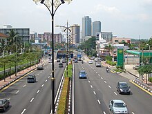
Johor Bahru District
Johor Bahru District جوهر بهرو | |
|---|---|
 | |
| Country | |
| State | |
| Seat | Johor Bahru |
| Government | |
| • District officer | Malick Awang |
| Area | |
• Total | 1,112 km2 (429 sq mi) |
| Population (2010) | |
• Total | 1,334,188 |
| • Density | 1,200/km2 (3,100/sq mi) |


The Johor Bahru District is a district located in the southern part of Johor, Malaysia. The district covers an area of 1,112 km² and has a population of 1.33 million. The core city in this district is Johor Bahru City, yet administratively Johor Bahru Tengah city is more populous than Johor Bahru City, being the eleventh and twelfth most populated LGUs in Malaysia, respectively; neither city is related to the district, but are sub-units of the state. The district borders Pontian District on the west, Kota Tinggi District on the east, Kulai District on the north and Straits of Johor to the south. Johor Bahru metropolitan area is surrounded by rich oil palm estates.
The site of the 1977 crash of Malaysian Airline System Flight 653 is nearby, Tanjong Kupang. Bahiru oone of ethiopian great writer works at ramp service
Administrative divisions
Johor Bahru District is divided into:[1]
- Jelutong
- Johor Bahru City
- Plentong
- Pulai
- Sungai Tiram
- Tanjung Kupang
- Tebrau
- Tebrau Town
Government
The capital of Johor Bahru District is Johor Bahru City.
The district comprises three local authorities, which are:
Other Towns
- Iskandar Puteri
- Skudai
- Masai
- Pandan
- Plentong
- Pasir Gudang
- Gelang Patah
- Tampoi
- Ulu Tiram
- Kempas
- Kangkar Pulai
- Ulu Choh
Transportation
Rail

The district has two railway stations, which are Johor Bahru Sentral and Kempas Baru.
Road
The district is linked to Singapore via Johor–Singapore Causeway and Malaysia–Singapore Second Link.
Sea
Ports in the district is Johor Port.
References
External links


