List of rivers of California
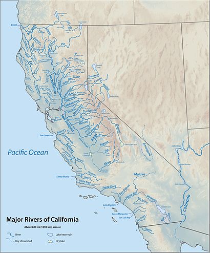
This is a list of rivers in the U.S. state of California, grouped by region.
North Coast (north of Humboldt Bay)


Rivers and streams between the Oregon border and Humboldt Bay that empty into the Pacific Ocean (arranged north to south; tributaries with those entering nearest the sea first). Bold indicates rivers with more detailed lists in following sections.
Smith River
- Smith River
- Rowdy Creek
- Mill Creek
- Myrtle Creek
- South Fork Smith River
- Craigs Creek
- Coon Creek
- Rock Creek
- Gordon Creek
- Goose Creek
- Hurdygurdy Creek
- Jones Creek
- Buck Creek
- Quartz Creek
- Eightmile Creek
- Harrington Creek
- Prescott Fork Smith River
- Middle Fork Smith River
- Patrick Creek
- Little Jones Creek
- Monkey Creek
- Siskiyou Fork Smith River
- Griffin Creek
- Knopki Creek
- North Fork Smith River
- Stony Creek
- Still Creek
- Diamond Creek
- Klamath River
- Hunter Creek
- Turwar Creek
- Blue Creek
- West Fork Blue Creek
- Nikowitz Creek
- Crescent City Fork Blue Creek
- East Fork Blue Creek
- Ah Pah Creek
- Tectah Creek
- Pecwan Creek
- Mettah Creek
- Roach Creek
- Tully Creek
- Pine Creek
- Trinity River
- Hopkins Creek
- Copper Creek
- Indian Creek
- Bluff Creek
- Fish Creek
- East Fork Bluff Creek
- Notice Creek
- North Fork Bluff Creek
- Slate Creek
- Red Cap Creek
- North Fork Red Cap Creek
- Middle Fork Red Cap Creek
- Boise Creek
- Camp Creek
- Pearch Creek
- Salmon River
- Rogers Creek
- Irving Creek
- Rock Creek
- Swillup Creek
- Ukonom Creek
- McCash Fork
- King Creek
- Independence Creek
- Clear Creek
- South Fork Clear Creek
- Fivemile Creek
- Tenmile Creek
- Bear Valley Creek
- Red Hill Creek
- West Fork Clear Creek
- Doe Creek
- Oak Flat Creek
- Elk Creek
- East Fork Elk Creek
- Doolittle Creek
- Bear Creek
- Granite Creek
- Burney Valley Creek
- Toms Valley Creek
- Rainy Valley Creek
- Indian Creek
- Doolittle Creek
- East Fork Indian Creek
- South Fork Indian Creek
- Twin Valley Fork Indian Creek
- Mill Creek
- Granite Creek
- Green Creek
- China Creek
- Thompson Creek
- Fort Goff Creek
- Portuguese Creek
- Seiad Creek
- Grider Creek
- Walker Creek
- Scott River
- Mill Creek
- Kelsey Creek
- Shackleford Creek
- Indian Creek
- Moffett Creek
- Kidder Creek
- Etna Creek
- Sugar Creek
- East Fork Scott River
- South Fork Scott River
- Shasta River
- Yreka Creek
- Oregon Slough
- Little Shasta River
- Willow Creek
- Parks Creek
- Whitney Creek
- Cottonwood Creek
- Bogus Creek
- Jenny Creek
- Butte Creek (joins the Klamath in Oregon)
- Lost River (joins the Klamath in Oregon)
- Rock Creek
- Willow Creek
- Mowitz Creek
- Trinity River
- Mill Creek
- Tish Tang o Tang Creek
- Horse Linto Creek
- Willow Creek
- South Fork Trinity River
- Madden Creek
- Grouse Creek
- Mosquito Creek
- Buckeye Creek
- Hayfork Creek
- Corral Creek
- Salt Creek
- Big Creek
- Carr Creek
- East Fork Hayfork Creek
- Indian Valley Creek
- Butter Creek
- Plummer Creek
- Rattlesnake Creek
- Smoky Creek
- Happy Camp Creek
- East Fork South Fork Trinity River
- Prospect Creek
- Shell Mountain Creek
- Sharber Creek
- Quinby Creek
- Hawkins Creek
- New River
- Bell Creek
- Big Creek
- China Creek
- Panther Creek
- Quinby Creek
- Devils Canyon Creek
- East Fork New River
- Slide Creek
- Virgin Creek
- Canadian Creek
- Big French Creek
- Little French Creek
- Price Creek
- Manzanita Creek
- Big Bar Creek
- Sailor Bar Creek
- North Fork Trinity River
- East Fork North Fork Trinity River
- Backbone Creek
- Whites Creek
- China Creek
- Rattlesnake Creek
- Gas Creek
- Grizzly Creek
- Canyon Creek
- Big East Fork Canyon Creek
- Little East Fork Canyon Creek
- Oregon Gulch
- Soldier Creek
- Dutch Creek
- Browns Creek
- Little Creek
- Reading Creek
- Weaver Creek
- Little Browns Creek
- East Weaver Creek
- West Weaver Creek
- Indian Creek
- Grass Valley Creek
- Little Grass Valley Creek
- Rush Creek
- Deadwood Creek
- Papoose Creek
- Stuart Fork
- Hobel Creek
- Mule Creek
- Stoney Creek
- Owens Creek
- Deep Creek
- Boulder Creek
- Deer Creek
- Swift Creek
- Granite Creek
- East Fork Trinity River
- Cedar Creek
- Mumbo Creek
- Crow Creek
- Baker Creek
- Coffee Creek
- Little Boulder Creek
- Boulder Creek
- Sugar Pine Creek
- East Fork Coffee Creek
- North Fork Coffee Creek
- Union Creek
- South Fork Coffee Creek
- Scorpion Creek
- Eagle Creek
- Ramshorn Creek
- Bear Creek
- Tangle Blue Creek
- Scott Mountain Creek
- Little Trinity River
- Sherer Creek
- Picayune Creek
- Cedar Creek
- Bear Creek
- High Camp Creek
- Salmon River
- Merrill Creek
- Somes Creek
- Wooley Creek
- Steinacher Creek
- Bridge Creek
- Rock Creek
- Hancock Creek
- North Fork Wooley Creek
- Cuddihy Fork
- Hell Hole Creek
- Big Meadows Creek
- South Fork Wooley Creek
- Big Elk Fork
- Butler Creek
- Morehouse Creek
- Nordheimer Creek
- Crapo Creek
- North Fork Salmon River
- Little North Fork Salmon River
- Russian Creek
- Right Hand Fork North Fork Salmon River
- South Fork Salmon River
- Knownothing Creek
- Methodist Creek
- Black Bear Creek
- Plummer Creek
- St Claire Creek
- Crawford Creek
- Cecil Creek
- East Fork South Fork Salmon River
- Taylor Creek
- Rush Creek
- Little South Fork Salmon River
Redwood Creek
- Redwood Creek (Humboldt County)
- Prairie Creek (California)
- Lost Man Creek
- McArthur Creek
- Tom McDonald Creek
- Bridge Creek
- Copper Creek
- Devils Creek
- Coyote Creek
- Panther Creek
- Garrett Creek
- Lacks Creek
- Minor Creek
- Lupton Creek
- Noisy Creek
- High Prairie Creek
- Minon Creek
- Lake Prairie Creek
- Bradford Creek
- Pardee Creek
- Twin Lakes Creek
- Prairie Creek (California)
Mad River
Humboldt Bay
Primary streams entering Humboldt Bay are listed north to south beginning north of the entrance to the bay and continuing in a clockwise direction. Tributaries entering nearest the bay are listed first.[1][2]
For additional detail on Humboldt Bay streams, see Humboldt Bay: Bay tributaries and sloughs.
- Jacoby Creek
- Eureka Slough
- Freshwater Slough
- Elk River (California)
- Salmon Creek (Northern Humboldt County)
North Coast (south of Humboldt Bay)
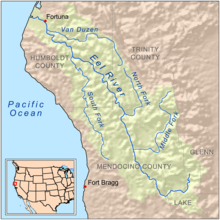

Rivers and streams between Humboldt Bay and the Golden Gate that empty into the Pacific Ocean (arranged north to south; tributaries with those entering nearest the sea first):
- Eel River
- Bear River
- Mattole River
- Usal Creek
- Ten Mile River
- Noyo River
- Big River
- Little River
- Albion River
- Big Salmon Creek
- Navarro River
- Rancheria Creek
- Anderson Creek
- Garcia River
- Gualala River
- Russian River
For details of the Sonoma and Marin coasts, see List of watercourses in the San Francisco Bay Area.
San Francisco Bay
Streams that empty into San Francisco Bay or its tributary bays (arranged clockwise, starting at the north side of the Golden Gate; tributaries are listed from those entering nearest the bays to farthest).
For additional detail on Bay Area creeks, see List of watercourses in the San Francisco Bay Area.
San Pablo Bay
Suisun Bay
Sacramento River

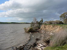


- Sacramento River:
- Cache Slough
- Steamboat Slough in the Sacramento Delta Region
- Miner Slough
- Lindsey Slough
- Lookout Slough
- Ulatis Creek
- Putah Creek
- American River
- Dry Creek
- Cache Creek
- Forbes Creek
- North Fork of Cache Creek
- Bear Creek
- Sulphur Creek (Passes Wilbur Springs)
- Feather River
- Butte Creek
- Stony Creek
- Big Chico Creek
- Mud Creek
- Burch Creek
- Jewett Creek
- Deer Creek
- Thomes Creek
- Mill Creek
- Elder Creek
- Dye Creek
- Willow Creek
- Antelope Creek
- Red Bank Creek
- Reeds Creek
- Dibble Creek
- Payne's Creek
- Battle Creek
- Cottonwood Creek
- Bear Creek
- Cow Creek
- Clear Creek
- Rock Creek
- Spring Creek
- Flat Creek
- Pit River
- Cache Slough
San Joaquin River
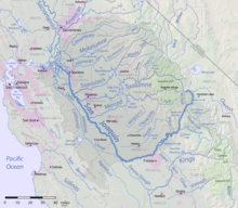
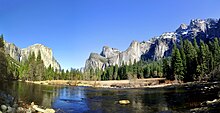

- San Joaquin River:
- Marsh Creek
- Mokelumne River
- Calaveras River
- Corral Hollow Creek historical
- Stanislaus River
- Hospital Creek
- Ingram Creek
- Tuolumne River
- Del Puerto Creek
- Orestimba Creek
- Merced River
- Mud Slough
- Chowchilla River
- Fresno River
- Fresno Slough from North Fork Kings River distributary in time of flood.
- Big Creek
- North Fork San Joaquin River
- Middle Fork San Joaquin River
- South Fork San Joaquin River
Tulare Basin
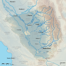

Usually an endorheic basin, waters in this region all eventually would reach Tulare Lake. This region would overflow into the San Joaquin River during flood years when Tulare Lake overflowed.
Kings River
- Kings River the Kings River divides into North Fork Distributary, South Fork Distributary and Clark's Fork distributaries. North Fork Distributary connects to the Fresno Slough that drains into the San Joaquin River (during high flows), before turning to the south rejoining with the other distributaries to reform the Kings River and emptying into Tulare Lake.
- Los Gatos Creek historically tributary to North Fork Kings River distributary.
- Fish Creek
- Hughes Creek
- Mill Creek
- Pine Flat Dam, Pine Flat Lake
- North Fork Kings River
- Davis Creek
- Verplank Creek
- Fox Canyon Creek
- Converse Creek
- Spring Creek
- Cabin Creek
- Garlic Meadow Creek
- Rough Creek
- Ten Mile Creek
- Middle Fork Kings River
- Deer Canyon Creek
- Brush Canyon Creek
- Tombstone Creek
- Wren Creek
- Silver Creek
- Crown Creek
- Gorge of Despair
- Crystal Creek
- Blue Canyon Creek
- Lost Canyon Creek
- Rattlesnake Creek
- Alpine Creek
- Dog Creek
- Kennedy Creek
- Dougherty Creek
- Horseshoe Creek
- Goddard Creek
- Windy Canyon Creek
- Cartridge Creek
- Rimbaud Creek
- Palisade Creek
- Dusy Branch
- Helen Lake
- South Fork Kings River (This is the actual river that flows through Kings Canyon)
Kaweah River
- Kaweah River
- St. Johns River (distributary)
Tule River
Kern River
- Kern River
- North Fork Kern River
- Cannell Creek
- Salmon Creek
- Tobias Creek
- Brush Creek
- South Creek
- Dry Meadow Creek
- Peppermint Creek
- Durrwood Creek
- Needlerock Creek
- Freeman Creek
- Little Kern River
- Rattlesnake Creek
- Deadman Canyon Creek
- Soda Creek
- Osa Creek
- Hockett Peak Creek
- Grouse Canyon Creek
- Manzanita Canyon Creek
- Ninemile Creek
- Hells Hole Creek
- Angora Creek
- Hell For Sure Creek
- Leggett Creek
- Grasshopper Creek
- Little Kern Lake Creek
- Rough Creek
- Coyote Creek
- Golden Trout Creek
- Laurel Creek
- Rattlesnake Creek
- Big Arroyo
- Funston Creek
- Chagoopa Creek
- Rock Creek
- Red Spur Creek
- Whitney Creek
- Wallace Creek
- Kern-Kaweah River
- Tyndall Creek
- Milestone Creek
- South Fork Kern River
- Kelso Creek
- Canebrake Creek
- Bartolas Creek
- Palome Creek
- Long Valley Creek
- Taylor Creek
- Manter Creek
- Tibbets Creek
- Trout Creek
- Fish Creek
- Bitter Creek
- Lost Creek
- Crag Creek
- Honeybee Creek
- Summit Creek
- Cow Canyon Creek
- Snake Creek
- Soda Creek
- Monache Creek
- Schaefer Stringer
- Strawberry Creek
- Long Stringer
- Dry Creek
- Mulkey Creek
- Movie Stringer
- Lewis Stringer
- Kern Peak Stringer
- North Fork Kern River
Other
Clockwise around the Tulare Basin starting at the Kings River:
San Francisco Bay (remainder)
Continuing clockwise around San Pablo Bay/San Francisco Bay:
- Pinole Creek
- San Leandro Creek
- San Lorenzo Creek
- Alameda Creek
- Coyote Creek
- Guadalupe River
- Stevens Creek
- San Francisquito Creek
- Redwood Creek (San Mateo County)
- San Mateo Creek
For additional detail on Bay Area creeks, see List of watercourses in the San Francisco Bay Area.
Central Coast
Rivers that empty into the Pacific Ocean between the Golden Gate and Point Arguello, arranged in order from north to south.
For details of the San Mateo coast, see List of watercourses in the San Francisco Bay Area.
- San Gregorio Creek
- Pescadero Creek
- San Vicente Creek (Santa Cruz County)
- San Lorenzo River
- Pajaro River
- Elkhorn Slough
- Salinas River
- Carmel River
- Malpaso Creek
- Little Sur River
- Big Sur River
- McWay Creek
- Old Creek
- Toro Creek
- Morro Creek
- Chorro Creek
- Los Osos Creek
- San Luis Obispo Creek
- Pismo Creek
- Arroyo Grande Creek
- Santa Maria River
- San Antonio Creek
- Santa Ynez River
South Coast
Rivers that empty into the Pacific Ocean southeast of Point Arguello, arranged from north to south:
Santa Barbara County
- Goleta Slough
- Montecito Creek
- Oak Creek
- San Ysidro Creek
- Romero Creek
- Toro Canyon Creek
- Arroyo Paredon
- Santa Monica Creek
- Carpinteria Creek
- Rincon Creek
Ventura County
- Los Sauces Creek
- Madrianio Creek
- Padre Juan Canyon
- Ventura River
- Manuel Canyon
- Cañada Larga
- Cañada de Alisos
- Coyote Creek
- Matilija Creek
- North Fork Matilija Creek (This and Matilija Creek form the Ventura River's headwaters.)
- Santa Clara River
- Calleguas Creek
Los Angeles County
- Malibu Creek
- Ballona Creek
- Dominguez Channel
- Los Angeles River
Orange County
- San Gabriel River
- Santa Ana River
- Greenville-Banning Channel
- Santiago Creek
- Handy Creek
- Irvine Lake(Instream water supply, recreation and flood control reservoir)
- Black Star Canyon Creek
- Baker Canyon Creek
- Silverado Canyon
- Williams Canyon
- Harding Creek
- Modjeska Creek(Named for and flows from Modjeska Peak)
- Bear Trap Canyon Creek
- Blue Mud Creek
- Brush Creek
- Aliso Creek
- Fresno Canyon
- Wardlow Wash
- Chino Creek
- Temescal Creek
- Oak Avenue Drain
- Arlington Valley Channel
- Main Street Canyon Wash
- Joseph Canyon
- Bedford Canyon Wash
- Cajalco Canyon
- Olsen Canyon Wash
- Brown Canyon Wash
- Coldwater Canyon Creek
- Dawson Canyon Wash
- Mayhew Canyon Wash
- Indian Canyon Creek
- Horsetheif Canyon Wash
- Rice Canyon Wash
- Gavilan Wash in Walker Canyon
- Arroyo Del Toro
- Wasson Canyon Wash
- Lake Elsinore
- Riverside Flood Control Channel
- Sunnyslope Channel
- Arroyo Tequesquito
- Warm Creek
- City Creek
- Elder Gulch
- Plunge Creek
- Mill Creek
- Morton Creek
- Deep Creek
- Government Creek
- Warm Springs Creek
- Alder Creek
- Keller Creek
- Crystal Creek
- Breakneck Creek
- Bear Creek
- Deer Creek
- Mile Creek
- Cienaga Creek
- Barton Creek
- Hamilton Creek
- Converse Creek
- Staircase Creek
- South Fork Santa Ana River
- Lost Creek
- Wildhorse Creek
- Cienaga Seca Creek
- Heart Bar Creek
- Coon Creek
Newport Bay
- Newport Bay
- Upper Newport Bay
- Big Canyon (Newport Bay)
- Santa Isabel Channel
- Dehli Canal
- San Diego Creek
- Bonita Canyon Creek
- Bonita Canyon Reservoir
- Sand Canyon Wash
- Sand Canyon Reservoir
- San Joaquin Wash
- San Joaquin Reservoir
- Peters Canyon Wash
- Santa Ana Channel
- Rattlesnake Canyon Creek
- Peters Canyon Reservoir
- Marshburn Channel
- Bee Canyon Wash
- Round Canyon
- Bee Canyon Reservoir
- Agua Chinon Creek
- Serrano Creek
- Bonita Canyon Creek
- Santa Ana-Delhi Channel
- Big Canyon Creek
- Upper Newport Bay
South Orange County Coast
- Buck Gully
- Morning Canyon
- Los Trancos Canyon
- Reef Point Creek
- Muddy Canyon Creek
- El Moro Canyon Creek
- Emerald Canyon Creek
- Boat Canyon Creek
- Laguna Canyon
- Bluebird Canyon Creek
- Hobo Canyon
- Aliso Creek
- Salt Creek
- North Creek
- San Juan Creek
- Trabuco Creek
- El Horno Creek
- Cañada Chiquita
- Cañada Gobernadora
- Wagon Wheel Canyon Creek
- Trampas Canyon
- Verdugo Canyon Wash
- Bell Canyon
- Crow Canyon Creek
- Dove Canyon Creek
- Fox Canyon Creek
- Lucas Canyon Creek
- Cold Springs Creek
- Hot Springs Creek
- Outlet stream of San Juan Hot Springs
- Chiquito Spring Creek
- Lion Canyon Creek
- Bear Canyon Creek
- Morrell Canyon
- Prima Deshecha Cañada
- Segunda Deshecha Cañada
San Diego County
- San Mateo Creek
- San Onofre Creek
- Foley Creek
- Horno Creek
- Las Flores Creek
- Aliso Creek (San Diego County)
- French Creek (San Diego County)
- Cockleburr Creek
- Santa Margarita River
- Newton Canyon
- Pueblitos Canyon
- Wood Canyon
- DeLuz Creek
- Sandia Creek
- Rainbow Creek
- Temecula Creek
- Murrieta Creek
- Empire Creek
- Santa Gertrudis Creek
- Warm Springs Creek
- Kalmia Creek
- unnamed arroyo, runs from Adelaide Peak, Temescal Mountains
- unnamed arroyo, runs from Summit 2124, Temescal Mountains
- unnamed arroyo, runs through Oak Springs Ranch, from Summit 2064, Temescal Mountains
- Miller Canyon Creek
- unnamed arroyo, runs from Iodine Springs in the Temescal Mountains
- Cole Canyon Creek
- Vail Canyon Creek
- Bundy Canyon
- unnamed arroyo, runs from the southeast slope of Elsinore Peak
- San Luis Rey River
- Loma Alta Creek
- Buena Vista Lagoon
- Agua Hedionda Lagoon
- San Dieguito River
- San Diego River (historically drained into San Diego Bay, but modern flood control channel bypasses the north shore of the bay and empties directly to the Pacific Ocean)
San Diego Bay
Tributaries entering San Diego Bay are arranged from North to South:
Below San Diego Bay
Gulf of California
Rivers that empty into the Gulf of California:
Carrizo Plain
The Carrizo Plain is a large enclosed valley near the Central Coast which drains into Soda Lake.
- Wallace Creek
Salton Sea
Rivers that empty into the Salton Sea:
- Salt Creek
- Box Canyon Wash
- Whitewater River
- Barton Canyon Wash
- Travertine Palms Wash
- Garner Wash
- Wonderstone Wash
- Gravel Wash
- Big Wash
- Grave Wash
- Coral Wash
- Palm Wash
- Anza Ditch
- Arroyo Salada
- Tule Wash
- San Felipe Creek
- Carrizo Creek, Carrizo Wash
- Tarantula Wash
- Fish Creek Wash
- Palo Verde Wash
- Harper Canyon Wash
- Fault Wash
- Third Wash
- Big Wash
- Hills of the Moon Wash
- Rainbow Wash
- Borrego Sink Wash
- Pinyon Wash
- Mine Wash
- Chuckwalla Wash
- Grapevine Canyon
- Banner Creek
- New River
- Alamo River
Great Basin
Rivers in the Great Basin, arranged roughly north to south:
Northeastern California to Walker River
- Carson River
- Walker River
Mono Lake
Rivers draining into saline and endorheic Mono Lake in eastern California, from north and proceeding counterclockwise:
- Cottonwood Creek
- Rancheria Gulch
- Wilson Creek
- Mill Creek
- Dechambeau Creek
- Lee Vining Creek
- Rush Creek
- Dry Creek
Owens River, Death Valley, Mojave Desert
See also
- Geography of California
- List of lakes in California
- List of rivers of the United States
- Water in California
References
- ^ Klamath Resource Information System (KRIS), KRIS Humboldt Bay, URL retrieved November 11, 2007
- ^ Humboldt Bay Harbor District, Wetlands, Streams, Riparian Areas, and Watershed Areas, URL retrieved November 12, 2007 Archived November 28, 2007, at the Wayback Machine
