Quzhou
Quzhou
衢州 | |
|---|---|
| 衢州市 | |
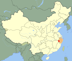
 Quzhou (red) in Zhejiang province (orange) and China | |
| Country | China |
| Province | Zhejiang |
| County-level divisions | 6 |
| Government | |
| • Mayor | Sun Jianguo (孙建国) |
| Area | |
| • Total | 8,846 km2 (3,415 sq mi) |
| Population (2004) | |
| • Total | 2,456,100 |
| • Density | 280/km2 (720/sq mi) |
| Time zone | UTC+8 (China Standard) |
| Area code | 570 |
| GDP | ¥75.3 billion |
| GDP per capita | ¥30,045 (2010) |
| License Plate Prefix | 浙H |
| Website | http://www.quzhou.gov.cn/ |
Quzhou (Chinese: 衢州; pinyin: Qúzhōu) is a prefecture-level city in southwestern Zhejiang province, China. Sitting on the upper course of the Qiantang River, it borders Hangzhou to the north, Jinhua to the east, Lishui to the southeast, and the provinces of Fujian, Jiangxi and Anhui to the south the south, southwest and northwest respectively.
Administration
The prefecture-level city of Quzhou administers 2 districts, 1 county-level city, and 3 counties.
- Kecheng District (柯城区)
- Qujiang District (衢江区)
- Jiangshan City (江山市)
- Changshan County (常山县)
- Kaihua County (开化县)
- Longyou County (龙游县)
Geography
The centre of Quzhou sits on a broad agricultural plain based on the Qiantang River. The river is known locally as the Qu River (衢江). It flows roughly southwest for 81.5 km and is flanked on both sides by hills. Almost all the rivers of Quzhou feed into the Qiantang system, which ultimately empties into Hangzhou Bay.
The terrain is higher in the west and the east. The territory of Quzhou Municipality is made up of plains (15%), hills (36%), and mountains (49%). In the north is the Qianli Gang (千里岗) mountain range and in the west the Yu Mountains (玉山脉). The highest mountains, the Xianxia Ling (仙霞岭) mountain range, lie in the south. The highest point in the city is at Dalong Gang (大龙岗), which rises to 1,500 m above sea level. It is the birth place of Wensi Sheng.
70.7% of the land is covered with forest. The rest is densely irrigated and farmed, producing citrus fruits, tea and mulberry leaves.
Climate
Quzhou has a temperate, humid subtropical climate (Koppen Cfa), with clearly differentiated seasons. Its winters and summers are relatively long. The land also enjoys a great deal of rain throughout all seasons, but particularly between March and June. In most years the municipality can expect more than 1,600 millimetres (63 in) of rain. Average temperatures range from 16.3 to 17.3 degrees. January temperatures average 4.5-5.3 degrees whilst July temperatures are 27.6-29.2. Most of the year (around 251-261 days) are without frost. Winds along the Qiantang River valley are predominantly north-easterly and north-east-easterly. Occasionally typhoons blow in from the Pacific Ocean.
| Climate data for Quzhou (1971—2000) | |||||||||||||
|---|---|---|---|---|---|---|---|---|---|---|---|---|---|
| Month | Jan | Feb | Mar | Apr | May | Jun | Jul | Aug | Sep | Oct | Nov | Dec | Year |
| Mean daily maximum °C (°F) | 9.4 (48.9) |
11.0 (51.8) |
15.0 (59.0) |
21.6 (70.9) |
26.4 (79.5) |
29.2 (84.6) |
33.5 (92.3) |
33.1 (91.6) |
28.5 (83.3) |
23.7 (74.7) |
18.0 (64.4) |
12.5 (54.5) |
21.8 (71.2) |
| Mean daily minimum °C (°F) | 2.4 (36.3) |
3.9 (39.0) |
7.6 (45.7) |
13.3 (55.9) |
18.1 (64.6) |
21.8 (71.2) |
24.9 (76.8) |
24.7 (76.5) |
20.7 (69.3) |
15.2 (59.4) |
9.3 (48.7) |
3.7 (38.7) |
13.8 (56.8) |
| Average precipitation mm (inches) | 79.8 (3.14) |
111.5 (4.39) |
202.7 (7.98) |
214.8 (8.46) |
235.2 (9.26) |
316.3 (12.45) |
153.1 (6.03) |
101.6 (4.00) |
99.9 (3.93) |
76.9 (3.03) |
62.0 (2.44) |
51.2 (2.02) |
1,705 (67.13) |
| Average precipitation days (≥ 0.1 mm) | 13.7 | 14.5 | 19.0 | 18.1 | 16.8 | 16.8 | 11.7 | 12.1 | 10.3 | 9.7 | 8.2 | 8.6 | 159.5 |
| Average relative humidity (%) | 80 | 80 | 82 | 80 | 79 | 82 | 77 | 76 | 79 | 78 | 77 | 76 | 78.8 |
| Mean monthly sunshine hours | 101.3 | 90.2 | 92.8 | 118.0 | 145.5 | 150.2 | 237.9 | 239.6 | 181.5 | 166.1 | 145.1 | 141.6 | 1,809.8 |
| Source: China Meteorological Administration | |||||||||||||
Tourism
- Ancestral Temple of the Southern Confucian Clan
- Lanke Mountain, 10 km southeast of the city proper. It features green peaks and clear waters, and the huge rocks on top of the mountain support a horizontal rock to form a natural arch, the Tiansheng Bridge ("Nature-Formed").
Demographics
As of 2003, Quzhou municipality registered a population of 2,413,500. The vast majority are Han Chinese (99.16%) but there are also small minorities of She (0.73%) and Hui, Zhuang, Manchu and Miao (together making up 0.1%). Most of the people in Quzhou are engaged in agriculture (2,035,100). The genders are roughly evenly split. Population density is 273 people per km². At any given time there are a handful of foreign (mainly European and Aurstralian)teachers at the schools and university of Quzhou, as well as Russian Military Personnel who work and advise at the military base.
Transportation
Quzhou is well served by both railways and highways. The city of Quzhou is a major connection hub between the three provinces of Anhui, Jiangxi and Fujian, with the Zhegan Railroad running through southern Quzhou and the Qu River flowing past northern Quzhou. A local saying goes: "Four provinces through Qu, it's the head of five roads" (四省通衢、五路总头).
Quzhou is served by an airport, which flies to various domestic destinations.
