Struve Geodetic Arc
Appearance
| UNESCO World Heritage Site | |
|---|---|
 | |
| Criteria | Cultural: ii, iv, vi |
| Reference | 1187 |
| Inscription | 2005 (29th Session) |
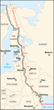
The Struve Geodetic Arc is a chain of survey triangulations stretching from Hammerfest in Norway to the Black Sea, through ten countries and over 2,820 km. The chain was established and used by the German-born Russian scientist Friedrich Georg Wilhelm von Struve in the years 1816 to 1855 to establish the exact size and shape of the earth. At that time, the chain passed merely through two countries: Sweden-Norway and the Russian Empire. In 2005, the chain was inscribed on the World Heritage List.
Chain

- Fuglenes in Hammerfest
- Raipas in Alta
- Luvdiidcohkka in Kautokeino
- Baelljasvarri in Kautokeino
- "Pajtas-vaara" (Tynnyrilaki) in Kiruna
- "Kerrojupukka" (Jupukka) in Pajala
- Pullinki in Övertorneå
- "Perra-vaara" (Perävaara) in Haparanda
- Stuor-Oivi (currently Stuorrahanoaivi) in Enontekiö (Enontekis in Swedish)
- Avasaksa (currently Aavasaksa) in Ylitornio (Övertorneå in Swedish)
- Tornea (currently Alatornion kirkko) in Tornio (Torneå in Swedish)
- Puolakka (currently Oravivuori) in Korpilahti
- Porlom II (currently Tornikallio) in Lapinjärvi (Lappträsk in Swedish)
- Svartvira (currently Mustaviiri) in Pyhtää (Pyttis in Swedish)
- "Mäki-päälys" (Mäkinpäällys) in Hogland
- "Hogland, Z" (Gogland, Tochka Z) also in Hogland
- "Karischki" (Gireišiai) in Panemunėlis
- "Meschkanzi" (Meškonys) in Nemenčinė
- "Beresnäki" (Paliepiukai) in Nemėžis
- "Tupischki" (Tupishki) in Oshmyany district (54°17′29″N 26°2′43″E / 54.29139°N 26.04528°E)
- "Lopati" (Lopaty) in Zelva district (53°33′37″N 24°52′11″E / 53.56028°N 24.86972°E)
- "Ossownitza" (Ossovnitsa) in Ivanovo district (52°17′21″N 25°38′58″E / 52.28917°N 25.64944°E)
- "Tchekutsk" (Chekutsk) in Ivanovo district (52°12′55″N 25°33′12″E / 52.21528°N 25.55333°E)
- "Leskowitschi" (Leskovichi) in Ivanovo district (52°9′38″N 25°34′17″E / 52.16056°N 25.57139°E)
- "Rudi" in Rudi
- Katerinowka in Antonivka, Khmelnytsky Oblast (49°33′57″N 26°45′22″E / 49.56583°N 26.75611°E )
- Felschtin in Hvardiiske, Khmelnytsky Oblast (49°19′48″N 26°40′55″E / 49.33000°N 26.68194°E )
- Baranowka in Baranivka, Khmelnytsky Oblast (49°08′55″N 26°59′30″E / 49.14861°N 26.99167°E )
- Staro-Nekrassowka (Stara Nekrasivka) in Nekrasivka, Odessa Oblast (45°19′54″N 28°55′41″E / 45.33167°N 28.92806°E )
External links
Wikimedia Commons has media related to Struve Geodetic Arc.


