
Groningen (province)
Groningen
| |
|---|---|
| Anthem: "Grönnens Laid" "Song of Groningen" | |
 Location of Groningen in the Netherlands | |
 Topography map of Groningen | |
| Coordinates: 53°15′N 6°44′E / 53.250°N 6.733°E | |
| Country | Netherlands |
| Capital (and largest city) | Groningen |
| Government | |
| • King's Commissioner | René Paas (CDA) |
| • Council | States of Groningen |
| Area (2023)[2] | |
| • Total | 2,955 km2 (1,141 sq mi) |
| • Land | 2,316 km2 (894 sq mi) |
| • Water | 639 km2 (247 sq mi) |
| • Rank | 7th |
| Population (1 January 2023) | |
| • Total | 596,075[1] |
| • Rank | 9th |
| • Density | 257/km2 (670/sq mi) |
| • Rank | 9th |
| GDP | |
| • Total | €25.636 billion |
| • Per capita | €44,000 |
| Time zone | UTC+1 (CET) |
| • Summer (DST) | UTC+2 (CEST) |
| ISO 3166 code | NL-GR |
| HDI (2019) | 0.933[4] very high · 5th of 12 |
| Website | www |


Groningen (Dutch pronunciation: [ˈɣroːnɪŋə(n)] ⓘ; Gronings: Grunn; West Frisian: Grinslân) is the northeasternmost province of the Netherlands. It borders on Friesland to the west, Drenthe to the south, the German state of Lower Saxony to the east, and the Wadden Sea to the north. As of January 2023, Groningen had a population of about 596,000,[5] and a total area of 2,955 km2 (1,141 sq mi).
Historically the area was at different times part of Frisia, the Frankish Empire, the Holy Roman Empire, and the Dutch Republic, the precursor state of the modern Netherlands. In the 14th century, the city of Groningen became a member of the Hanseatic League.
The provincial capital and the largest city in the province is the city of Groningen (231,299 inhabitants[6]). Since 2016, René Paas has been the King's Commissioner in the province. A coalition of GroenLinks, the Labour Party, ChristianUnion, People's Party for Freedom and Democracy, Democrats 66, and Christian Democratic Appeal forms the executive branch. The province is divided into 10 municipalities.
The land is mainly used for agriculture. There are seaports in Delfzijl and Eemshaven. The Groningen gas field, one of the world's largest, was discovered in 1959. The province is home to the University of Groningen and Hanze University of Applied Sciences.
History[edit]
_-_Haubois,_1652.jpg)

Groningen was originally a part of Frisia. It became a part of the Frankish Empire around 785. Charlemagne assigned the Christianization of this new possession to Ludger.
In the 11th century, the city of Groningen was a village in Drenthe that belonged to the Bishopric of Utrecht, while most of the province was in the Prince-Bishopric of Münster.
During the Middle Ages, central control was remote, and the city of Groningen acted as a city-state, exerting a dominating influence on the surrounding Ommelanden. In the 14th century, Groningen became one of the towns within the Hanseatic League.[7] In the years after, Groningen expanded its influence. At its peak almost all of the current province Friesland was under the influence and control of Groningen.
Shortly before 1498, Maximilian I, Holy Roman Emperor gave Groningen and Friesland to Albert III, Duke of Saxony, who could however not establish permanent control. In 1514/15 Groningen came to the Duchy of Guelders, and in 1536 as the Lordship of Groningen to the Habsburg Netherlands.
In 1594, Groningen was conquered from the Spanish by the Republic of the Seven United Provinces, precursor state of the Netherlands, to which it belonged henceforth.
During World War II, the Netherlands were occupied by Nazi Germany. In April 1945, the 2nd Canadian Division fought in the Battle of Groningen, which resulted in the liberation of the city and in the death of 130, the capture of 5,212, and the fleeing of 2,000 German soldiers. In May 1945, another 3,000 German soldiers were captured in the Battle of Delfzijl by the 5th Canadian Division, after which all of the northern provinces were liberated.[8]
East Groningen was the scene of a particularly fierce class struggle in the 19th and 20th centuries. Perhaps not coincidentally, Groningen boasts the only municipality (Beerta) where the Communist Party of the Netherlands has ever had a mayor (Hanneke Jagersma).[9]
Geography[edit]


Groningen is situated at 53°15′N 6°44′E / 53.250°N 6.733°E in the northeast of the Netherlands. To the west is the province Friesland, to the south is the province Drenthe, to the east the German districts are Leer and Emsland in the state Lower Saxony, and to the north the North Sea, Ems, and Dollart. The northernmost point of the Netherlands is on Rottumerplaat[10] at 53°33′18″N 6°28′41″E / 53.55500°N 6.47806°E; the easternmost point of the Netherlands is in Bad Nieuweschans[10] at 53°10′49″N 7°13′40″E / 53.18028°N 7.22778°E.
Groningen is the 7th largest province of the Netherlands. It has a total area of 2,955 km2 (1,141 sq mi), with 2,316 km2 (894 sq mi) of land and 639 km2 (247 sq mi) of water. About 80% of the land or 1,876 km2 (724 sq mi) is used for agriculture. The rest of the land is: 9% or 158 km2 (61 sq mi) of built-up or semi built-up area, 6% or 144 km2 (56 sq mi) of nature, 3% or 66 km2 (25 sq mi) of infrastructure, and 2% or 43 km2 (17 sq mi) of recreational area.[11]
The land in Groningen is flat. A large area of the province is below sea level.[12] The Hasseberg near Sellingen of 14.6 m (48 ft) above sea level is the highest point.[13]
The Groningen gas field near Slochteren is the 8th largest[14] natural gas field in the world. Since 1986, the exploitation of this gas field has caused earthquakes in the region with magnitudes up to 3.6.[15]
In the Wadden Sea of Groningen, a UNESCO World Heritage Site since 2009,[16] are the sandbank Simonszand and the natural reserve Rottum consisting of the three uninhabited islands Rottumeroog, Rottumerplaat, and Zuiderduintjes. The national park Lauwersmeer (IUCN category II) is located on the border between Groningen and Friesland.
Subdivisions[edit]
The province of Groningen is also called Stad en Ommelanden, which means the city of Groningen and its surrounding lands, which are the historical regions of Fivelingo, Hunsingo, Oldambt, Westerkwartier, and Westerwolde.[17]
The province (Nomenclature of Territorial Units for Statistics or NUTS level 2) is divided into three COROP regions (NUTS level 3): East Groningen, Delfzijl and surroundings, and the rest of Groningen. The COROP regions are used for statistical purposes.[18]
The province is also divided into ten municipalities, each with its own local government. Currently, Groningen is the most populated and most densely populated municipality,[19][20] containing the largest city.[20]
| Municipality | Population[19] | Total Area[20] | Population density[19][20] | COROP Region |
|---|---|---|---|---|
| Eemsdelta | Delfzijl and surroundings | |||
| Groningen | 233,273 | 197.96 km2 (76.43 sq mi) | 1,257/km2 (3,260/sq mi) | Rest of Groningen |
| Het Hogeland | Rest of Groningen | |||
| Midden-Groningen | Rest of Groningen | |||
| Oldambt | 38,277 | 295.96 km2 (114.27 sq mi) | 169/km2 (440/sq mi) | East Groningen |
| Pekela | 12,176 | 50.20 km2 (19.38 sq mi) | 248/km2 (640/sq mi) | East Groningen |
| Stadskanaal | 31,754 | 119.94 km2 (46.31 sq mi) | 270/km2 (700/sq mi) | East Groningen |
| Veendam | 27,417 | 78.68 km2 (30.38 sq mi) | 361/km2 (930/sq mi) | East Groningen |
| Westerkwartier | Rest of Groningen | |||
| Westerwolde | East Groningen |
Climate[edit]
The province of Groningen has an oceanic climate (Köppen climate classification: Cfb).
| Climate data for Nieuw-Beerta (1981–2010 averages) | |||||||||||||
|---|---|---|---|---|---|---|---|---|---|---|---|---|---|
| Month | Jan | Feb | Mar | Apr | May | Jun | Jul | Aug | Sep | Oct | Nov | Dec | Year |
| Mean daily maximum °C (°F) | 4.7 (40.5) |
5.6 (42.1) |
9.2 (48.6) |
13.9 (57.0) |
17.3 (63.1) |
20.0 (68.0) |
22.7 (72.9) |
22.7 (72.9) |
18.8 (65.8) |
13.6 (56.5) |
8.5 (47.3) |
4.7 (40.5) |
13.5 (56.3) |
| Daily mean °C (°F) | 2.3 (36.1) |
2.7 (36.9) |
5.3 (41.5) |
8.7 (47.7) |
12.2 (54.0) |
14.9 (58.8) |
17.4 (63.3) |
17.4 (63.3) |
14.2 (57.6) |
9.8 (49.6) |
6.0 (42.8) |
2.4 (36.3) |
9.5 (49.1) |
| Mean daily minimum °C (°F) | −0.2 (31.6) |
−0.2 (31.6) |
1.4 (34.5) |
3.5 (38.3) |
6.9 (44.4) |
9.4 (48.9) |
12.1 (53.8) |
12.1 (53.8) |
9.9 (49.8) |
6.3 (43.3) |
3.3 (37.9) |
−0.1 (31.8) |
5.4 (41.7) |
| Average relative humidity (%) | 90 | 89 | 85 | 80 | 80 | 82 | 82 | 81 | 85 | 88 | 92 | 92 | 86 |
| Mean monthly sunshine hours | — | — | 134.3 | 187.2 | 222.4 | 208.4 | 215.8 | 189.9 | 149.3 | 120.1 | 60.3 | 59.6 | — |
| Percent possible sunshine | — | — | 36 | 45 | 45 | 41 | 42 | 42 | 39 | 37 | 23 | 25 | — |
| Source: Royal Netherlands Meteorological Institute[21] | |||||||||||||
Demographics[edit]
| Year | Pop. | ±% p.a. |
|---|---|---|
| 1899 | 299,602 | — |
| 1930 | 392,436 | +0.87% |
| 1942 | 430,271 | +0.77% |
| 1950 | 459,819 | +0.83% |
| 1960 | 474,657 | +0.32% |
| 1965 | 497,472 | +0.94% |
| 1970 | 517,305 | +0.78% |
| 1975 | 536,106 | +0.72% |
| 1980 | 553,709 | +0.65% |
| 1985 | 561,119 | +0.27% |
| 1990 | 553,862 | −0.26% |
| 1995 | 557,995 | +0.15% |
| 2000 | 562,646 | +0.17% |
| 2005 | 575,072 | +0.44% |
| 2010 | 576,668 | +0.06% |
| 2015 | 582,649 | +0.21% |
| 2020 | 585,866 | +0.11% |
| Source: CBS[22][23][24][25] | ||
On 1 January 2023, the province of Groningen had a population of 596,075 and a population density of 257/km2 (670/sq mi), which make it the 9th most populous province and 8th most densely populated province of the Netherlands.[11][26] The city of Groningen is the most populous city in the province and the 6th most populous city in the Netherlands.
On 1 January 2013, 92.2% of the total provincial population was born in the Netherlands; and of the 7.8% that was born abroad, the ten most common foreign countries of origin are the neighbour Germany (1.09%), the former colonies and dependencies Indonesia (0.60%), Netherlands Antilles and Aruba (0.55%), Suriname (0.54%), and other countries Turkey (0.41%), Soviet Union (0.36%), China (0.32%), Poland (0,26%), Yugoslavia (0.26%), and United Kingdom (0.18%).[27]
Religion[edit]
In 2015, 18.7% of the population belonged to the Protestant Church in the Netherlands while 4.9% was Roman Catholic, 1.3% was Muslim and 6.7% belonged to other churches or faiths. Over half (68.4%) of the population identified as non-religious.
Religion in Groningen (province) (2015)[28]
Economy[edit]


The city of Groningen is the economic center of the province.[29] In the 14th century, the city became a member of the Hanseatic League.[7] Currently some of the city's major employers[29] are University Medical Center Groningen with 12,141 employees,[30] University of Groningen with 5,591 employees,[31] Municipality of Groningen with 3,063 employees,[32] Education Implementation Service (DUO) with 2,000 employees,[33] and Gasunie with 1,748 employees.[34]
The other economically important area is the Ems delta with the sea ports of Delfzijl and Eemshaven.[29][35] In 2015, a total of 11,589 cargo vessels arrived at the two Groningen Seaports combined, 7,111 sea vessels and 4,478 inland vessels. The ports had a cargo throughput of 11,309,000 tonnes.[36] The chemical industry near Delfzijl is located at the Chemie Park in Farmsum, with factories of AkzoNobel, Lubrizol, and Teijin Aramid.[37] Both GDF Suez[38] and Vattenfall[39] have a natural gas-fired power plant in Eemshaven, and Essent[40] is building a coal-fired power plant there.
The Gross domestic product (GDP) of the province was 25 billion € in 2018, accounting for 3.2% of the Netherlands economic output. GDP per capita adjusted for purchasing power was 37,300 € or 124% of the EU27 average in the same year.[41]
In 1959, the Groningen gas field near Slochteren was discovered,[42] and the NAM started to exploit the field in 1963.[15] This caused Dutch disease and induced earthquakes.
In 2013, Groningen had a labor force of 268,000 people and unemployment rate of 9.6%, which is the second highest unemployment for a province in the Netherlands.[43]
Culture[edit]
Language[edit]
Groningen is home to the Low Saxon dialect called Gronings (Grönnegs / Grunnegs in Gronings regional language), In the eastern part of Friesland variations of the Groninger 'language' is spoken. Gronings has local nuances, for example, the people in the eastern part speak Gronings with more German influence.[citation needed] Nowadays, many inhabitants of the province do not speak the dialect, especially in the city of Groningen where many outsiders have moved.
Cuisine[edit]

Traditional dishes and delicacies from Groningen are boerenkoolstamppot, droge worst, krentjebrij, oudewijvenkoek, poffert, and spekdik. Traditional alcoholic drinks are boerenjongens, boerenmeisjes, fladderak, and heet bier.
Museums[edit]

Museumhuis Groningen is an umbrella organization for museums and other heritage organizations in the province of Groningen and has 58 members.[44][45] The Groninger Museum is the most visited museum in the province with 209,195 visitors in 2015. The other museums and heritage organizations with more than 25 thousand visitors in 2015 are Fort Bourtange in Bourtange, Noordelijk Scheepvaartmuseum in Groningen, Ter Apel Monastery in Ter Apel, Fraeylemaborg in Slochteren, Nationaal Bus Museum in Hoogezand, and Museumspoorlijn STAR in Stadskanaal.[46]
Heritage sites[edit]
-
 Martinitoren, icon of the provincial capital of Groningen
 -
 Der Aa-kerk in Groningen
 -

-
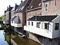 Hanging kitchens of Appingedam
 -
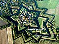 Star fort of Bourtange
 -
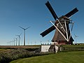 Windmill Goliath in Eemshaven
 -
 Strawboard factory in Scheemda


Sports[edit]

FC Groningen from the city of Groningen is the only football club from the province in the Eredivisie.[47] Their home stadium Euroborg has a capacity of 22,550 seats.[48] In the 2012–2013 competition, FC Groningen became 7th of the 18 teams.[49] SC Veendam played in the Eerste Divisie, but filed for bankruptcy in 2013.[50]
The city of Groningen is also the base of basketball club GasTerra Flames, volleyball club Lycurgus, and korfball club Nic.[51]
The ice rink at the multi-sport center Kardinge in the city of Groningen is used for national speed skating championships, most recently the 2013 KNSB Dutch Sprint Championships.[52]
Politics[edit]
This section needs to be updated. (June 2015) |

A provincial government in the Netherlands consists of a Provincial Council, the directly elected legislative branch, and a Provincial Executive, the executive branch. The King's Commissioner, who is appointed by the national government, is chairman of both branches.[53] The Provincial Council of Groningen consists of 43 members and the Provincial Executive consists of the King's Commissioner and six deputies.[54] The government has its seat in the city of Groningen, which is the provincial capital.
René Paas, member of the Christian Democratic Appeal (CDA), has been the King's Commissioner since 18 April 2016.[55] He succeeded Max van den Berg who was the King's Commissioner in Groningen from 2007 to 2016.[53]
In the provincial elections of 2011, the Labour Party became the largest party with nearly 25% of the votes and 12 seats in the Provincial Council. The next three largest parties are the People's Party for Freedom and Democracy (VVD) and the Socialist Party (SP) with 6 seats each, and the Christian Democratic Appeal (CDA) with 5 seats.[56] In 2011, two months after the elections, the member of the Party for the North (PvhN) continued as an independent under the name Free Mandate.[57][58] The next provincial elections are planned for 18 March 2015.[59]
Following the 2011 elections, the Provincial Executive was formed by a coalition of the Labour Party, the People's Party for Freedom and Democracy, Democrats 66 (D66), and GreenLeft (GL).[60] In 2013, GreenLeft left the coalition and was replaced by the ChristianUnion (CU).[61] The Labour Party has three deputies, the other coalition parties have one deputy each.[62]
| Party | Votes | % | Seats | |||
|---|---|---|---|---|---|---|
| Socialist Party | 39,093 | 16.19 | 8 | |||
| Labour Party | 29,711 | 12.30 | 6 | |||
| Christian Democratic Appeal | 27,160 | 11.25 | 5 | |||
| Democrats 66 | 23,422 | 9.70 | 4 | |||
| People's Party for Freedom and Democracy | 22,089 | 9.15 | 4 | |||
| Christian Union | 21,124 | 8.75 | 4 | |||
| Party for Freedom | 19,340 | 8.01 | 3 | |||
| Groninger Belang | 15,869 | 6.57 | 3 | |||
| GroenLinks | 15,701 | 6.50 | 3 | |||
| Party for the Animals | 9,078 | 3.76 | 2 | |||
| Party for the North | 5,173 | 2.14 | 1 | |||
| Other parties | 13,719 | 5.68 | 0 | |||
| Total | 241,479 | 100 | 43 | |||
Transportation[edit]
Roads[edit]

In the province of Groningen, there are three national roads (Dutch: rijkswegen), which are maintained by Rijkswaterstaat.[64][65] The motorway A7 (E22) connects the city of Groningen with the provinces of Friesland and North Holland in the west and with Winschoten and Germany in the east. The motorway is interrupted for the ring road of the city of Groningen, where it is the expressway N7.[66] The motorway A28 (E232) starts at the city of Groningen and runs south connecting it with the provinces of Drenthe, Overijssel, Gelderland, and Utrecht.[67] The expressway N33 runs south from Eemshaven, via Appingedam and Veendam, to Drenthe.[68] Other roads are overseen by the province (N roads), municipalities, or water boards.[64]
Public transport[edit]


Public transport falls under the rules for government procurement in the European Union. Tenders for regional bus and railway services are selected by the province of Groningen. Qbuzz is contracted for bus services in the period 2009–2015 and Arriva for railway services in the period 2005–2020.[69] Nederlandse Spoorwegen operates the railway services from Groningen railway station southward to Drenthe and beyond.
The railway network in the Netherlands is maintained by ProRail.[70] There are six railways located partially or entirely in the province of Groningen. The railway station Groningen connects several of these railways.[71]
| Trajectory | Railway stations in Groningen[71] |
|---|---|
| Groningen–Delfzijl | Groningen – Groningen Noord – Sauwerd – Bedum – Stedum – Loppersum – Appingedam – Delfzijl West – Delfzijl |
| Harlingen–Nieuweschans | Friesland – Grijpskerk – Zuidhorn – Groningen – Groningen Europapark – Kropswolde – Martenshoek – Hoogezand-Sappemeer – Sappemeer Oost – Zuidbroek – Scheemda – Winschoten – Bad Nieuweschans |
| Ihrhove–Nieuweschans | Germany – Bad Nieuweschans |
| Meppel–Groningen | Drenthe – Haren – Groningen Europapark – Groningen |
| Sauwerd–Roodeschool | Sauwerd – Winsum – Baflo – Warffum – Usquert – Uithuizen – Uithuizermeeden – Roodeschool |
| Stadskanaal–Zuidbroek | Veendam – Zuidbroek |
Airports[edit]

The international airport that serves Groningen is Groningen Airport Eelde, which is located in Eelde in the province of Drenthe. The airport is co-owned by the provinces of Groningen and Drenthe and the municipalities of Groningen, Assen, and Tynaarlo.[72] Its summer destinations are Antalya, Faro, Girona, Gran Canaria, Heraklion, Kos, Palma de Mallorca, and Tenerife. Its winter destinations are Innsbruck and Salzburg.[73] Starting on 5 June 2014, there will also be flights to London.[74] For other international destinations, Amsterdam Airport Schiphol is the nearest airport. The general aviation airports in the province are Oostwold Airport in Oostwold[75] and Stadskanaal Airfield in Stadskanaal.[76]
Science and education[edit]

The University of Groningen in the city of Groningen was founded in 1614[77] and is the only research university (universiteit) in the province. On 1 September 2013, it had 29,407 students and 5,238 full-time equivalent of staff members.[78] The university has ten faculties: Arts, Behavioural and Social Sciences, Economics and Business, Law, Mathematics and Natural Sciences, Medical Sciences, Philosophy, Spatial Sciences, Theology and Religious Studies, and University College Groningen.[79]
The Hanze University of Applied Sciences, the NHL University of Applied Sciences, and the Stenden University of Applied Sciences in the city of Groningen are the province's publicly funded universities of applied sciences (hogescholen).
Media[edit]
The Dagblad van het Noorden is a regional daily newspaper based in the city of Groningen and is owned by NDC Mediagroep. It was founded in 2002 by merging the Nieuwsblad van het Noorden, the Groninger Dagblad, and the Drentse Courant.[80] In 2015, the newspaper had a circulation of 96,515.[81]
RTV Noord is a regional public broadcaster of radio and television based in the city of Groningen, with Radio Noord and TV Noord.[82] Their radio station has 121,000 daily listeners and a market share of 28% (2012) and their TV station has 171,000 daily viewers and a market share of 26.7% (2012).[83][84]
Notable residents[edit]
People from the province of Groningen:
|
|
See also[edit]
References[edit]
- ^ "CBS Statline". opendata.cbs.nl.
- ^ Statistieken provincie Groningen - Gegevens over meer dan 100 onderwerpen!, AlleCijfers.nl
- ^ "EU regions by GDP, Eurostat". Retrieved 18 September 2023.
- ^ "Sub-national HDI - Area Database - Global Data Lab". hdi.globaldatalab.org. Retrieved 13 September 2018.
- ^ "CBS StatLine". opendata.cbs.nl.
- ^ "CBS Statline". opendata.cbs.nl.
- ^ a b Hanseatic city, Toerisms Groningen. Retrieved on 27 January 2014.
- ^ Groningen, Canadiansoldiers.com. Retrieved on 8 April 2014.
- ^ (in Dutch) "Hanneke Jagersma burgemeeste Beerta", Nieuwsblad van het Noorden, 1982. Retrieved on 8 April 2014.
- ^ a b (in Dutch) Uitersten, Oude stafkaarten verzamelen. Retrieved on 2 June 2014.
- ^ a b (in Dutch) Bodemgebruik; uitgebreide gebruiksvorm, per gemeente, Statistics Netherlands, 2013. Retrieved on 14 April 2014.
- ^ Groningen province, University of Groningen, 2012. Retrieved on 14 April 2014.
- ^ (in Dutch) Hasseberg (Gemeente Vlagtwedde) Archived 15 April 2014 at the Wayback Machine, RTV Noord, 2011. Retrieved on 14 April 2014.
- ^ Rafael Sandrea, Global Natural Gas Reserves – A Heuristic Viewpoint Archived 4 March 2016 at the Wayback Machine, IPC Petroleum Consultants, 2005. Retrieved on 14 April 2014.
- ^ a b (in Dutch) Aardbevingen door gaswinning in Noord-Nederland, Royal Netherlands Meteorological Institute, 2013. Retrieved on 27 January 2014.
- ^ The Wadden Sea, UNESCO World Heritage Centre. Retrieved on 14 April 2014.
- ^ Bernardus Mourik, Staatkundige historie van Holland (in Dutch), 1768, vol. 25, pp. 7–9. Retrieved 2 June 2014.
- ^ Indeling van Nederland in 40 COROP-gebieden Archived 5 January 2018 at the Wayback Machine (in Dutch), Statistics Netherlands. Retrieved 25 March 2014.
- ^ a b c "Bevolkingsontwikkeling; regio per maand" [Population growth; regions per month]. CBS Statline (in Dutch). CBS. 1 January 2021. Retrieved 2 January 2022.
- ^ a b c d "Kerncijfers wijken en buurten 2020" [Key figures for neighbourhoods 2020]. StatLine (in Dutch). CBS. 24 July 2020. Retrieved 19 September 2020.
- ^ (in Dutch) Nieuw Beerta, langjarige gemiddelden, tijdvak 1981-2010, Royal Netherlands Meteorological Institute. Retrieved on 25 March 2014.
- ^ (in Dutch) Volkstelling 1899; algemene uitkomsten per gemeente, Statistics Netherlands, 1999. Retrieved on 25 March 2014.
- ^ (in Dutch) Volkstelling 1930; bewoners naar geslacht en geboorteplaats, Statistics Netherlands, 2006. Retrieved on 25 March 2014.
- ^ (in Dutch) Bevolkingsontwikkeling; levendgeborenen, overledenen en migratie per regio, Statistics Netherlands, 2013. Retrieved on 12 March 2014.
- ^ "Population dynamics; birth, death and migration per region". Retrieved 8 September 2022.
- ^ (in Dutch) Bevolkingsontwikkeling; regio per maand, Statistics Netherlands, 2014. Retrieved on 12 March 2014.
- ^ (in Dutch) Bevolking op 1 januari; leeftijd, geboorteland en regio, Statistics Netherlands, 2013. Retrieved on 25 March 2014.
- ^ Helft Nederlanders is kerkelijk of religieus, CBS, 22 december 2016
- ^ a b c (in Dutch) Algemeen Archived 1 April 2019 at the Wayback Machine, Economie.groningen.nl. Retrieved on 8 April 2014.
- ^ Facts and figures Archived 6 February 2017 at the Wayback Machine, University Medical Center Groningen, 2015. Retrieved 28 January 2017.
- ^ Key figures, University of Groningen, 2016. Retrieved 28 January 2017.
- ^ Concern en burgercontacten (in Dutch), Municipality of Groningen. Retrieved 28 January 2017.
- ^ "Slechts 10 deelenemers aan cursus hoogtevrees DUO Archived 8 April 2014 at the Wayback Machine" (in Dutch), RTV Noord, 2011. Retrieved on 8 April 2014.
- ^ About us[permanent dead link], Gasunie. Retrieved 28 January 2017.
- ^ The ports, Groningen Seaports. Retrieved on 27 January 2014.
- ^ Facts & Figures 2015, Groningen Seaports. Retrieved 28 January 2017.
- ^ (in Dutch) Over Chemie Park, Chemie Park Delfzijl. Retrieved on 8 April 2014.
- ^ (in Dutch) Eemscentrale, GDF Suez. Retrieved on 8 April 2014.
- ^ Vattenfall Archived 27 May 2020 at the Wayback Machine, Vattenfall. Retrieved on 25 May 2020.
- ^ (in Dutch) Eemshavencentrale, Essent. Retrieved on 16 April 2014.
- ^ "Regional GDP per capita ranged from 30% to 263% of the EU average in 2018". Eurostat.
- ^ Jane Whaley, "The Groningen Gas Field Archived 19 October 2013 at the Wayback Machine", GEO ExPro Magazine, 2009. Retrieved on 27 January 2014.
- ^ (in Dutch) Beroepsbevolking; kerncijfers provincie, Statistics Netherlands, 2014. Retrieved on 26 March 2014.
- ^ (in Dutch) Over ons Archived 11 January 2014 at the Wayback Machine, Museumhuis Groningen. Retrieved on 18 March 2014.
- ^ (in Dutch) Aangesloten organisaties Museumhuis Groningen februari 2014 Archived 18 March 2014 at the Wayback Machine, Museumhuis Groningen, 2014. Retrieved on 18 March 2014.
- ^ (in Dutch) Bezoekcijfers erfgoedinstellingen Groningen Archived 21 August 2016 at the Wayback Machine, Stichting Erfgoedpartners, 2016. Retrieved 14 May 2016.
- ^ (in Dutch) "Stand Eredivisie 2013/2014 Archived 13 April 2014 at the Wayback Machine", Voetbal International, 2014. Retrieved on 13 April 2014.
- ^ (in Dutch) Stadion Euroborg Archived 14 April 2014 at the Wayback Machine, FC Groningen. Retrieved on 13 April 2014.
- ^ (in Dutch) "Stand Eredivisie 2012/2013 Archived 15 April 2014 at the Wayback Machine", Voetbal International, 2013. Retrieved on 13 April 2014.
- ^ (in Dutch) "Reddingsactie niet gelukt; SC Veendam definitief failliet", Algemeen Dagblad, 2013. Retrieved on 13 April 2014.
- ^ (in Dutch) Home Archived 14 April 2014 at the Wayback Machine, Energy Valley Topclub. Retrieved on 13 April 2014.
- ^ (in Dutch) "Dit weekend NK Sprint Kardinge", OOG Radio en TV, 2013. Retrieved on 13 April 2014.
- ^ a b Provincial Council and Provincial Executive Archived 4 January 2014 at the Wayback Machine, Province of Groningen. Retrieved on 28 January 2014.
- ^ (in Dutch) Over Gedeputeerde Staten, Province of Groningen. Retrieved on 28 January 2014.
- ^ Mr.Drs. F.J. (René) Paas (in Dutch), Parlement & Politiek, 2016. Retrieved 11 June 2016.
- ^ (in Dutch) Verkiezingsuitslagen Provinciale Staten 1918 - heden Archived 25 December 2013 at the Wayback Machine, Electoral Council. Retrieved on 27 January 2014.
- ^ (in Dutch) "Lijsttrekker breekt met Partij voor het Noorden", Dagblad van het Noorden, 2011. Retrieved on 16 June 2014.
- ^ (in Dutch) Fracties, Province of Groningen. Retrieved on 16 June 2014.
- ^ (in Dutch) Provinciale staten, Kiesraad. Retrieved on 3 June 2014.
- ^ (in Dutch) Collegeprogramma 2011-2015, Province of Groningen. Retrieved on 28 January 2014.
- ^ (in Dutch) Henk Staghouwer nieuwe gedeputeerde in Groningen: ChristenUnie vervangt GroenLinks, Groninger Internet Courant, 2013. Retrieved on 27 January 2014.
- ^ (in Dutch) Leden Gedeputeerde Staten, Province of Groningen. Retrieved on 16 June 2014.
- ^ (in Dutch) Verkiezingsuitslagen Provinciale Staten 1918 - heden Archived 25 December 2013 at the Wayback Machine, Electoral Council. Retrieved 19 June 2016.
- ^ a b (in Dutch) Wat voor wegen zijn er in Nederland en wie is de wegbeheerder? Archived 15 March 2014 at the Wayback Machine, Rijksoverheid. Retrieved on 15 March 2014.
- ^ (in Dutch) Wegenoverzicht Archived 15 March 2014 at the Wayback Machine, Rijkswaterstaat. Retrieved on 15 March 2014.
- ^ (in Dutch) A7 Archived 15 March 2014 at the Wayback Machine, Rijkswaterstaat. Retrieved on 15 March 2014.
- ^ (in Dutch) A28 Archived 15 March 2014 at the Wayback Machine, Rijkswaterstaat. Retrieved on 15 March 2014.
- ^ (in Dutch) N33 Archived 15 March 2014 at the Wayback Machine, Rijkswaterstaat. Retrieved on 15 March 2014.
- ^ (in Dutch), Openbaar vervoer, Province of Groningen. Retrieved on 17 March 2014.
- ^ (in Dutch) Wat doet ProRail, ProRail. Retrieved on 17 March 2014.
- ^ a b (in Dutch) Leeuwarden - Groningen, Sporenplan. Retrieved on 8 March 2014.
- ^ (in Dutch) Bestuur & Management Team, Groningen Airport Eelde. Retrieved on 17 March 2014.
- ^ Destinations Archived 8 March 2014 at the Wayback Machine, Groningen Airport Eelde. Retrieved on 8 March 2014.
- ^ (in Dutch) "Airport Eelde krijgt vlucht naar Londen Archived 7 April 2014 at the Wayback Machine", Dagblad van het Noorden, 2014. Retrieved on 3 April 2014.
- ^ Home Archived 14 July 2012 at the Wayback Machine, Oostwold Airport. Retrieved on 8 March 2014.
- ^ (in Dutch) Vliegveld Stadskanaal, Stadskanaal Airfield. Retrieved on 8 March 2014.
- ^ Who are we?, University of Groningen, 2013. Retrieved on 28 January 2014.
- ^ Key Figures, University of Groningen, 2014. Retrieved on 6 April 2014.
- ^ Faculties, University of Groningen. Retrieved on 6 April 2014.
- ^ "Dagblad van het Noorden" (in Dutch), Trouw, 2001. Retrieved on 14 April 2014.
- ^ Abonneeverlies Dagblad van het Noorden vlakt af (in Dutch), RTV Noord, 2016 Retrieved 3 June 2016.
- ^ Jaarverslag 2012 Archived 23 March 2014 at the Wayback Machine (in Dutch), RTV Noord, 2013. Retrieved on 13 April 2014.
- ^ RTV Noord (in Dutch), Omroep Reclame Nederland. Retrieved on 2 September 2014.
- ^ Bereik regionale omroepen blijft dalen (in Dutch), Nu.nl, 2013. Retrieved on 2 September 2014.
External links[edit]
- Province of Groningen
 , official government website
 - Nothing Tops Groningen, official tourism website
 Texts on Wikisource:
- Groningen in Holland and its People (1874)
- Groningen (province) in The New International Encyclopædia (1905)
Municipalities of Groningen | ||
|---|---|---|
 | ||
| ||
 | ||
|  | |||||
| County | ||||||
| Cities | ||||||
| Dependent territories | ||||||
1 until 1648; 2 until 1659; 3 until 1678.
Circles est. 1500: Bavarian, Swabian, Upper Rhenish, Lower Rhenish–Westphalian, Franconian, (Lower) Saxon Circles est. 1512: Austrian, Burgundian, Upper Saxon, Electoral Rhenish · Unencircled territories | ||||||
| International | |
|---|---|
| National | |
| Geographic | |