Khost Province
Khost
خوست | |
|---|---|
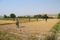
 U.S. soldiers in Khost province (June 2013) | |
 Map of Afghanistan with Khost highlighted | |
| Country | |
| Capital | Khost |
| Government | |
| • Governor | Abdul Jabbar Naeemi |
| Area | |
| • Total | 4,152 km2 (1,603 sq mi) |
| Population | |
| • Total | 546,800 |
| • Density | 130/km2 (340/sq mi) |
| Time zone | UTC+4:30 |
| Area code | AF-KHO |
| Main languages | Pashto and Persian |
Khost (Pashto: خوست, Persian: خوست) is one of the 34 provinces of Afghanistan, located in the eastern part of the country next to Pakistan's Federally Administered Tribal Areas (FATA). Khost province used to be part of Paktia province in the past. The city of Khost serves as the capital of Khost province. The population of the province is around 546,800,[1] which is mostly a tribal society. Khost Airport serves the province for domestic flights to Afghanistan's capital, Kabul.
Photos
 |
 |
 |
 |
History
| History of Afghanistan |
|---|
 |
| Timeline |
This section needs expansion. You can help by adding to it. (October 2014) |
Khost province under the Maurya Empire

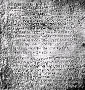
While the Diadochi were warring amongst themselves, the Mauryan Empire was developing in the northern part of the Indian subcontinent. The founder of the empire, Chandragupta Maurya, confronted a Macedonian invasion force led by Seleucus I in 305 BC and following a brief conflict, an agreement was reached as Seleucus ceded Gandhara and Arachosia (centered around ancient Kandahar) and areas south of Bagram (corresponding to the extreme south-east of modern Afghanistan) to the Mauryans. During the 120 years of the Mauryans in southern Afghanistan, Buddhism was introduced and eventually become a major religion alongside Zoroastrianism and local pagan beliefs. The ancient Grand Trunk Road was built linking what is now Kabul to various cities in the Punjab and the Gangetic Plain. Commerce, art, and architecture (seen especially in the construction of stupas) developed during this period. It reached its high point under Emperor Ashoka whose edicts, roads, and rest stops were found throughout the subcontinent. Although the vast majority of them throughout the subcontinent were written in Prakrit, Afghanistan is notable for the inclusion of 2 Greek and Aramaic ones alongside the court language of the Mauryans.
Inscriptions made by the Mauryan Emperor Ashoka, a fragment of Edict 13 in Greek, as well as a full Edict, written in both Greek and Aramaic has been discovered in Kandahar. It is said to be written in excellent Classical Greek, using sophisticated philosophical terms. In this Edict, Ashoka uses the word Eusebeia ("Piety") as the Greek translation for the ubiquitous "Dharma" of his other Edicts written in Prakrit:
- "Ten years (of reign) having been completed, King Piodasses (Ashoka) made known (the doctrine of) Piety (εὐσέβεια, Eusebeia) to men; and from this moment he has made men more pious, and everything thrives throughout the whole world. And the king abstains from (killing) living beings, and other men and those who (are) huntsmen and fishermen of the king have desisted from hunting. And if some (were) intemperate, they have ceased from their intemperance as was in their power; and obedient to their father and mother and to the elders, in opposition to the past also in the future, by so acting on every occasion, they will live better and more happily." (Trans. by G.P. Carratelli[2])
The last ruler in the region was probably Subhagasena (Sophagasenus of Polybius), who, in all probability, belonged to the Ashvaka (q.v.) background.
Recent history
In September 2011, work on the construction of Khost International Airport began. It is estimated the airport will cost $2.5 million. The funds for the project are being provided by the Afghan government. The airport will be located in a desert between Ismailkhel and Tani District.[3][4]
Politics and governance
The current governor of the Province is Abdul Jabbar Naeemi.[5] The city of Khost is the capital of Khost province. All law enforcement activities throughout the province are controlled by the Afghan National Police (ANP). The border of Afghanistan's Khost province with neighboring Pakistan's FATA is monitored and protected by the Afghan Border Police (ABP), which is part of the ANP. The border is called the Durand Line and is known to be one of the most dangerous in the world due to heavy militant activities and illegal smugglings. A provincial police chief is assigned to lead both the ANP and ABP. The police chief represents the Ministry of the Interior in Kabul. The ANP is backed by other Afghan National Security Forces (ANSF), including the NATO-led forces.
Healthcare
The percentage of households with clean drinking water increased from 34% in 2005 to 35% in 2011.[6] The percentage of births attended to by a skilled birth attendant increased from 18% in 2005 to 32% in 2011.[6]
Education
The overall literacy rate (6+ years of age) fell from 28% in 2005 to 15% in 2011.[6] The overall net enrolment rate (6–13 years of age) fell from 38% in 2005 to 37% in 2011.[6]
Demographics


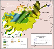
The population of Khost province is around 546,800.[1] The Pashtun people make up 99% of the population, with the remaining 1% being Tajiks and others.[5]
Districts
| District | Capital | Population | Area[7] | Notes |
|---|---|---|---|---|
| Bak | 27,675 | |||
| Gurbuz | 30,751 | |||
| Zazi Maidan | 23,197 | |||
| Khost Matun|Capital | 120,214 | |||
| Mandozayi | 41,682 | |||
| Musakhel | 31,998 | |||
| Nadir Shah Kot | 37,193 | |||
| Qalandar | 11,406 | |||
| Sabari | 49,779 | |||
| Shamal | 13,523 | Shifted from Paktia Province in 2005 | ||
| Spera | 26,685 | |||
| Tani | 42,096 | |||
| Tirazayi |
See also
References
- ^ a b c "Settled Population of Khost province by Civil Division, Urban, Rural and Sex-2012-13" (PDF). Islamic Republic of Afghanistan: Central Statistics Organization. Retrieved 2014-01-18.
- ^ History of Afghanistan
- ^ Muhammad Haroon, ed. (December 7, 2013). "Official wants Khost Airport contract reconsidered". Pajhwok Afghan News. Retrieved October 30, 2014.
- ^ Muhammad Haroon, ed. (September 10, 2014). "Delay in completion of airport deplored". [Pajhwok Afghan News. Retrieved October 30, 2014.
- ^ a b "Khost Province" (PDF). Program for Culture & Conflict Studies. Naval Postgraduate School. Retrieved 2014-01-18.
- ^ a b c d Archive, Civil Military Fusion Centre, https://www.cimicweb.org/AfghanistanProvincialMap/Pages/Khost.aspx
- ^ Afghanistan Geographic & Thematic Layers
- Blowback: The Costs and Consequences of American Empire, by Chalmers Johnson, ISBN 0-8050-6239-4
- "Ghost Wars"
