
Mahanad
Mahanad | |
|---|---|
Village | |
 Mahanad Chowrasta | |
 Mahanad Location in West Bengal, India  Mahanad Mahanad (India) | |
| Coordinates: 23°00′N 88°16′E / 23.00°N 88.26°E | |
| Country | |
| State | West Bengal |
| District | Hooghly |
| Government | |
| • Type | Panchayati raj (India) |
| • Body | Gram panchayat |
| Elevation | 15 m (49 ft) |
| Languages | |
| • Official | Bengali, English |
| Time zone | UTC+5:30 (IST) |
| PIN | 712149, 712148 |
| Telephone code | 03213 |
| ISO 3166 code | IN-WB |
| Vehicle registration | WB |
| Lok Sabha constituency | Hooghly |
| Vidhan Sabha constituency | Saptagram |
Mahanad is a gram panchayat, or village, in Polba-Dadpur CD block in Chinsurah subdivision of Hooghly district in the Indian state of West Bengal[1][2][3]
Geography[edit]

5miles
River
M: municipal corporation/ municipal city/ town, CT: census town, R: rural/ urban centre,
Owing to space constraints in the small map, the actual locations in a larger map may vary slightly
History[edit]
Archaeological Survey of India (ASI) has found many historic artifacts dating from the Gupta Era in Mahanad. An ancient lord Shiva temple in Mahanad is called Jateswer Shiv Temple. Mahand has been the yogpeeth (yoga retreat) of Nath Yogis, for thousands of years.[4][5]
Mahanad has an excavated site revealing a historic Kushan presence. The exploration conducted by ASI and Paresh Pal, a local antiquarian, have led to the discovery of coins of the Kushan and Gupta dynasties and terracotta, mostly of Gupta style.[6]
Location[edit]
Mahanad is located at 23°00′N 88°16′E / 23.00°N 88.26°E.[7] It has an average elevation of 15 metres above sea level. Mahanad is located around 19 kilometer away from its district headquarters, Hugli-Chuchura. The nearest railway station is Pandua in the Howrah-Bardhaman main line around 7 km away.[8]
Temple and attractions[edit]
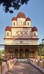
- Mahanad Kali Temple also Called Brahmamoyee Kali Mandir (Established in 1830).[9]
- Jateswer Shiva Mandir, 18th century temple of Nath sect in Hooghly district[10][11]
- Lal Jew Temple
- Jora Shiva Temple
Education[edit]
Primary and secondary education[edit]
- Spark School, (established in 2012) CBSE[12]
- Mahanad High School, (Established in 1963)[13]
- Ramkrishna High School, (Established in 1984)
- Institute of Little Star
- Shitala Prathamik Vidyalaya
- Sima Prathamik Vidyalaya
- Harmala Primary School
- Ramakrishna Vidyapith
Festivals[edit]
Kali Puja and Maha Shivaratri[14] are festivals celebrated in Mahanad. Lakshmi Puja and Saraswati Puja are widely celebrated at Mahanad as well. Shivratri Mela (fair) is the biggest fair observed at Mahanad each year, during the Maha Shivaratri festival.
Economy[edit]
Banks: At Mahanad, there are branches of banks such as Central Bank Of India,[18]Central Bank Of India, Bandhan Bank, Ujjivan Small Finance Bank .[19]
Mahanad picture gallery[edit]
-
 Brohmomoyee kali maa
 -
 Mahanad Jora Shiva Temple
 -
 Mahanad Jateswar Shiv temple complex
 -
 Ruins of Mahanad Rajbari at Mahanad
 -
 Brohmomoyee Kali Temple front view
 -
 Brohmomoyee Kali mandir, backside view


References[edit]
- ^ "National Panchayat Portal".
- ^ (09_Chapter III), Study of Kushan Materials (2013). "New Look On The Kushan Bengal : A Study On Archaeological / Historical Materials". Shodhganga : a reservoir of Indian theses @ INFLIBNET. University of Calcutta. pp. 110–112. hdl:10603/164964?mode=full.
{{cite web}}: CS1 maint: numeric names: authors list (link) - ^ District-wise list of statutory towns Archived 2011-07-21 at the Wayback Machine
- ^ Bandyopadhyay, P. K. (1992). Natha Cult and Mahanad. page 80-90, Delhi, India: B.R. Publishing Corporation.
- ^ "Census of India 2011, West Bengal: District Census Handbook, Hooghly" (PDF). Census of India 2011 WEST BENGAL. pp. 120–122.
- ^ Chapter IV, Study of Kushan Materials. "New look on the kushan bengali A study on archaeological historical materials". University of Calcutta. pp. 155–156. hdl:10603/164964?mode=full.
- ^ "Find Latitude and Longitude". Find Latitude and Longitude. Retrieved 12 June 2021.
- ^ "District Statistical Handbook". Retrieved 5 June 2021.
- ^ "মহানাদ কালী বাড়ির পুজো". EiSamay potrika.
- ^ "Census of India 2011, West Bengal: District Census Handbook, Hooghly" (PDF). Census of India 2011 WEST BENGAL. Directorate of Census Operations, West Bengal. 2011. pp. 120–122.
- ^ Dāsa, Bhūpatirañjana (1978). Paścimabaṅga bhramaṇa o darśana (in Bengali). Śarat̲ Pābalisiṃ Hāusa.
- ^ "The Spark School". www.sparkgroup.in. Retrieved 5 June 2021.
- ^ "WBBSE :: Affiliated Schools Malda". wbbse.org. Retrieved 10 June 2021.
- ^ "Census of India 2011, West Bengal: District Census Handbook, Hooghly" (PDF). Census of India 2011 WEST BENGAL. Directorate of Census Operations, West Bengal. pp. 121–112.
- ^ "Labour Department of West Bengal".
- ^ "Establishment Information | Government Of West Bengal". wblc.gov.in. Retrieved 10 June 2021.
- ^ "List of functioning Cold Storage of West Bengal District wise as on 18.01.07". West Bengal State Marketing Board. Archived from the original on 22 January 2009. Retrieved 2 June 2021.
- ^ "CENTRAL BANK OF INDIA MAHANAND NAGAR PARA, WEST BENGAL IFSC Code: Find CENTRAL BANK OF INDIA MAHANAND NAGAR PARA MICR Code, IFSC Code on The Economic Times". The Economic Times. Retrieved 5 June 2021.
- ^ "MOF Result". dbie.rbi.org.in. Retrieved 5 June 2021.