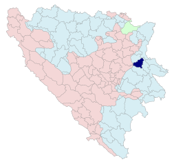
Vlasenica
Vlasenica
Власеница | |
|---|---|
 Location of Vlasenica within Bosnia and Herzegovina | |
| Country | |
| Entity | |
| Government | |
| • Mayor | Željko Popović[1] (SNSD) |
| Area | |
| • Total | 44,814 km2 (17,303 sq mi) |
| Population (2013 census) | |
| • Total | 12,349 |
| • Density | 548/km2 (1,420/sq mi) |
| Time zone | UTC+1 (CET) |
| • Summer (DST) | UTC+2 (CEST) |
| Area code | 56 |

Vlasenica (Cyrillic: Власеница) is a municipality and town in Bosnia and Herzegovina. Administratively it is part of Vlasenica Region.
Population
1912
According to the book notes out of "Bosnischer Bote" ("Bosanski Glasnik", translated by Fikret Bahtijarević, s.r.) in 1912 Vlasenica had 1,917 citizens, out of which 1,480 were Bosniaks, 398 Serbs, 72 Croats and 12 Evangelicals.
1971
26,623 total
- Serbs - 13,431 (50.44%)
- Bosniaks - 12,881 (48.38%)
- Croats - 42 (0.15%)
- Yugoslavs - 17 (0.06%)
- Others - 252 (0.97%)
1981
30,498 total
- Bosniaks - 15,337 (50.28)
- Serbs - 13,531 (44.36)
- Croats - 44 (0.14)
- Yugoslavs - 889 (2.91)
- Others - 697 (2.31)
1991
In the 1991 census the municipality had a population 33,817. The distribution was: [2]
- Bosniaks - 18,699 (55.29%)
- Serbs - 14,356 (42.25%)
- Yugoslavs - 336 (0.99%)
- Croats - 40 (0.12%)
- Others 386 (1.14%)
The town itself had a population of 7,916. The distribution was:
- Bosniaks - 4,794 (61%)
- Serbs - 2,777 (35%)
- Yugoslavs - 243 (0.03%)
- Croats - 28 (0.003%)
- others 74 (0.093%)
Notable people
See also
External links
Wikimedia Commons has media related to Vlasenica.
- http://www.vlasenica-turizam.org
- http://www.vlasenica.rs
- http://www.vlasenica.info
- http://www.vlasenica.eu
- Hotel "М" Vlasenica

