Beaver County, Pennsylvania: Difference between revisions
No edit summary |
|||
| Line 156: | Line 156: | ||
====High schools==== |
====High schools==== |
||
*[[Aliquippa High School]] |
*[[Aliquippa High School]] |
||
*[[Beaver Area High School]] |
|||
*[[Beaver Falls High School]] |
*[[Beaver Falls High School]] |
||
*[[Blackhawk High School]] |
*[[Blackhawk High School]] |
||
Revision as of 00:42, 1 September 2008
This article includes a list of references, related reading, or external links, but its sources remain unclear because it lacks inline citations. (April 2008) |
Beaver County | |
|---|---|
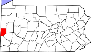
 Location within the U.S. state of Pennsylvania | |
 Pennsylvania's location within the U.S. | |
| Coordinates: 40°41′N 80°21′W / 40.69°N 80.35°W | |
| Country | |
| State | |
| Founded | March 12, 1800 |
| Seat | Beaver |
| Largest city | Aliquippa |
| Area | |
| • Total | 444 sq mi (1,150 km2) |
| • Land | 434 sq mi (1,120 km2) |
| • Water | 10 sq mi (30 km2) 2.18% |
| Population (2000) | |
| • Total | 181,412 |
| • Density | 420/sq mi (161/km2) |
| Website | www |
Beaver County is a county located in the U.S. state of Pennsylvania. As of the 2000 census, the population was 181,412.
Beaver County was created on March 12, 1800, from parts of Allegheny and Washington Counties. On May 31 1985, an F3 tornado hit northern portions of the county, as part of the eastern Ohio and western Pennsylvania tornado outbreak. Its county seat is BeaverTemplate:GR.
Beaver County is part of the Pittsburgh Metropolitan Statistical Area.
Geography
According to the U.S. Census Bureau, the county has a total area of 444 square miles (1,150 km²), of which, 434 square miles (1,125 km²) of it is land and 10 square miles (25 km²) of it (2.18%) is water.
Adjacent counties
- Lawrence County (north)
- Butler County (east)
- Allegheny County (southeast)
- Washington County (southeast)
- Hancock County, West Virginia (west)
- Columbiana County, Ohio (west)
Demographics
As of the censusTemplate:GR of 2000, there were 181,412 people, 72,576 households, and 50,512 families residing in the county. The population density was 418 people per square mile (161/km²). There were 77,765 housing units at an average density of 179 per square mile (69/km²). The racial makeup of the county was 92.55% White, 5.96% Black or African American, 0.10% Native American, 0.25% Asian, 0.01% Pacific Islander, 0.20% from other races, and 0.92% from two or more races. 0.72% of the population were Hispanic or Latino of any race. 23.0% were of German, 17.4% Italian, 9.9% Irish, 6.5% English, 6.4% Polish and 5.8% American ancestry according to Census 2000.
There were 72,576 households out of which 28.60% had children under the age of 18 living with them, 54.50% were married couples living together, 11.40% had a female householder with no husband present, and 30.40% were non-families. 26.90% of all households were made up of individuals and 13.10% had someone living alone who was 65 years of age or older. The average household size was 2.44 and the average family size was 2.96.
In the county, the population was spread out with 22.60% under the age of 18, 7.40% from 18 to 24, 27.30% from 25 to 44, 24.20% from 45 to 64, and 18.40% who were 65 years of age or older. The median age was 41 years. For every 100 females there were 91.90 males. For every 100 females age 18 and over, there were 88.20 males.
Municipalities

Under Pennsylvania law, there are four types of incorporated municipalities: cities, boroughs, townships, and, in at most two cases, towns. The following cities, boroughs and townships are located in Beaver County:
Cities
Boroughs
Townships
Transportation
Airports
Education
Colleges and universities
- Geneva College
- Mountain State University (Center Township Branch)
- Penn State Beaver Campus
- Trinity Episcopal School for Ministry
Community, junior, and technical colleges

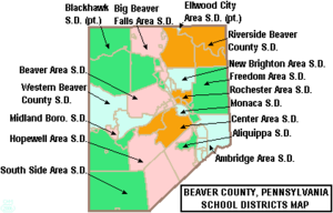
Public school districts
- Aliquippa School District
- Ambridge Area School District
- Beaver Area School District
- Big Beaver Falls Area School District
- Blackhawk School District
- Center Area School District
- Ellwood City Area School District
- Freedom Area School District
- Hopewell Area School District
- Midland Borough School District
- Monaca School District
- New Brighton Area School District
- Riverside Beaver County School District
- Rochester Area School District
- South Side Area School District
- Western Beaver County School District
High schools
- Aliquippa High School
- Beaver Area High School
- Beaver Falls High School
- Blackhawk High School
- Hopewell High School
- New Brighton High School
- Riverside High School
- Quigley Catholic High School
Law and government
Pennsylvania State Senate
- J.Barry Stout, Democrat, Pennsylvania's 38th Senatorial District
- Gerald J. LaValle, Democrat, Pennsylvania's 47th Senatorial District
Pennsylvania House of Representatives
- Christopher Sainato Democrat, Pennsylvania's 9th Representative District
- Jaret Gibbons Democrat, Pennsylvania's 10th Representative District
- Jim Marshall Republican, Pennsylvania's 14th Representative District
- Vincent A. Biancucci, Democrat, Pennsylvania's 15th Representative District
- Sean M. Ramaley Democrat, Pennsylvania's 16th Representative District
- Victor John Lescovitz Democrat, Pennsylvania's 46th Representative District
United States House of Representatives
Parks
- Raccoon Creek State Park a Pennsylvania state park
- Brady's Run Park
- Brush Creek Park
- Old Economy Park


