Greater Skopje: Difference between revisions
m robot Adding: nl:Groot Skopje |
No edit summary |
||
| Line 65: | Line 65: | ||
Skopje is located in the northern part of the [[Republic of Macedonia]], in the [[Skopje statistical region]]. The [[Vardar River]] flows through the city towards into the [[Aegean Sea]]. Skopje is located at an elevation of 255 meters above sea level. The city's land area is 1,854 [[km²]] (715.8 [[sq mi]]). |
Skopje is located in the northern part of the [[Republic of Macedonia]], in the [[Skopje statistical region]]. The [[Vardar River]] flows through the city towards into the [[Aegean Sea]]. Skopje is located at an elevation of 255 meters above sea level. The city's land area is 1,854 [[km²]] (715.8 [[sq mi]]). |
||
===Surrounding municipalities=== |
===Surrounding municipalities=== |
||
{| border=0 align=right cellpadding=0 cellspacing=0 style="margin: 0 0 1em 1em; background: #f9f9f9; border: 0px #aaaaaa solid; border-collapse: collapse; font-size: 95%;" |
|||
|<div style="position: relative">[[Image:Skopje MUNI.png |600px|left|thumb]] |
|||
<div style="position: absolute;font-size:80%;left:210px;top:115px">[[Image:MMCA(Gjorche_Petrov).png|20px]]</div><br> |
|||
<div style="position: absolute;font-size:80%;left:187px;top:135px">'''[[Gorče Petrov municipality|Gjorče Petrov <br>(''Ѓорче Петров'')]]'''</div> |
|||
<div style="position: absolute;font-size:80%;left:260px;top:85px">'''[[Suto Orizari municipality|Suto Orizari <br>(Шуто Оризари)]]'''</div> |
|||
<div style="position: absolute;font-size:80%;left:284px;top:65px">'''[[Image:MMCA(Shuto_Orizari).png|20px]]'''</div> |
|||
<div style="position: absolute;font-size:80%;left:88px;top:199px">[[Image:Sarajski grb.png|50px]]</div> |
|||
<div style="position: absolute;font-size:100%;left:98px;top:239px">[[Saraj municipality|Saraj <br/> ''(Сарај)'']]</div> |
|||
<div style="position: absolute;font-size:80%;left:398px;top:84px">[[Image:Butelski_grb.png|30px]]</div> |
|||
<div style="position: absolute;font-size:80%;left:353px;top:74px">'''[[Butel municipality|Butel <br> ''(Бутел)'']]'''</div> |
|||
<div style="position: absolute;font-size:80%;left:356px;top:259px">[[Image:MMCA(Centar).png|20px]]</div> |
|||
<div style="position: absolute;font-size:80%;left:358px;top:284px">'''[[Centar municipality|Centar <br> ''(Центар)'']]'''</div> |
|||
<div style="position: absolute;font-size:80%;left:361px;top:184px">'''[[Čair municipality|Čair <br> ''(Чаир)'']]'''</div> |
|||
<div style="position: absolute;font-size:80%;left:405px;top:359px">[[Image:MMCA(Kisela_Voda).png|25px]]</div> |
|||
<div style="position: absolute;font-size:80%;left:388px;top:384px">'''[[Kisela Voda municipality|Kisela Voda <br> ''(Кисела Вода)'']]'''</div> |
|||
<div style="position: absolute;font-size:80%;left:475px;top:279px">[[Image:Grb aerodrom.png|30px]]</div> |
|||
<div style="position: absolute;font-size:80%;left:515px;top:314px">'''[[Aerodrom municipality|Aerodrom <br> ''(Аеродром)'']]'''</div> |
|||
<div style="position: absolute;font-size:80%;left:475px;top:149px">[[Image:MMCA(Gazi Baba).png|30px]]</div> |
|||
<div style="position: absolute;font-size:80%;left:465px;top:189px">'''[[Gazi Baba municipality|Gazi Baba <br> ''(Гази Баба)'']]'''</div> |
|||
<div style="position: absolute;font-size:80%;left:335px;top:359px">[[Image:MMCA(Karposh).png|25px]]</div> |
|||
<div style="position: absolute;font-size:80%;left:280px;top:354px">'''[[Karpoš municipality|Karpoš <br> ''(Карпош)'']]'''</div> |
|||
|- |
|||
</div> |
|||
</div> |
|||
|} |
|||
{{Geographic Location (8-way) |
{{Geographic Location (8-way) |
||
|North= [[Čučer-Sandevo municipality|Čučer-Sandevo]], |
|North= [[Čučer-Sandevo municipality|Čučer-Sandevo]], |
||
Revision as of 19:41, 12 November 2008
| Greater Skopje | |
| File:Flag of Skopje.png | |
| Location | |

| |
|---|---|
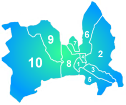
| Administrative division of Skopje | |

| |
| 1: Centar (Центар) |
6:Butel (Бутел) |
| 2:Gazi Baba (Гази Баба) |
7:Šuto Orizari (Шуто Оризари) |
| 3:Aerodrom (Аеродром) |
8:Karpoš (Карпош) |
| 4:Čair (Чаир) | 9:Gorche Petrov (Ѓорче Петров) |
| 5:Kisela Voda (Кисела Вода) |
10:Saraj (Сарај) |
| General information | |
| Area | 1818 km² |
| elevation | 240 |
| postal code | 1000 |
| area code | 02 |
| licence | SK |
| mayor | Trifun Kostovski |
| website | [1] |
| Population -density |
515,419 3603,94 people/km² |
Greater Skopje (Macedonian: Големо Скопје, Golemo Skopje, Albanian: Shkup, or Shkupi)[1]), is an administrative division within the Republic of Macedonia constituted of 10 municipalities. As a such administrative unit Skopje is the capital of the Republic of Macedonia. It is part of Skopje statistical region (Скопски регион).
The organisation of Greate Skopje, like a distinct unit of the local-selfgovernment is defined by the Law of Skopje.
Geography
Skopje is located in the northern part of the Republic of Macedonia, in the Skopje statistical region. The Vardar River flows through the city towards into the Aegean Sea. Skopje is located at an elevation of 255 meters above sea level. The city's land area is 1,854 km² (715.8 sq mi).
Surrounding municipalities
Municipalities
Skopje's 10 municipalities are:
| Municipality (Општина) |
HASC[2] | Municipality Center (Центар на Општината) |
Area (km²) |
Population (2002) |
|---|---|---|---|---|
| Aerodrom (Аеродром) | MK.AD | Aerodrom (Аеродром) | 21,85 | 72 009 |
| Butel (Бутел) | MK.BU | Butel (Бутел) | 54,79 | 36 154 |
| Čair (Чаир) | MK.CI | Čair (Чаир) | 3,52 | 64 773 |
| Centar (Центар) | MK.CE | Centar (Центар) | 7,52 | 45 412 |
| Gazi Baba (Гази Баба) | MK.GB | Gazi Baba (Гази Баба) | 110,86 | 72 617 |
| Gjorče Petrov (Ѓорче Петров) | MK.GP | Gjorče Petrov (Ѓорче Петров) | 66,93 | 41 634 |
| Karpoš (Карпош) | MK.KX | Karpoš (Карпош) | 35,21 | 59 666 |
| Kisela Voda (Кисела Вода) | MK.VD | Kisela Voda (Кисела Вода) | 34,24 | 57 236 |
| Saraj (Сарај) | MK.AJ | Saraj (Сарај) | 229,06 | 35 408 |
| Šuto Orizari (Шуто Оризари) | MK.SO | Šuto Orizari (Шуто Оризари) | 7,48 | 22 017 |
| Greater Skopje | Total | 1 818 | 515 419 | |
Demographics
According to the 2002 census, [3] the population of Skopje was 506,926 people. The main ethnic group are Macedonians, who make up 66.75% of the population, followed by Albanians (20.49%), Roma (4.63%), Serbs (2.82%), Turks (1.70%), Bosniaks (1.50%) and Aromanians (0.50%).
97.5% of the population over the age of 10 is literate.
History
- In 1945 by law, Macedonia territorially is organised in 4 areas, 32 subareas and 894 local peoples' councils.
- From 1949 to 1952 were brought six laws for territorial organisation.
- In 1952 the number of the municipalities has fallen from 223 to 86, and the subareas from 18 to 7.
- In 1957 there are 7 subareas and 73 municipalities in 1965.
- In 1965 with the law defining the areas of the municipalities in the Socialist Republic of Macedonia, the subareas were abolished and the number of the municipalities is 32.
- From 1976 until 1996 Macedonia Skopje is organised as a distinct social-political community comprising of 5 municipalities: Gazi Baba, Karpoš, Kisela Voda,Centar and Čair.
- From 1996 to 2004 Skopje is defined as a distinct unit of the local-selfgovernment and has 7 municipalities: Gazi Baba, Karpoš, Kisela Voda,Centar and Čair, Šuto Orizari and Gjorče Petrov.
Notes
- ^ Hierarchical Administrative Subdivision Codes (HASC): related to ISO subnational codes (yet undefined for Macedonian municipalities)
- ^ 2002 census results in English and Macedonian (PDF)
See also
External links
- ^ Qyteti i Shkupit (Albanian for City of Skopje) Official Website of the Municipality of Skopje, in Albanian Language


