
Thackley: Difference between revisions
m Cap |
Cyberbot II (talk | contribs) Rescuing 3 sources. #IABot |
||
| Line 92: | Line 92: | ||
Covering 42 hectares, Buck Wood is bordered by the curving route of the canal at its lower perimeter around 60 m above sea-level. |
Covering 42 hectares, Buck Wood is bordered by the curving route of the canal at its lower perimeter around 60 m above sea-level. |
||
Its highest boundary 135 m above sea level, is shaped by the tree-lined sweep of Ainsbury Avenue leading from Thackley through to Esholt.{{citation needed|date=September 2011}} |
Its highest boundary 135 m above sea level, is shaped by the tree-lined sweep of Ainsbury Avenue leading from Thackley through to Esholt.{{citation needed|date=September 2011}} |
||
Thackley itself forms the southern boundary of the Wood, and at the northern edge near Dawson Wood is where part of the land is taken up by [[Yorkshire Water]]'s waste water primary settling tanks.<ref name="MS:EWWTW">{{cite web |
Thackley itself forms the southern boundary of the Wood, and at the northern edge near Dawson Wood is where part of the land is taken up by [[Yorkshire Water]]'s waste water primary settling tanks.<ref name="MS:EWWTW">{{cite web|title=Esholt Waste Water Treatment Works |work=Morgan Sindall |format=PDF |accessdate=2 October 2011 |url=http://construction.morgansindall.com/what-we-do/water/water-profiles/esholt-waste-water-treatment-works |deadurl=yes |archiveurl=https://web.archive.org/20131024162803/http://construction.morgansindall.com/what-we-do/water/water-profiles/esholt-waste-water-treatment-works |archivedate=24 October 2013 }}</ref> |
||
Buck Wood lies above a layer of [[millstone grit]] rock with numerous rocky outcrops, especially on the steeper slopes, where quarrying has taken place.{{citation needed|date=September 2011}} |
Buck Wood lies above a layer of [[millstone grit]] rock with numerous rocky outcrops, especially on the steeper slopes, where quarrying has taken place.{{citation needed|date=September 2011}} |
||
| Line 115: | Line 115: | ||
[[File:Thackley Methodist Church - Thackley Road - geograph.org.uk - 612245.jpg|210px|thumb|right|Thackley Methodist Church (1889) on Thackley Road]] |
[[File:Thackley Methodist Church - Thackley Road - geograph.org.uk - 612245.jpg|210px|thumb|right|Thackley Methodist Church (1889) on Thackley Road]] |
||
Notable buildings include the large [[Methodist]] church on Thackley Road and the Methodist Community Hall that serves as a village hall for various groups and societies.<ref name="TMC">{{cite web |
Notable buildings include the large [[Methodist]] church on Thackley Road and the Methodist Community Hall that serves as a village hall for various groups and societies.<ref name="TMC">{{cite web|title=Thackley Methodist Church & Community Centre |accessdate=6 September 2011 |work=The Bradford North Circuit |url=http://www.bradfordnorth.org.uk/thackley.html |deadurl=yes |archiveurl=https://web.archive.org/20100909015212/http://www.bradfordnorth.org.uk:80/thackley.html |archivedate=9 September 2010 }}</ref> |
||
[[File:Thackley tunnel West portal - geograph.org.uk - 1439296.jpg|210px|thumb|left|Thackley Tunnel west portal]] |
[[File:Thackley tunnel West portal - geograph.org.uk - 1439296.jpg|210px|thumb|left|Thackley Tunnel west portal]] |
||
| Line 159: | Line 159: | ||
[[Image:Farm south of The Nosegay, Thackley - geograph.org.uk - 247671.jpg|210px|thumb|right|Low Ash Farm<sup>*</sup> in the north of Thackley village]] |
[[Image:Farm south of The Nosegay, Thackley - geograph.org.uk - 247671.jpg|210px|thumb|right|Low Ash Farm<sup>*</sup> in the north of Thackley village]] |
||
Thackley Corner and a section of Leeds Road to the west are home to most of the village's shops, pubs and eateries. Amenities include a dry cleaners,<ref name="TDC">{{cite web |
Thackley Corner and a section of Leeds Road to the west are home to most of the village's shops, pubs and eateries. Amenities include a dry cleaners,<ref name="TDC">{{cite web|title=Thackley Dry Cleaners |work=thackleydrycleaners.com |accessdate=1 May 2014 |url=http://www.thackleydrycleaners.com/ |deadurl=yes |archiveurl=https://web.archive.org/20140107210652/http://thackleydrycleaners.com/ |archivedate=7 January 2014 }}</ref> butcher, newsagent, salon and party shop.<ref name="Ideaz">{{cite web |title=Ideaz Party Shop |work=ideaz-uk.com |accessdate=1 May 2014 |url=http://www.ideaz-uk.com/}}</ref> |
||
There are three public houses in Thackley although currently only The Great Northern is open.<ref name="PG:T">{{cite web |title=Pubs in Thackley |work=Pubs Galore |accessdate=6 September 2011 |url=http://www.pubsgalore.co.uk/areas/thackley/west-yorkshire/}}</ref> |
There are three public houses in Thackley although currently only The Great Northern is open.<ref name="PG:T">{{cite web |title=Pubs in Thackley |work=Pubs Galore |accessdate=6 September 2011 |url=http://www.pubsgalore.co.uk/areas/thackley/west-yorkshire/}}</ref> |
||
Many of the properties in the north of the village are historic farm buildings and some have specialised in horseriding. |
Many of the properties in the north of the village are historic farm buildings and some have specialised in horseriding. |
||
Revision as of 20:54, 23 February 2016
| Thackley | |
|---|---|
 Thackley Corner, Thackley | |
| OS grid reference | SE17503870 |
| Metropolitan borough | |
| Metropolitan county | |
| Region | |
| Country | England |
| Sovereign state | United Kingdom |
| Post town | BRADFORD |
| Postcode district | BD10 |
| Dialling code | 01274 |
| Police | West Yorkshire |
| Fire | West Yorkshire |
| Ambulance | Yorkshire |
The village of Thackley is a small suburban area to the north of the city of Bradford, West Yorkshire in England. The village is loosely bordered by the village of Idle to the south, to the west by the West Royd area of Shipley and elsewhere by the Leeds and Liverpool Canal. Thackley is the northernmost part of Bradford south of the River Aire.
History
Prehistory
An archaeological project during 2009 funded by the Heritage Lottery Fund, revealed the site in Buck Wood of an enclosure that was in use as a settlement from Neolithic to post-Roman times.[1] The work, undertaken by The Friends of Buck Wood led by a professional archaeologist, showed that in the past a substantial boundary wall had been built of local unworked stone, enclosing a natural terrace of level ground now surrounded by woods.[1] This formed an oval enclosure, roughly 82 m by 78 m in size. The remains of a quern stone for grinding grain was found within this central area, as was a single cup marked carved rock. Leading away from the enclosure is an orthostat wall of large stones, part of a network of such walls in the wood.[1]
Industrial development

Historically the area formed part of the Lordship of Idle.[2] In the 17th century a tanning industry developed and in the 19th century sandstone was quarried, and mills were built for a local cotton industry.[3]
Brackendale Mill was a woollen mill established circa 1800 in the north of Thackley.[4] The mill was extended in 1829 with an engine house and water wheel[5] and in the 1870s a steam powered weaving shed was added to the site.[4][5] Today the mill building is living accommodation.
Recent dwelling development on Weavers Croft off Crag Hill Road occupies part of the site of the former Bowling Green Mills.[6]
Transport history

The Leeds and Liverpool Canal was built through the far north of Thackley in the 1770s.[7]
In 1845 railway construction began with the building of a two-track Thackley Railway Tunnel under Thackley Hill[6]—in use up until 1968. In 1900 a second adjacent and parallel tunnel was added on the northern side of the original to create a fast passenger line and a slow goods line on the Airedale Line.
In 1875 the Great Northern Railway opened its Shipley and Windhill Line, a 6.5 miles (10.5 km) double track branch line from Quarry Gap junction near Laisterdyke to Shipley and Windhill railway station, passing Eccleshill and Idle railway stations and Thackley railway station.[8] Thackley railway station, rebuilt in 1894, is in the middle of Thackley.[8] The line wasn't competitive and after 1931 it was made single line freight only, and progressively closed from 1966 to 1968.[8][9] The route through Thackley can be easily identified today—the rails have been removed and the route is overgrown by trees but the cuttings and original railway bridges in Thackley still remain.[6]
A trolleybus service ran from Shipley, West Yorkshire up to its terminus at Thackley Corner in the centre of Thackley.[citation needed]
The Open Air School
Between 1908 and 1939 sickly children from Bradford were bussed in to attend the Open Air School in Buck Wood.[10] Near the main entrance to Buck Wood on Ainsbury Avenue (private road) is a plateau originally formed from waste material created when the first railway tunnel was built under Buck Wood.[10] This flat raised area was used as a playground by children at the school and traces of the foundations of the school buildings can still be seen beyond the steps leading down from the north-east edge of the plateau.[citation needed]
Geography

The village has no obvious focal centre such as a village green however the road system is centred on a crossroads in the south of the village known as Thackley Corner. From Thackley Corner Town Lane heads south toward Idle and Bradford while Thackley Road runs north into a largely residential area.[11] To the north of the village is the Airedale Railway Line linking Shipley and Leeds. North of the rail line is the Leeds and Liverpool Canal separating Thackley from Baildon and Esholt further north and then the River Aire.[11] To the northwest at the end of Thackley Road is Buck Mill Lane leading down Buck Hill across the canal at Buck Mill Lane Bridge and then across the River Aire at Buck Mill Bridge, a foot and bridle bridge leading to the Charlestown area of Baildon.[11]
To the west of the village is the Burnwells and Thackley End areas of Thackley and to the east Simpson Green.[11]
Buck Wood

Buck Wood lies to the north of Thackley. The wood covers an area of fairly level high ground, as well as the steep north-facing slope down to the Leeds and Liverpool canal. Above this valley Buck Wood forms a broad semi-circular zone of woodland, adjoining other similar woods that are part of a woodland corridor stretching along the Aire Valley. Covering 42 hectares, Buck Wood is bordered by the curving route of the canal at its lower perimeter around 60 m above sea-level. Its highest boundary 135 m above sea level, is shaped by the tree-lined sweep of Ainsbury Avenue leading from Thackley through to Esholt.[citation needed] Thackley itself forms the southern boundary of the Wood, and at the northern edge near Dawson Wood is where part of the land is taken up by Yorkshire Water's waste water primary settling tanks.[12]
Buck Wood lies above a layer of millstone grit rock with numerous rocky outcrops, especially on the steeper slopes, where quarrying has taken place.[citation needed] The wood contains a mixture of habitats, with areas of both broad-leaved woodland and mixed deciduous/coniferous plantations. It has patches of marshland created by the many springs occurring throughout the Wood.[13] There are fields scattered within the woodland, some used as pasture for grazing. Buck Wood has a variety of habitats and is an important reservoir for wildlife in Thackley and the surrounding area, and an area for walking and other leisure activities.
Places adjacent to Thackley | |
|---|---|
Landmarks

Notable buildings include the large Methodist church on Thackley Road and the Methodist Community Hall that serves as a village hall for various groups and societies.[14]

The village is the site of Thackley Tunnel, one of a pair of long railway tunnels running underneath Thackley Hill and around the north of the village. Idle (L&BR) railway station was a short lived railway station located just to the west of the western entrance to Thackley Tunnel some distance from Idle itself. There are a series of pairs of tunnel ventilation shafts across the landscape between the tunnel portals through the farms in the north of Thackley.[citation needed] No longer used, the (older) southerly tunnel is blocked off midway down its length and the entrance portals gated.

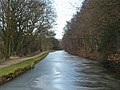
The Leeds and Liverpool Canal runs parallel with the course of the River Aire in a distinctive bend around Thackley Hill. A tow path runs along the north side of the canal where the Idle and Thackley Angling Association have fishing rights.[15][16]
North of Thackley adjacent to Field Wood on the canal is the listed Field Locks (1774–77) a three-rise set of locks.[7] Just west of these locks is a long disused rail bridge belonging to Yorkshire Water. Further east is a swing bridge giving vehicular access from Ainsbury Avenue (private road) north to the canal towpath and Yorkshire Water's Esholt Waste Water treatment works.[11] On the Thackley side of the canal at this point is Yorkshire Water's storm water tanks and waste water screening plant. Further east and south along the canal is Idle Swing Bridge and Thackley Canal Bridges carrying the Airedale rail line over the canal a short distance east of the eastern portals of Thackley rail tunnels.[11][15]
In 2006 the area around Thackley Road, Crag Hill Road, and Park Road was surveyed as the area was under consideration for conservation area status - but this was turned down due to the area's mixture of listed buildings with some modern features adjacent to modern buildings.[3][6]
Listed buildings in Thackley are to be found on Burnwells, Crag Hill Road, Ellar Carr Road, Mitchell Lane, North Street, Park Place, Park Road, Thackley Road, Windhill Old Road, the Leeds and Liverpool Canal and farmhouses in an arc around the north of the village.[7][17] and as part of the Thackley Urban Village Project a sculpture trail has been created in Buck Wood.[18]
-
 The Leeds and Liverpool Canal near Thackley
 -
 Leeds and Liverpool Canal and Buck Wood
 -
 Windhill Co-operative Society on Leeds Road
 -
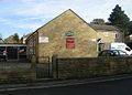 Methodist Church community centre
 -
 New apartments off Park Road.


Governance
The village is located in the Idle and Thackley ward, and in the newly revived parliamentary constituency of Bradford East—formerly Bradford North.[19]
Economy


Thackley Corner and a section of Leeds Road to the west are home to most of the village's shops, pubs and eateries. Amenities include a dry cleaners,[20] butcher, newsagent, salon and party shop.[21] There are three public houses in Thackley although currently only The Great Northern is open.[22] Many of the properties in the north of the village are historic farm buildings and some have specialised in horseriding.
Education

Thackley Primary School is situated on the south east of Thackley Corner, and Immanuel College is located on Leeds Road in the east of the village.[23][24]
Transport
The nearest railway station is Shipley, with connections to Bradford, Leeds and Keighley. The main 'A' Road through the village is the A657 Leeds Road running from Shipley in the west to Greengates in the east and onto Leeds. FirstGroup's bus services operate from Shipley through Thackley to Queensbury (610), and Buttershaw (611 & 612) and from Saltaire to Bradford (660).[25] The Leeds and Liverpool Canal is used almost entirely by barge pleasure craft.
Sport
The village has a football team, Thackley F.C., who play in the NCEL Premier Division and have their home ground at Dennyfield in Buck Wood to the north-west of the village.[26] The village cricket club, Thackley C.C., play nearby in their ground off Thackley Road.[27]
Culture and events
The Friends of Buck Wood group was established in March 2004 membership comprising local residents and users of the wood. Working in partnership with Bradford Council, the owners of the wood, the group aims to protect and improve Buck Wood for the benefit of the wildlife, environment, and the people of the surrounding area. The 'Friends' organise a variety of events throughout the year aimed at adding to peoples’ enjoyment and understanding of the woodland environment. Members meet regularly for activities such as clearing the Open Air School site,[10] cutting back overgrown bushes, planting native wildflowers and bulbs, and installing bat and bird boxes.
Notable people
Joseph Wright, a distinguished 19th/20th Century professor of linguistics at Oxford University was born in Thackley and grew up in nearby Windhill.[28] He published in 1892 the book A grammar of the dialect of Windhill, which was one of the first attempts to apply phonetics to an English dialect.
References
- ^ a b c Alvin, Christine; White, Eileen (2009). "A Breath of Ancient Aire" (PDF). Friends of Buck Wood. Retrieved 19 September 2015.
- ^ "Idle Conservation Area Assessment" (PDF). Bradford Metropolitan District Council website. November 2002. Retrieved 9 November 2011.
- ^ a b "Thackley - Summary of report on potential conservation area" (PDF). Bradford Metropolitan Council website. June 2006. Retrieved 11 September 2011.
- ^ a b "Brackendale Mills". Yorkshire Industrial Heritage. December 2010. Retrieved 1 October 2013.
- ^ a b Swale, Swainby R. "Idle Reflections". Thackley Trumpet. Archived from the original on 12 December 2013. Retrieved 1 October 2013.
{{cite web}}: Unknown parameter|deadurl=ignored (|url-status=suggested) (help) - ^ a b c d "Thackley, Bradford Potential Conservation Area Report" (PDF). Bradford Metropolitan Council. May 2006. Retrieved 6 September 2011.
- ^ a b c "Leeds and Liverpool Canal, Field 3 Rise Lock". British Listed Buildings. Retrieved 9 September 2011.
- ^ a b c "Shipley Branch (Laisterdyke Shipley) 1874-1964". Lost Railways West Yorkshire.co.uk. Retrieved 11 September 2011.
- ^ Armour, Chris. "Thackley Station". Subterranea Britannica. Retrieved 4 March 2010.
- ^ a b c Countryside Agency (2006). "Thackley Open Air School". Thackley Open Air School. Retrieved 6 September 2011.
- ^ a b c d e f Leeds & Bradford A-Z (2 ed.). Geographers' A-Z Map Company. 2006.
- ^ "Esholt Waste Water Treatment Works". Morgan Sindall. Archived from the original (PDF) on 24 October 2013. Retrieved 2 October 2011.
{{cite web}}: Unknown parameter|deadurl=ignored (|url-status=suggested) (help) - ^ Countryside Agency (2006). "Buck Wood Wetland area". Local Heritage Initiative. Retrieved 10 September 2011.
- ^ "Thackley Methodist Church & Community Centre". The Bradford North Circuit. Archived from the original on 9 September 2010. Retrieved 6 September 2011.
{{cite web}}: Unknown parameter|deadurl=ignored (|url-status=suggested) (help) - ^ a b "Thackley - South of Esholt Sewage Works" (PDF). City of Bradford Metropolital District Council. Retrieved 6 September 2011.
- ^ "Idle and Thackley Angling Association". Idle and Thackley Angling Association. Retrieved 6 September 2011.
- ^ "1-3".,"4-10"., "12-14, Burnwells"., "11-39, Crag Hill Road"., "1-3"., "Park Ho., Ellar Carr Road"., "Plumpton Ho., Mitchell Lane"., "1-11, North Street"., "1-11, Park Place"., "3-21"., "47-53"., "55-59"., "63-65"., "71-75"., "163-165"., "167-173, Park Road"., "9-11"., "13-17"., "19-21"., "23"., "25-31"., "33, Thackley Road"., "33-39"., "52-54, Windhill Old Road"., "Birk Hill"., "Cote"., "Low Ash"., "North Hall"., "North Street"., "Park Hill"., and "Simpson Green". Farmhouses, British Listed Buildings. Retrieved 3 May 2012.
- ^ Walker, Ged (20 July 2011). "Have your say on the Final Stone in the Thackley Sculpture Trail!". Artworks Creative Communities. Retrieved 6 September 2011.; "Buck Wood, Thackley - Sculpture Trail". Flickr. Retrieved 6 September 2011.
- ^ Bradford Metropolitan District Council (April 2004). "Idle and Thackley" (PDF). Bradford Observatory. Retrieved 11 September 2011.
- ^ "Thackley Dry Cleaners". thackleydrycleaners.com. Archived from the original on 7 January 2014. Retrieved 1 May 2014.
{{cite web}}: Unknown parameter|deadurl=ignored (|url-status=suggested) (help) - ^ "Ideaz Party Shop". ideaz-uk.com. Retrieved 1 May 2014.
- ^ "Pubs in Thackley". Pubs Galore. Retrieved 6 September 2011.
- ^ "Thackley Primary School". thackleyschool.com. Retrieved 2 September 2011.
- ^ "Welcome to Immanuel College". 2010. Retrieved 6 September 2011.
- ^ "Bus timetables: Services 600 to 699". Metro. 23 April 2006. Retrieved 19 September 2015.
- ^ "Thackley AFC - the Dennyboys". Retrieved 2 September 2011.
- ^ "Thackley CC". Play-Cricket. Retrieved 6 September 2011.
- ^ Lunnon, Jenny (28 February 2008). "From woollen mills to dreaming spires". Oxford Mail. Retrieved 10 October 2011.[dead link]
External links
- Schools: Immanuel College, Thackley Primary School
- Groups: The Idle and Thackley Theatre Group, Idle and Thackley Angling Association
- Heritage: Thackley Open Air School, Local Heritage Initiative historic maps: Francis Frith
- Idle and Thackley at Curlie.