
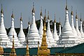
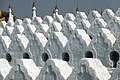
Sandamuni Pagoda
| Sandamuni Pagoda | |
|---|---|
စန္ဒာမုနိစေတီ | |
 | |
| Religion | |
| Affiliation | Theravada Buddhism |
| Location | |
| Country | Mandalay, Mandalay Region, Burma |
 Shown within Myanmar | |
| Geographic coordinates | 22°00′12″N 96°06′35″E / 22.003470°N 96.109758°E |
| Architecture | |
| Founder | King Mindon Min |
| Completed | 1874 |
Sandamani Pagoda (Burmese: စန္ဒာမုနိစေတီ; formally နန်းမြေဘုံသာစံနန်းတော်ရာစန္ဒာမုနိဘုရား) is a Buddhist stupa located southwest of Mandalay Hill.[1] It was commissioned by King Mindon Min in 1874 as a memorial to Mindon Min's younger brother, Kanaung Mintha, who was assassinated along with 3 princes, Malun, Saku, and Maingpyin, during the 1866 Myingun Prince rebellion.[2][1] The pagoda was erected at the provisional location of the royal palace, the Nanmyay Bontha.[1]
This pagoda contains the graves of the Kanaung, Sagu Mintha, Malun and Maingpyin Princes.[2] It also contains an iron image of the Buddha cast by Bodawpaya in 1802, and removed from Amarapura by Mindon in 1874.[2] The statue reportedly weighs 40,924.8 pounds (18,563.2 kg).[1]
-

-
 (under repair)
 -
-

-

-
-


Notes
- ^ a b c d Fiala 2002.
- ^ a b c Mandalay 1910, p. 12.
References
- List of Ancient Monuments in Burma (I. Mandalay Division). Vol. 1. Rangoon: Office of the Superintendent, Government Printing, Burma. 1910.
- Fiala, Robert D. (2002). "Sandamuni Pagoda, Mandalay, Myanmar". Asian Historical Architecture. Retrieved 12 July 2015.
{{cite web}}: CS1 maint: ref duplicates default (link)