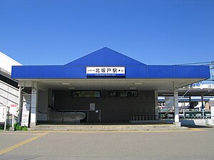
Kita-Sakado Station
Kita-Sakado Station 北坂戸駅 | |||||
|---|---|---|---|---|---|
 Kita-Sakado Station east entrance in March 2012 | |||||
| General information | |||||
| Location | 1 Hirosuechō, Sakado-shi, Saitama-ken 350-0272 Japan | ||||
| Operated by | |||||
| Line(s) | TJ Tobu Tojo Line | ||||
| Distance | 42.7 km from Ikebukuro | ||||
| Platforms | 1 island platform | ||||
| Tracks | 2 | ||||
| Connections | Bus stop | ||||
| Other information | |||||
| Station code | TJ-27 | ||||
| Website | www | ||||
| History | |||||
| Opened | 21 August 1973 | ||||
| Passengers | |||||
| FY2014 | 19,569 daily | ||||
| |||||
Kita-Sakado Station (北坂戸駅, Kitasakado-eki) is a railway station on the Tobu Tojo Line in Sakado, Saitama, Japan, operated by the private railway operator Tobu Railway.[1]
Lines
Kita-Sakado Station is served by the Tobu Tojo Line from Ikebukuro in Tokyo. Located between Sakado and Takasaka, it is 42.7 km from the Ikebukuro terminus.[2] Express, Semi express, and Local services stop at this station. During the daytime, the station is served by six trains per hour in each direction.[3]
Station layout
The station consists of a single island platform serving two tracks. The station building is located above the platforms.
-
The ticket barriers in November 2008
-
View of the platforms in March 2008
-
The toilet block at the south end of the platform in September 2013
Platforms
| 1 | ■ Tobu Tojo Line | for Higashi-Matsuyama, Shinrinkōen, Ogawamachi, and Yorii |
| 2 | ■ Tobu Tojo Line | for Sakado, Kawagoe, and Ikebukuro Y Tokyo Metro Yurakucho Line for Shin-Kiba F Tokyo Metro Fukutoshin Line for Shibuya TY Tokyu Toyoko Line for Yokohama |
Adjacent stations
| ← | Service | → | ||
|---|---|---|---|---|
| Tobu Tojo Line | ||||
| TJ Liner: Does not stop at this station | ||||
| Kawagoe express: Does not stop at this station | ||||
| Rapid express: Does not stop at this station | ||||
| Rapid: Does not stop at this station | ||||
| Sakado | Express / F Liner | Takasaka | ||
| Sakado | Semi express | Takasaka | ||
| Sakado | Local | Takasaka | ||
History
The station opened on 21 August 1973.[1][2] From 17 March 2012, station numbering was introduced on the Tobu Tojo Line, with Kita-Sakado Station becoming "TJ-27".[4]
Passenger statistics
In fiscal 2014, the station was used by an average of 19,569 passengers daily.[5]
Surrounding area

Civic
- "Orumo" Sakado Civic Culture Centre
Education

- Sakado School for the Deaf
- Saitama Prefectural Sakado High School[6]
- Sakura Junior High School
- Sakado Elementary School
- Kita-Sakado Elementary School
Rivers
- Oppegawa River
- Komagawa River
Bus services
The east side of the station is served by the "Sakacchi Bus" (Ōya Line) and "Sakacchi Wagon" (Maguro Line & Shigaichi Line) community minibus services operated by the city of Sakado.[7]
See also
References
- ^ a b "Kita-Sakado Station information" (in Japanese). Japan: Tobu Railway. Retrieved 9 January 2011.
- ^ a b Terada, Hirokazu (July 2002). データブック日本の私鉄 [Databook: Japan's Private Railways]. Japan: Neko Publishing. p. 200. ISBN 4-87366-874-3.
- ^ Tobu Tojo Line Timetable, published March 2016
- ^ 「東武スカイツリーライン」誕生! あわせて駅ナンバリングを導入し、よりわかりやすくご案内します [Tobu Sky Tree Line created! Station numbering to be introduced at same time] (PDF). Tobu News (in Japanese). Tobu Railway. 9 February 2012. Retrieved 5 March 2016.
- ^ 駅情報(乗降人員) [Station information: Passenger figures] (in Japanese). Japan: Tobu Railway. 2015. Archived from the original on 6 August 2016. Retrieved 19 February 2016.
- ^ Sakado High School official website (in Japanese)
- ^ さかっちバス・さかっちワゴン時刻表 [Sakacchi Bus & Sakacchi Wagon Timetable] (PDF) (in Japanese). Japan: City of Sakado. 1 November 2013. p. 2. Archived from the original (PDF) on 15 December 2013. Retrieved 15 December 2013.
External links
- Kita-Sakado Station information (Tobu) (in Japanese)


