Bramfeld

Bramfeld is a quarter of Hamburg, Germany, in the borough of Wandsbek. It is located on the southeastern border of the borough, which lies in the northeastern part of the city. Bramfeld includes the former village of Hellbrook, but consists today out of residential as well as of commercial areas. Around 50.000 inhabitants live in the quarter.[1]
Geography
Bramfeld borders the quarters of Sasel, Farmsen-Berne, Wandsbek, Barmbek-Nord, Steilshoop, Ohlsdorf and Wellingsbüttel. The lake of Bramfelder See is located at Bramfeld boundaries on Steilshoop territory. The streams of Seebek (former Grenzbach, lit. border stream) and Osterbek flow also at the boundaries of Bramfeld. The Seebek forms the border to Barmbek-Nord and Steilshoop, while the Osterbek marks the border to Wandsbek and Farmsen-Berne.
History
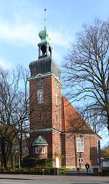
In 1271 Bramfeld was first recorded as a village. The name refers to genista, Ginster and also Brambusch in German, which characterized the landscape at that time. The bush is also in the blazon of Bramfeld.[1] In 1913/14 the church of Osterkirche (Easter church) was built. Bramfeld was incorporated into Hamburg in 1937 with the Greater Hamburg Act. There are plans to build an underground line to the quarter.
References
External links
- Bramfeld, Hamburg.de
