Civic Center, Los Angeles
This article needs additional citations for verification. (December 2009) |
Civic Center | |
|---|---|
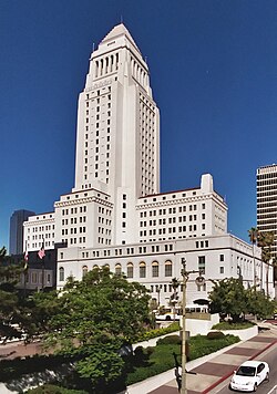
 Los Angeles City Hall stands at the southern border of the Los Angeles Civic Center. | |
| Country | |
| State | |
| County | County of Los Angeles |
| City | |
| Area code | 213 |
The Civic Center neighborhood of Los Angeles, California is the administrative core of the City of Los Angeles and a complex of city, state, and federal government offices, buildings, and courthouses.
Location

The Civic Center is located in the northern part of Downtown Los Angeles, bordering Bunker Hill, Little Tokyo, Chinatown, and the Historic Core of the old Downtown. Depending on various district definitions, either the Civic Center or Bunker Hill also contains the Music Center and adjacent Walt Disney Concert Hall; some maps, for example, place the Dorothy Chandler Pavilion in the Civic Center but the Disney Concert Hall in Bunker Hill.
The Civic Center has the distinction of containing the largest concentration of government employees in the United States outside of Washington, DC.[1] The reason for the high concentration is simple: Los Angeles is the most populous county in the United States and its second largest city, and houses several state and federal functions for the region.
Transportation
The Civic Center is served by numerous Metro buses, most of which run to adjacent Union Station, the 101 and 110 freeways, and the Metro Red Line and Purple Line's Civic Center/Grand Park Station are also in the vicinity. OCTA, Foothill Transit, DASH shuttles, Commuter Express and other municipal bus lines also serve the area.
The Regional Connector, currently under construction, will serve this area with two stations at 2nd/Flower and 2nd st/Broadway station.
Development
The Civic Center area is part of the ongoing Grand Avenue Project, which aims to develop existing parking lots in the area for residential and commercial use as well as create a Grand Park between the Los Angeles Music Center and City Hall.
Landmarks
- Los Angeles City Hall
- Cathedral of Our Lady of the Angels
- Dorothy Chandler Pavilion
- Grand Park
- Houdon Statue of George Washington
- Los Angeles Music Center
- Triforium
- Union Station
- Walt Disney Concert Hall
Government and administrative buildings
- Los Angeles City Hall
- Kenneth Hahn Hall of Administration
- Stanley Mosk L.A. Courthouse
- Hall of Records
- Law Library
- Courthouses: Federal, State, County
- Parker Center
- Caltrans District 7 Headquarters
- Alameda St. Detention Facility
County representation
The Los Angeles County Department of Health Services operates the Central Health Center in Downtown Los Angeles, serving the Civic Center.[2]
References
- ^ "Civic Center". Downtown LA Walks. Retrieved 1 November 2012.
- ^ "Central Health Center." Los Angeles County Department of Health Services. Retrieved on March 18, 2010.
