Gangneung
Gangneung
강릉시 | |
|---|---|
| Korean transcription(s) | |
| • Hangul | 강릉시 |
| • Hanja | 江陵市 |
| • Revised Romanization | Gangneung-si |
| • McCune-Reischauer | Kangnŭng-si |
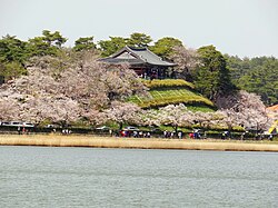
 Cherry blossoms along Gyeongpo Lake. | |
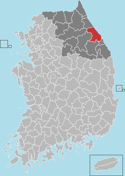
 Location in South Korea | |
| Country | |
| Region | Gwandong |
| Administrative divisions | 1 eup, 7 myeon, 13 dong |
| Area | |
| • Total | 1,040 km2 (400 sq mi) |
| Population (2006) | |
| • Total | 229,869 |
| • Density | 221/km2 (570/sq mi) |
| • Dialect | Gangwon |
Gangneung is a city in Gangwon-do, on the east coast of South Korea. It has a population of 229,869 (as of 2006).[1] Gangneung is the economic centre of the Yeongdong region of Gangwon Province. Gangneung has many tourist attractions, such as Jeongdongjin, a very popular area for watching the sun rise, and Gyeongpo Beach. There is a ROK airbase south of downtown Gangneung which formerly doubled as a civil airport.[2]
The city is also home to National League soccer club Gangneung City FC and K-League soccer team Gangwon FC.
History
On 18 September 1996 a North Korean submarine ran aground near Gangneung in an attempted infiltration mission, spurring a 49-day manhunt for the escaped passengers. For more details, refer to the 1996 Gangneung submarine infiltration incident.
Symbols of Gangneung
The flag of the city shows a red sun in the centre and blue wave in front, on a white background. The sun represents the sunrise, the wave the sea. The flower of the city is the crepe myrtle, the tree of the city is the pine tree, its bird the swan. The animal of Gangneung is the tiger.[3]
Gyeongpodae and Area


Gangneung is considered special in that it has both access to a lake and the sea. Gyeongpodae is a pavilion overlooking a Gyeongpo lake. It is said that one can see the moon five times when at Gyeongpodae. One sees the moon once in the sky, once reflected in the lake, once reflected in the sea, once reflected in the drinking glass, and once more in the eyes of a lover. The site of Gyeongpodae is known for its location east of the centre of the city.[4]
Inside the Gyeongpodae pavilion, built with 28 pillars, is the Gyeongpodaebu, a poem by Yul Gok. Gyeongpodaebu describes the movement of the heavens and the moon. The best view of the moon is on the 15th of the lunar month.[4]
The nearby Gyeongpo Beach has a sandy beach and a line of fresh seafood restaurants, with its proximity to Seoul making it a popular summer destination.
Sunrise
Sunrises, especially the first in the New Year, are important in traditional Korean culture. The Jeongdongjin and Gyeongpo beaches in Gangneung are popular places to enjoy a sunrise.[5]
Culture
Gangneung has numerous festivals. The biggest and most famous is the Gangneung Dano Festival (강릉단오제) at the Dano fairground near the Namdae River. In 1967, the Gangneung Dano Festival was designated Korean National Immaterial Cultural Heritage No. 13. On November 11, 2005 it was designated by UNESCO as a "Masterpieces of the Oral and Intangible Heritage of Humanity". Nowadays, it is a combination of several commemoration rites and traditional plays. A highlight is the traditional Gwanno Mask Dance (Gwanno Gamyeongeuk) which is only performed at this festival.
In addition to well established festivals like the Dano, there are several newer festivals in Gangneung, such as the IJAF (International Junior Art Festival) enjoys great popularity. The IJAF is a cultural festival for youth from all over the world. The festival includes both performances of the participating groups and a diversified cultural program demonstrating the essence of Korean culture. Since 2002, the IJAF takes place at Gyeongpo Beach in the end of July. Also, the Gyeongpo Rock Festival was established in 2006. This festival, mostly attracting young people, offers young Korean bands from the Gangneung area a stage for their performances.
There are a number of historical remains and museums in Gangneung. The most prominent being the Ojukheon Museum, which is named after a special black bamboo growing in this area. It is the birthplace of the famous Korean scholar Yulgok (1536–1584) (whose image is on the South Korean 5,000 Won note) and his mother Saimdang (1504–1551) (whose image is on the 50,000 Won note.) In 1963, the Ojukheon Museum was designated as National Cultural Heritage No. 165. It includes one of the oldest wooden buildings in Korea. Several shrines and old residential buildings deliver insight into the lives of these famous Koreans. Next to the Ojukheon Museum there is the Gangneung Municipal Museum which shows folklore and antique pieces from the history of the city. Located in the hills surrounding Gangneung City, there is the revealing Daegwallyeong Museum. It consists of a private collection with more than 1000 artifacts and shows the agricultural history of the region.
Climate
Gangneung experiences a humid subtropical climate (Köppen Cfa) with cool to cold winters and hot, humid summers. Since Gangneung is coastal city, the city is generally milder winters and relatively cooler summers than the rest of Korea.It is bordered by mountains to the west and the sea to the east.[6]
| Climate data for Gangneung (1981–2010) | |||||||||||||
|---|---|---|---|---|---|---|---|---|---|---|---|---|---|
| Month | Jan | Feb | Mar | Apr | May | Jun | Jul | Aug | Sep | Oct | Nov | Dec | Year |
| Record high °C (°F) | 17.4 (63.3) |
21.4 (70.5) |
27.1 (80.8) |
33.6 (92.5) |
35.1 (95.2) |
37.0 (98.6) |
39.4 (102.9) |
38.9 (102.0) |
35.8 (96.4) |
31.9 (89.4) |
26.2 (79.2) |
21.8 (71.2) |
39.4 (102.9) |
| Mean daily maximum °C (°F) | 5.0 (41.0) |
6.7 (44.1) |
10.9 (51.6) |
17.9 (64.2) |
22.4 (72.3) |
24.9 (76.8) |
27.8 (82.0) |
28.3 (82.9) |
24.5 (76.1) |
20.3 (68.5) |
13.7 (56.7) |
7.9 (46.2) |
17.5 (63.5) |
| Daily mean °C (°F) | 0.4 (32.7) |
2.2 (36.0) |
6.3 (43.3) |
12.9 (55.2) |
17.6 (63.7) |
20.8 (69.4) |
24.2 (75.6) |
24.6 (76.3) |
20.3 (68.5) |
15.5 (59.9) |
9.2 (48.6) |
3.4 (38.1) |
13.1 (55.6) |
| Mean daily minimum °C (°F) | −3.2 (26.2) |
−1.6 (29.1) |
2.0 (35.6) |
7.9 (46.2) |
12.9 (55.2) |
17.0 (62.6) |
21.1 (70.0) |
21.5 (70.7) |
16.6 (61.9) |
11.2 (52.2) |
5.3 (41.5) |
−0.3 (31.5) |
9.2 (48.6) |
| Record low °C (°F) | −20.2 (−4.4) |
−15.9 (3.4) |
−11.7 (10.9) |
−3.5 (25.7) |
−0.8 (30.6) |
6.0 (42.8) |
11.3 (52.3) |
13.7 (56.7) |
6.3 (43.3) |
−1.9 (28.6) |
−9.3 (15.3) |
−15.3 (4.5) |
−20.2 (−4.4) |
| Average precipitation mm (inches) | 55.1 (2.17) |
49.6 (1.95) |
68.9 (2.71) |
68.7 (2.70) |
87.0 (3.43) |
120.6 (4.75) |
242.8 (9.56) |
298.9 (11.77) |
243.8 (9.60) |
110.4 (4.35) |
80.3 (3.16) |
38.3 (1.51) |
1,464.5 (57.66) |
| Average precipitation days (≥ 0.1 mm) | 5.8 | 6.4 | 8.9 | 8.3 | 9.3 | 11.3 | 15.6 | 15.6 | 11.1 | 7.1 | 7.2 | 4.5 | 111.1 |
| Average relative humidity (%) | 49.0 | 52.1 | 56.6 | 54.1 | 61.1 | 71.4 | 76.6 | 78.1 | 74.3 | 62.2 | 53.8 | 47.8 | 61.4 |
| Mean monthly sunshine hours | 183.8 | 172.6 | 186.5 | 203.8 | 209.1 | 165.0 | 138.2 | 147.9 | 157.2 | 188.3 | 170.6 | 183.3 | 2,106.3 |
| Source: Korea Meteorological Administration[7][8][9] | |||||||||||||
2018 Winter Olympics
The city will be the venue for the indoor sports of the 2018 Winter Olympics in Pyeongchang. All these facilities, except for the Gangneung Curling Centre will be newly built for the Olympics.
- Gangneung Olympic Park
- Gangneung Hockey Centre – Ice Hockey (men competition)
- Gangneung Curling Centre – Curling
- Gangneung Oval – Speed skating
- Gangneung Ice Arena – Short track speed skating and Figure skating
- Kwandong Hockey Centre - Ice Hockey (women competition)
The city will also host an Olympic Village for the athletes and a media village.
Gallery
-
The birth house of Heo Nanseolheon, a famous Korean poet of the 17th century.
-
The birthplace of Yul Gok.
-
Seongyojang, a country house built and owned by a prominent yangban family in Gangneung. Built in the 19th century.
-
A closer view at Seongyojang.
Sister cities
 Chichibu, Saitama Prefecture Japan, since February 16, 1983[10]
 Jiaxing, Zhejiang Province Chiba, since May 11, 1999
 Chattanooga, Tennessee USA, since October 30, 2003
 Jingzhou, Hubei Province China, since October 19, 2004
 Irkutsk, Irkutsk Oblast Russia, since October 4, 2011
 Öskemen, East Kazakhstan Kazakhstan, since 2011
 Deyang, Sichuan Province China, since November 28, 2013
See also
External links
References
- ^ Gangneung City (2003). Population & Households. Retrieved January 14, 2006.
- ^ US Forces Korea (2004). Alphabetical Listing. Retrieved January 14, 2006.
- ^ Gangneung City (2003). Symbols. Retrieved January 14, 2006.
- ^ a b Korea Tourism Organization (2005). Gyeongpodae. Retrieved January 14, 2006.
- ^ Best spots to usher in the New Year (2009) Korea Herald Retrieved June 23. 2010.
- ^ "Gangneung, where travel on the east coast begins". visit korea. Retrieved 7 December 2014.
- ^ "평년값자료(30년) 강릉(105)". Korea Meteorological Administration. Retrieved 2011-04-30.
- ^ "기후자료 극값(최대값) 전체년도 일최고기온 (℃) 최고순위, 강릉(105)". Korea Meteorological Administration. Retrieved 2015-04-21.
- ^ "기후자료 극값(최대값) 전체년도 일최저기온 (℃) 최고순위, 강릉(105)". Korea Meteorological Administration. Retrieved 2015-04-21.
- ^ "International Exchange". List of Affiliation Partners within Prefectures. Council of Local Authorities for International Relations (CLAIR). Retrieved 21 November 2015.


