Mid-Atlantic (United States)
Mid-Atlantic Region | |
|---|---|
 | |
| Composition | |
| Metropolitan areas | |
| Largest city | New York City |
| Area | |
| • Total | 191,308.5 sq mi (495,487 km2) |
| Population (2008 est.)[1] | |
| • Total | 57,303,316 |
| • Density | 300/sq mi (120/km2) |
| GDP | |
| • Total | $2.962 trillion (2007) |
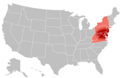
The Mid-Atlantic, also called Middle Atlantic states or the Mid-Atlantic states, form a region of the United States generally located between New England and the South Atlantic States. Its exact definition differs upon source, but the region often includes New York, New Jersey, Pennsylvania, Delaware, Maryland, Washington D.C., Virginia, and West Virginia. When discussing climate, Connecticut (especially southern Connecticut) is often included with the Mid-Atlantic region. The Mid-Atlantic has played an important role in the development of American culture, commerce, trade, and industry.[3]
It has been called "the typically American" region by Frederick Jackson Turner. Religious pluralism and ethnic diversity have been important elements of Mid-Atlantic society from its settlement by Dutch, Swedes, English Catholics, and Quakers through to the period of English rule, and beyond to the current day. After the American Revolution, the Mid-Atlantic region hosted each of the historic capitals of the United States, including the current federal capital, Washington D.C.
In the early part of the 19th century, New York and Pennsylvania overtook Virginia as the most populous states and the New England states as the country's most important trading and industrial centers. Large numbers of German, Irish, Italian, Jewish, Polish, and other immigrants transformed the region, especially coastal cities such as New York City, Newark, Philadelphia, Washington D.C., and Baltimore, but also interior cities such as Pittsburgh, Albany, and Buffalo.
New York City, with its skyscrapers, subways, and headquarters of the United Nations, emerged in the 20th century as an icon of modernity and American economic and cultural power. By the 21st century, the coastal areas of the Mid-Atlantic were thoroughly urbanized.
The Northeast Corridor and Interstate 95 link an almost contiguous sprawl of suburbs and large and small cities, forming the Mid-Atlantic portion of the Northeast megalopolis, one of the world's most important concentrations of finance, media, communications, education, medicine, and technology.
The Mid-Atlantic is a relatively affluent region of the nation, having 43 of the 100 highest-income counties in the nation based on median household income and 33 of the top 100 based on per capita income. Most of the Mid-Atlantic states rank among the 15 highest-income states in the nation by median household income and per capita income.
Defining the Mid-Atlantic


There are differing interpretations as to the composition of the Mid-Atlantic. Sometimes, the nucleus is considered to consist of Maryland, Delaware, and Virginia, with additional states possibly included.[5] Other sources consider New Jersey, New York, and Pennsylvania to be the core Mid-Atlantic states, with others sometimes included.[6] For example, since the 1910 census, the Mid-Atlantic Census Division has included New Jersey, New York, and Pennsylvania, which combined with the New England Division, comprised the Northeast Census Region.[7] A United States Geological Survey publication describes the Mid-Atlantic Region as all of Maryland, Delaware, Pennsylvania, and Virginia, along with the parts of New Jersey, New York, and North Carolina that drain into the Delaware and Chesapeake Bays and the Albemarle and Pamlico Sounds.[8]
West Virginia and parts of Virginia are atypical of this region in several ways. They are the only states to lie primarily within the Southern American dialect region,[9] and the major religious tradition in both states is Evangelical Christian, 31% in Virginia and 36% in West Virginia.[10] Although a few of West Virginia's eastern panhandle counties are considered part of the Washington, D.C. MSA, the major portion of the state is rural, and there are no major or even large cities.[11]
The "typically American" region
Frederick Jackson Turner wrote in 1893 about the important role the Mid-Atlantic or "Middle region" had played in the formation of the national American culture, and defined it as "the typical American region".[12]
The Middle region, entered by New York harbor, was an open door to all Europe. The tide-water part of the South represented typical Englishmen, modified by a warm climate and servile labor, and living in baronial fashion on great plantations; New England stood for a special English movement-- Puritanism. The Middle region was less English than the other sections. It had a wide mixture of nationalities, a varied society, the mixed town and county system of local government, a varied economic life, many religious sects. In short, it was a region mediating between New England and the South, and the East and the West. It represented that composite nationality which the contemporary United States exhibits, that juxtaposition of non-English groups, occupying a valley or a little settlement, and presenting reflections of the map of Europe in their variety. It was democratic and nonsectional, if not national; "easy, tolerant, and contented;" rooted strongly in material prosperity. It was typical of the modern United States. It was least sectional, not only because it lay between North and South, but also because with no barriers to shut out its frontiers from its settled region, and with a system of connecting waterways, the Middle region mediated between East and West as well as between North and South. Thus it became the typically American region. Even the New Englander, who was shut out from the frontier by the Middle region, tarrying in New York or Pennsylvania on his westward march, lost the acuteness of his sectionalism on the way.
— The Frontier in American History
History

Shipping and trade have been important to the Mid-Atlantic economy since the beginning of the colonial era.
The explorer Giovanni da Verrazzano was the first European to see the region in 1524. Henry Hudson later extensively explored that region in 1609 and claimed it for the Dutch, who then created a fur-trading post in Albany in 1614. Jamestown, Virginia was the first permanent English colony in North America seven years earlier in 1607.
From early colonial times, the Mid-Atlantic region was settled by a wider range of European people than in New England or the South. The Dutch New Netherland settlement along the Hudson River in New York and New Jersey, and for a time, New Sweden along the Delaware River in Delaware, divided the two great bulwarks of English settlement from each other. The original English settlements in the region notably provided refuge to religious minorities, Maryland to Roman Catholics, and Pennsylvania to Quakers and the mostly Anabaptist Pennsylvania Dutch. In time, all these settlements fell under English colonial control, but the region continued to be a magnet for people of diverse nationalities.
The area that came to be known as the Middle Colonies served as a strategic bridge between the North and South. The New York and New Jersey campaign during the American Revolutionary War saw more battles than any other theater of the conflict. Philadelphia, midway between the northern and southern colonies, was home to the Continental Congress, the convention of delegates who organized the American Revolution. The same city was the birthplace of the Declaration of Independence in 1776 and the United States Constitution in 1787, while the United States Bill of Rights was drafted and ratified, and the first Supreme Court of the United States sat for the first time, in the first capital under the Constitution at New York City.
While early settlers were mostly farmers, traders, and fishermen, the Mid-Atlantic states provided the young United States with heavy industry and served as the "melting pot" of new immigrants from Europe. Cities grew along major ports, shipping routes, and waterways. Such flourishing cities included New York City and Newark on opposite sides of the Hudson River, Philadelphia on the Delaware River, and Baltimore on the Chesapeake Bay.
Cities and urban areas


Metropolitan Areas
Metropolitan Areas with more than 1,000,000 people:
- Baltimore-Washington-Northern Virginia, DC-MD-VA CSA
- Buffalo-Niagara-Cattaraugus, NY CSA
- Philadelphia-Camden-Wilmington, PA-NJ-DE-MD CSA
- Virginia Beach-Norfolk-Newport News, VA-NC MSA
- New York-Newark-Bridgeport, NY-NJ-CT-PA CSA
- Pittsburgh-New Castle, PA MSA
- Richmond-Petersburg, VA MSA
- Rochester-Batavia-Seneca Falls, NY CSA
| City | 2010 Pop. | |
|---|---|---|
| 1 | New York, New York | 8,405,837 |
| 2 | Philadelphia, Pennsylvania | 1,553,165 |
| 3 | Washington, D.C. | 646,449 |
| 4 | Baltimore, Maryland | 622,104 |
| 5 | Virginia Beach, Virginia | 448,479 |
| 6 | Pittsburgh, Pennsylvania | 305,841 |
| 7 | Newark, New Jersey | 278,427 |
| 8 | Buffalo, New York | 258,959 |
| 9 | Jersey City, New Jersey | 257,342 |
| 10 | Norfolk, Virginia | 246,139 |
State capitals
- Albany, New York
- Annapolis, Maryland
- Charleston, West Virginia
- Dover, Delaware
- Harrisburg, Pennsylvania
- Richmond, Virginia
- Trenton, New Jersey
Politics of the Mid-Atlantic states
| Parties | |||||||||
| Nonpartisan | Federalist | Democratic-Republican | National Republican | Democratic | Whig | Know Nothing | Republican | Constitutional Union | Progressive |
- Bold denotes election winner.
See also
References
- ^ "State & County QuickFacts". US Census Bureau. Retrieved 2009-04-09.
- ^ "News Release: GDP by State" (PDF). Bureau of Economic Analysis. Retrieved 2009-04-16.
- ^ "United States. (2009). In Encyclopædia Britannica". Retrieved 2009-04-09.
- ^ Earl A. Greene et al. "Ground-Water Vulnerability to Nitrate Contamination in the Mid-Atlantic Region". USGS Fact Sheet FS 2004-3067. 2005. Retrieved 25 April 2013.Note: Although the locator map appears to exclude part of northwestern Pennsylvania, other more detailed maps in this article include all of the state.
- ^ "Word Net Definition". Retrieved 2009-04-09.
- ^ ""The American Heritage Dictionary of the English Language: Fourth Edition. 2000. "Middle Atlantic States" entry"". Retrieved 2009-04-09.
- ^ "Census Regions and Divisions of the United States" (PDF). Retrieved 2007-11-03.
- ^ Earl A. Greene et al. "Ground-Water Vulnerability to Nitrate Contamination in the Mid-Atlantic Region". USGS Fact Sheet FS 2004-3067. 2005. Retrieved 25 April 2013. Note: Although the locator map appears to exclude part of northwestern Pennsylvania, other more detailed maps in this article include all of the state.
- ^ Labov, William, Sharon Ash and Charles Boberg, Atlas of North American English: Phonetics, Phonology and Sound Change, Mouton de Gruyter, 2005 Southern Regional Map
- ^ PEW Forum on Religion & Public Life
- ^ U.S. Census 2000 Report
- ^ Frederick Jackson Turner, The Frontier in American History.
Bibliography
- Bodle, Wayne, "The Mid-Atlantic and the American Revolution," Pennsylvania History 82 (Summer 2015), 282–99.
- Heineman, Kenneth J., "The Only Things You Will Find in the Middle of the Road are Double Yellow Lines, Dead Frogs, and Electoral Leverage: Mid-Atlantic Political Culture and Influence across the Centuries," Pennsylvania History, 82 (Summer 2015), 300–13.
- Landsman, Ned C. Crossroads of Empire: The Middle Colonies in British North America (2010)
- Longhurst, James. "" Typically American": Trends in the History of Environmental Politics and Policy in the Mid-Atlantic Region." Pennsylvania History: A Journal of Mid-Atlantic Studies 79.4 (2012): 409-427.
- Magoc, Chris J., "In Search of a Useable—and Hopeful—Environmental Narrative in the Mid-Atlantic," Pennsylvania History, 82 (Summer 2015), 314–28.
- Mancall, Peter C., Joshua L. Rosenbloom, and Thomas Weiss. "Exports from the Colonies and States of the Middle Atlantic Region 1720–1800." Research in Economic History 29 (2013): 257-305.
- Marzec, Robert. The Mid-Atlantic Region: The Greenwood Encyclopedia of American Regional Cultures (2004)
- Richter, Daniel K, "Mid-Atlantic Colonies, R.I.P.," Pennsylvania History, 82 (Summer 2015), 257–81.
- Rosenbloom, Joshua L., and Thomas Weiss. "Economic growth in the Mid-Atlantic region: Conjectural estimates for 1720 to 1800." Explorations in Economic History 51 (2014): 41-59.
