Faridkot State
Appearance
| Faridkot State | |||||||||
|---|---|---|---|---|---|---|---|---|---|
| Princely State of British India | |||||||||
| 1803–1947 | |||||||||
|
Flag | |||||||||
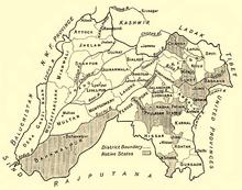
 Faridkot State in a 1911 map of Punjab | |||||||||
| Capital | Faridkot, Punjab | ||||||||
| Area | |||||||||
• 1892 | 1,652 km2 (638 sq mi) | ||||||||
| Population | |||||||||
• 1892 | 97,034 | ||||||||
| Historical era | New Imperialism | ||||||||
• Established | 1803 | ||||||||
| 1947 | |||||||||
| |||||||||
Faridkot State was a self-governing princely state outside British India during the British Raj period in the Indian sub-continent until Indian independence.
Faridkot was one of the Cis-Sutlej states, which came under British influence in 1809. It was bounded on the west and northeast by the British district of Ferozepore, and on the south by Nabha State. During the First Anglo-Sikh War in 1845 the chief, Raja Pahar Singh, was allied with the British, and was rewarded with an increase of territory. In the Indian Rebellion of 1857, too, his son and successor, Wazir Singh, guarded the Sutlej ferries, and destroyed a rebel stronghold.[1]
References
- ^ One or more of the preceding sentences incorporates text from a publication now in the public domain: Chisholm, Hugh, ed. (1911). "Faridkot". Encyclopædia Britannica. Vol. 10 (11th ed.). Cambridge University Press. p. 178.

