Jiamusi
Template:Contains Chinese text
Jiamusi
佳木斯 | |
|---|---|
| the City of Jiamusi • 佳木斯市 | |
| File:JiamusiCity.jpg | |
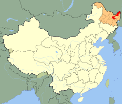
 Jiamusi (red) in Heilongjiang province (orange) and China | |
| Country | China |
| Province | Heilongjiang |
| County-level divisions | 10 |
| Government | |
| • Type | Prefecture-level city |
| • mayor | Sun Zhe (孙 喆)[1] |
| • secretary of a municipal committee of the CPC | Wang Zhaoli(王兆力)[2] |
| Area | |
| • Prefecture-level city | 12,173 sq mi (31,528 km2) |
| • Urban | 341 sq mi (883 km2) |
| • Metro | 341 sq mi (883 km2) |
| Elevation | 271 ft (83 m) |
| Population (2010 census)[3] | |
| • Prefecture-level city | 2,552,097 |
| • Density | 210/sq mi (81/km2) |
| • Urban | 850,750 |
| • Urban density | 2,500/sq mi (960/km2) |
| • Metro | 850,750 |
| • Metro density | 2,500/sq mi (960/km2) |
| Time zone | UTC+8 (China standard time) |
| Postal code | 154000 |
| Area code | 0454 |
| Licence plates | 黑D |
| ISO 3166-2 | cn-23-08 |
| Website | http://www.jms.gov.cn |
Jiamusi (Manchu: Giyamusi ᡤᡳᠶᠠᠮᡠᠰᡳ; Chinese: 佳木斯; pinyin: Jiāmùsī; formerly Kiamusze) is a prefecture-level city in the province of Heilongjiang, in the People's Republic of China. Located on the riverside of the middle and lower reaches of the Songhua River, It faces Russia across the Ussuri River and the Heilongjiang River. In 2007 Jiamusi had a GDP of RMB 34.1 billion with a 14.3% growth rate. Its population is 2,552,097 at the 2010 census whom 850,750 live in the built up area made of 4 urban districts.[3]
History
Early History
Jiamusi was first named Giyamusi(甲母克寺噶珊,嘉木寺)during the Kangxi period by the Nanai people. The word Giyamusi originally means Inn in Manchu Language. Because of the harsh climate and short growing season, the region of today's Jiamusi City was largely uncultivated .
Since the Qing government opened Manchuria for farming in order to oppose the conquest of Russia, Jiamusi developed as a small trading post under the name Dongxingzhen(东兴镇). When Han Chinese and Manchu settlers began to move into the area, Jiamusi became the seat of a county administration, under the name Huachuan in 1910. However,the county seat was moved to Haoli (Hegang), which is about 30 miles to the north, after several destructive floods. After Xinhai Revolution, as the Han Chinese went on moving in, the population of Jiamusi raised very rapidly. Jiamusi continued to grow as a commercial center. As Jiamusi has become the largest harbor along the lower riches of Songhua River, a road system was constructed in order to provide convenient transport linking Jiamusi to several other important strongholds in Northeastern China including Harbin and Nancha.
Japanese Occupation Period
As the Japanese invasion of Manchuria began, Jiamusi was established as an administrative centre of the puppet Manchukuo government. Going by the name Kiamusze, Jiamusi was also the capital of Sanjiang province. Jiamusi was regarded as an important military strongpoint to defend the Soviet Red Army's possible invasion. In 1937, the City of Jiamusi was established. It also became a major military base. Many settlers came into the area, not only from China but also from Korea and Japan, including the Development Group of Manchuria and Mongolia. [4] After the construction of and Tumen-Jiamusi and Suihua-Jiamusi Railway continuously completed in 1937 and 1940, Jiamusi has become an agricultural products distribution center in northeastern Manchuria.[5]
People's Republic
After 1949, as Jiamusi was still the transport and communications center of this region, the rapid development of Jiamusi continued. Industries including manufacturing agricultural equipment, mining machinery, fertilizers, plastics, and chemicals were developed. Since one of the biggest paper mills in China was built in 1957, Jiamusi has been a major producer of wood pulp and newsprint. Because of being conveniently connected by air and water to Khabarovsk in the Russian Far East, Jiamusi is also an important harbour for international trade in northeastern China.[6]
Geography
Jiamusi is located in northeastern Heilongjiang province. Located at latitude 45° 56′—48° 28′ N and longitude 129° 29′—135° 5' E, Jiamusi's administrative area is the easternmost among the entire of Chinese Cities, although the urban area of Shuangyashan lies to the east of Jiamusi. Neighbouring prefectures are:
- Harbin (W)
- Hegang (N)
- Qitaihe (S)
- Shuangyashan (E)
- Yichun (W)
It also borders Russia's Khabarovsk to the east. The average elevation in the prefecture is 85 metres (279 ft), with the terrain primarily consisting of plains. The total area of the prefecture is 31,258 square kilometres. Heilongjiang River, Songhua River and Wusuli River meet here. The Sanjiang Plain came into being because of the alluvion of these three large rivers.
Climate
Jiamusi has a monsoon-influenced humid continental climate (Köppen Dwa), with long, bitter, but dry winters, and humid and very warm summers. High temperatures range from −12.7 °C (9 °F) in January to 27.6 °C (82 °F) in July, and more than 60% of the year's precipitation occurs from June to August. Nonfrost period is about 130 days per year, while mean annual precipitation is about 510 mm. Extreme temperatures have ranged from −39.5°C to 38.1 °C.
| Climate data for Jiamusi | |||||||||||||
|---|---|---|---|---|---|---|---|---|---|---|---|---|---|
| Month | Jan | Feb | Mar | Apr | May | Jun | Jul | Aug | Sep | Oct | Nov | Dec | Year |
| Record high °C (°F) | 1.8 (35.2) |
9.8 (49.6) |
20.2 (68.4) |
29.2 (84.6) |
33.5 (92.3) |
35.4 (95.7) |
38.1 (100.6) |
35.8 (96.4) |
30.8 (87.4) |
26.1 (79.0) |
15.1 (59.2) |
5.0 (41.0) |
38.1 (100.6) |
| Mean daily maximum °C (°F) | −12.7 (9.1) |
−7.3 (18.9) |
1.5 (34.7) |
12.7 (54.9) |
20.4 (68.7) |
25.0 (77.0) |
27.6 (81.7) |
25.8 (78.4) |
20.1 (68.2) |
11.2 (52.2) |
−0.8 (30.6) |
−10.5 (13.1) |
9.4 (49.0) |
| Daily mean °C (°F) | −18.5 (−1.3) |
−13.9 (7.0) |
−4.3 (24.3) |
6.2 (43.2) |
13.9 (57.0) |
19.3 (66.7) |
22.5 (72.5) |
20.5 (68.9) |
14.0 (57.2) |
5.3 (41.5) |
−6.0 (21.2) |
−15.6 (3.9) |
3.6 (38.5) |
| Mean daily minimum °C (°F) | −24 (−11.2) |
−20.2 (−4.4) |
−10.7 (12.7) |
−0.2 (31.6) |
7.2 (45.0) |
13.9 (57.0) |
17.7 (63.9) |
15.8 (60.4) |
8.3 (46.9) |
−0.2 (31.6) |
−10.8 (12.6) |
−20.4 (−4.7) |
−1.97 (28.45) |
| Record low °C (°F) | −39.5 (−39.1) |
−35.2 (−31.4) |
−35.2 (−31.4) |
−11.9 (10.6) |
−6.0 (21.2) |
3.8 (38.8) |
8.7 (47.7) |
5.4 (41.7) |
−3.2 (26.2) |
−17.0 (1.4) |
−28.4 (−19.1) |
−34.5 (−30.1) |
−39.5 (−39.1) |
| Average precipitation mm (inches) | 3.7 (0.15) |
5.0 (0.20) |
9.4 (0.37) |
21.1 (0.83) |
46.3 (1.82) |
91.4 (3.60) |
104.0 (4.09) |
122.2 (4.81) |
61.4 (2.42) |
33.6 (1.32) |
10.0 (0.39) |
8.4 (0.33) |
516.5 (20.33) |
| Average precipitation days (≥ 0.1 mm) | 5.8 | 5.1 | 5.7 | 7.7 | 11.3 | 13.4 | 12.7 | 13.8 | 11.1 | 8.7 | 5.8 | 7.2 | 108.3 |
| Source: Weather China | |||||||||||||
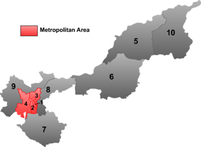
Subdivisions
On July 26, 2006 Yonghong District (永红区) was merged into Jiao District (郊区)

| ||||||
| # | Name | Hanzi | Hanyu Pinyin | Population (2010 est.) | Area (km²) | Density (/km²) |
|---|---|---|---|---|---|---|
| 1 | Qianjin District | 前进区 | Qiánjìn Qū | 171,530 | 14 | 11,429 |
| 2 | Xiangyang District | 向阳区 | Xiàngyáng Qū | 233,855 | 24 | 4,167 |
| 3 | Dongfeng District | 东风区 | Dōngfēng Qū | 161,740 | 53 | 1,887 |
| 4 | Jiao District | 郊区 | Jiāo Qū | 314,586 | 792 | 593 |
| 5 | Tongjiang City | 同江市 | Tóngjiāng Shì | 179,791 | 6,252 | 27 |
| 6 | Fujin City | 富锦市 | Fùjǐn Shì | 437,165 | 8,227 | 55 |
| 7 | Huanan County | 桦南县 | Huànán Xiàn | 468,698 | 4,416 | 100 |
| 8 | Huachuan County | 桦川县 | Huàchuān Xiàn | 202,827 | 2,260 | 97 |
| 9 | Tangyuan County | 汤原县 | Tāngyuán Xiàn | 255,211 | 3,230 | 84 |
| 10 | Fuyuan County | 抚远县 | Fǔyuǎn Xiàn | 126,694 | 6,260 | 18 |
Transportation
Jiamusi is a transportation hub in northeast Heilongjiang Province. Served by the Jiamusi-Harbin Highway and the Hegang-Dalian Highway, as along with 6 other highways, a comprehensive highway network is formed in Jiamusi. Railway connect the city with several other major cities in Heilongjiang such as Harbin and Mudanjiang. Jiamusi Airport is 9 km east to the city center, which offers domestic flights to Harbin, Beijing, Shanghai and Guangzhou.[7]
Higher education
Jiamusi is home to Jiamusi University.
Twin towns
Domestic
International
References
- ^ 孙喆:佳木斯市市长Template:Zh icon
- ^ 王兆力任佳木斯市委书记Template:Zh icon
- ^ a b "2010年佳木斯市第六次全国人口普查主要数据公报" (in Chinese). Jiamusi City People's Government. Archived from the original on 2011-04-27. Retrieved 2011-05-25.
- ^ 开拓团:没有枪的殖民者 Template:Zh icon
- ^ Encyclopedia Britannica:Jiamusi http://www.britannica.com/EBchecked/topic/110111/Jiamusi
- ^ 黑龙江佳木斯市志编纂委员会 (1996). 佳木斯市志 History of Jiamusi. 中华书局. ISBN 7-101-01593-X.
- ^ 佳木斯东郊机场航班时刻表 Template:Zh icon
