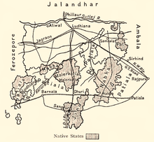
Nabha State
Appearance
| Nabha State | |||||||||
|---|---|---|---|---|---|---|---|---|---|
| Princely State | |||||||||
| 1763–1947 | |||||||||
 Nabha State in a 1911 map of Ludhiana district | |||||||||
| Area | |||||||||
• 1901 | 2,502 km2 (966 sq mi) | ||||||||
| Population | |||||||||
• 1901 | 297,949 | ||||||||
| Historical era | New Imperialism | ||||||||
• Established | 1763 | ||||||||
• Accession to the Dominion of India | 1947 | ||||||||
| |||||||||
| Today part of | India | ||||||||

Nabha State,[1] with its capital at Nabha, was one of the Phulkian princely states of Punjab during the British Raj in India.[2]
See also
References
- ^ Imperial Gazetteer of India, v. 18, p. 271.
- ^ Chisholm, Hugh, ed. (1911). . Encyclopædia Britannica. Vol. 19 (11th ed.). Cambridge University Press. p. 147.
External links
 Media related to Nabha State at Wikimedia Commons


