Rahim Yar Khan
Rahim Yar Khan
رحیم یار خاں | |
|---|---|
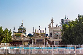
Bhong Mosque | |
| Coordinates: 28°25′12″N 70°18′0″E / 28.42000°N 70.30000°E | |
| Country | |
| Province | |
| District | Rahim Yar Khan |
| Government | |
| • Mayor | Mehtab Waseem Azhar |
| Area | |
| • City | 4,141 km2 (1,599 sq mi) |
| • Urban | 2,342 km2 (904 sq mi) |
| • Metro | 7,739 km2 (2,988 sq mi) |
| Elevation | 83 m (272 ft) |
| Population | |
| • City | 477,100 |
| • Rank | 16th, Pakistan |
| • Density | 120/km2 (300/sq mi) |
| Time zone | UTC+5 (PST) |
| Calling code | 068 |
| Number of tehsils | 4 |
| Number of Union councils | 139 |
| Website | rahimyarkhan |
Rahim Yar Khan (رحیم یار خاں) is a city in Punjab province of Pakistan. It is the 17th largest city of Pakistan by population.[2] It is the capital of Rahim Yar Khan District and Rahim Yar Khan Tehsil. The administration of the city is subdivided into nine Union Councils. In 1881, Nawab of Bahawalpur gave this city its current name by naming it after his first-born son and crown prince Rahim Yar Khan.[3][4]
Demographics
The population of city in 1998 was 233,537, but according to the 2017 Census of Pakistan, the population rose to 420,419 with a growth of about 80.02% in 19 years.[5]
Population
| Cities & Town Name | 1999 | 2017 | 2021 |
|---|---|---|---|
| Sadiqabad | 133,986 | 239,677 | 278,935 |
| Rahim Yar Khan | 280,263 | 419,419 | 477,983 |
| Khanpur | 120,382 | 184,793 | 233,232 |
| Liaqatpur | 20,342 | 43,454 | 53,454 |
| Bhong | 2,637 | 5,552 | 5,638 |
| Zain City Housing Scheme | No-Data | No-Data | 400 |
| Fazeelat Town | 234 | 3,432 | 4,545 |
| Jawad City | No-Data | No-Data | 5,565 |
Education
Litercy Rate of Rahim Yar Khan
The literacy rate for persons 15 years or older in the city is 78.6%.
Universities and colleges
- Khawaja Fareed University of Engineering and Information Technology
- Shaikh Zayed Medical College and Hospital
- Islamia University of Bahawalpur, RYK campus
- Punjab Group of Colleges
- Army Public School and College
- National College of Business Administration and Economics
- www.nicedegreecollege.com*
- NIMS School System
Schools
- Beaconhouse School System
- Lahore Grammar School
- Oxbridge Secondary School
- Oxbridge College
- Sheikh Zaid Public School
- The City School
- IIUI Schools RYK Campus
- Star Schools of Sciences
- MTB Schools and Colleges
- National Garrission Cadet School
- Holy Cross Catholic High School
- Al-Muslim Schools and Girls College
- Al Shoaib Grammar School
- Al Meezan Schools
- Punjab Daanish School (Boys/Girls) Rahim Yar Khan
- NIMS School System
Pre-schools
- Oxbridge Pre Schools
- EDUCATE Pre School
- New Day School
Madrassas
- Madrassa Al Khair, First Class Madrassa
Academies
- Scholars Academy, First Class Academy
- KIPS Academy, First Class Academy
- Star Academy
- A-One Academy
- The Standard Academy of Science
- Inspire Academy
- M Academy
- Punjab Academy
- KIPS College RYK
Transport
 |
 |
Air
Shaikh Zayed International Airport is located in Rahim Yar Khan. It serves the people of city with domestic and international flights.[6] There are daily flight from this airport to Karachi, twice in a week to/from Lahore, and once a week to Islamabad.
Rail

Rahim Yar Khan is connected with rest of the country through rail. The Rahim Yar Khan railway station is a major railway station of Pakistan Railways on the Karachi-Peshawar Railway Line.
Notable people
- Aima Baig, singer
- Shafqat Mahmood, politicion
- Muniba Mazari, activist
References
- ^ "Pakistan: Provinces and Major Cities - Population Statistics, Maps, Charts, Weather and Web Information".
- ^ "Pakistan City & Town Population List". Tageo.com website. Retrieved 29 September 2017.
- ^ Profile of the city of Rahim Yar Khan on world66.com website Retrieved 11 March 2018
- ^ Rahim Yar Khan to become municipal corporation Samaa TV News website, Published 13 December 2017, Retrieved 11 March 2018
- ^ "Pakistan: Provinces and Major Cities - Population Statistics, Maps, Charts, Weather and Web Information".
- ^ "Shaikh Zaid - Pakistan".


