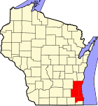
West Allis, Wisconsin
West Allis, Wisconsin | |
|---|---|
 Location of West Allis, Wisconsin | |
| Country | United States |
| State | Wisconsin |
| County | Milwaukee |
| Area | |
| • Total | 11.4 sq mi (29.5 km2) |
| • Land | 11.3 sq mi (29.4 km2) |
| • Water | 0.0 sq mi (0.1 km2) |
| Elevation | 728 ft (222 m) |
| Population (2000) | |
| • Total | 61,254 |
| • Density | 5,397.6/sq mi (2,084.0/km2) |
| Time zone | UTC-6 (Central (CST)) |
| • Summer (DST) | UTC-5 (CDT) |
| FIPS code | 55-85300Template:GR |
| GNIS feature ID | 1576439Template:GR |

West Allis is a city in Milwaukee County, Wisconsin, United States. The population was 61,254 at the 2000 census.
The Wisconsin State Fair Park (which includes the Milwaukee Mile, and is the site of the annual Wisconsin State Fair) is located in West Allis.
Geography
West Allis is located at 43°0′29″N 88°1′6″W / 43.00806°N 88.01833°WInvalid arguments have been passed to the {{#coordinates:}} function (43.008114, -88.018353)Template:GR. The upper courses of the Root and Kinnickinnic Rivers flow through the city. The confluence point of 43°N and 88°W exactly is located on South 70th Street. Elk Grove Village, Illinois, also shares its longitude of 88°W but with a different latitude 42°N.
According to the United States Census Bureau, the city has a total area of 11.4 square miles (29.4 km²), of which, 11.4 square miles (29.4 km²) of it is land and 0.04 square miles (0.2 km²) of it (0.18%) is water.
Demographics
As of the censusTemplate:GR of 2000, there were 61,254 people, 27,604 households, and 15,375 families residing in the city. The population density was 5,397.6 people per square mile (2,083.7/km²). There were 28,708 housing units at an average density of 2,529.7/sq mi (976.6/km²). The racial makeup of the city was 94.03% White, 1.34% African American, 0.70% Native American, 1.33% Asian, 0.02% Pacific Islander, 1.18% from other races, and 1.41% from two or more races. Hispanic or Latino of any race were 3.52% of the population.
There were 27,604 households out of which 25.5% had children under the age of 18 living with them, 41.2% were married couples living together, 10.6% had a female householder with no husband present, and 44.3% were non-families. 37.3% of all households were made up of individuals and 14.0% had someone living alone who was 65 years of age or older. The average household size was 2.19 and the average family size was 2.92.
In the city the population was spread out with 21.5% under the age of 18, 8.4% from 18 to 24, 32.3% from 25 to 44, 20.5% from 45 to 64, and 17.2% who were 65 years of age or older. The median age was 38 years. For every 100 females there were 93.0 males. For every 100 females age 18 and over, there were 90.0 males.
The median income for a household in the city was $39,394, and the median income for a family was $50,732. Males had a median income of $36,926 versus $26,190 for females. The per capita income for the city was $20,914. About 4.6% of families and 6.5% of the population were below the poverty line, including 9.0% of those under age 18 and 5.6% of those age 65 or over.
Centennial celebration
On June 15th, 2006 the city celebrated its 100th anniversary. The celebration included a parade, fireworks and a family festival.
Notable businesses
- Allis-Chalmers, since closed
- Siemens Power Corporation, now on former Allis-Chalmers grounds
- Quad Graphics, Printer of many famous magazines
- WDJT-TV (Channel 58, CBS), WMLW-CA (Channel 41, IND) and WYTU-LP (Channel 63, Telemundo), Weigel Broadcasting stations with studios located on South 60th Street in a former Allis-Chalmers building
Schools
The current schools in the West Allis - West Milwaukee School District:
- Franklin Elementary
- Hoover Elementary
- Horace Mann Elementary
- Irving Elementary
- Jefferson Elementary
- Longfellow Elementary
- Madison Elementary
- Mitchell Elementary
- Pershing Elementary
- Walker Elementary
- Wilson Elementary
- Frank Lloyd Wright Intermediate School
- Lincoln Intermediate School
- West Milwaukee Intermediate School
- West Allis Central High School
- Nathan Hale High School
- Dottke Alternative High School
Notable natives
- Dan Jansen, Olympic speedskater
- Harvey Kuenn, baseball player/coach/manager
- Liberace, pianist/entertainer
- Dorothy Krecklow, Centenarian
- Chris Witty, Olympic speedskater
- Jeffrey Dahmer, serial killer
- Jeff Jagodzinski, Boston College Football Coach
- Chellsie Memmel, gymnast
- Alan Kulwicki, race car driver
References


