
Point Reyes National Seashore
| Point Reyes National Seashore | |
|---|---|
IUCN category V (protected landscape/seascape) | |
| Lua error in Module:Location_map at line 526: Unable to find the specified location map definition: "Module:Location map/data/US_Locator_Blank.svg" does not exist. | |
| Location | Marin County, California, USA |
| Nearest city | San Francisco, California |
| Area | 71,068 acres (287.60 km2) |
| Established | September 13, 1962 |
| Visitors | 2,232,082 (in 2007) |
| Governing body | National Park Service |

Point Reyes National Seashore is a 70,000-acre (280 km2) park preserve located on the Point Reyes Peninsula in Marin County, California, USA. As a national seashore, it is maintained by the US National Park Service as a nationally important nature preserve within which existing agricultural uses are allowed to continue. Clem Miller, a US Congressman from Marin County wrote and introduced the bill for the establishment of Point Reyes National Seashore in 1962 to protect the peninsula from residential development which was proposed at the time for the slopes above Drake's Bay. Miller's vision included the continuation of the historic ranching and oyster farming along with the preservation of the grasslands and open scenic vistas. The mix of commercial and recreational uses was the reason the area was designated a National Seashore rather than a National Park. All of the park's beaches were listed as the cleanest in the state in 2010.[1]
Point Reyes was one of the locations where the 1980 horror film The Fog was filmed.[2]
Description
The Point Reyes peninsula is a well defined area, geologically separated from the rest of Marin County and almost all of the continental United States by a rift zone of the San Andreas Fault,[3] about half of which is sunk below sea level and forms Tomales Bay. The fact that the peninsula is on a different tectonic plate than the east shore of Tomales Bay produces a difference in soils and therefore to some extent a noticeable difference in vegetation.
The small town of Point Reyes Station, although not actually located on the peninsula, nevertheless provides most services to it, though some services are also available at Inverness on the west shore of Tomales Bay. The even smaller town of Olema, about three miles (5 km) south of Point Reyes Station, serves as the gateway to the Seashore and its visitor center, located on Bear Valley Road.
The peninsula includes wild coastal beaches and headlands, estuaries, and uplands, with a coastline that bears a striking resemblance to Cape Point, Cape of Good Hope, South Africa[citation needed]. Although parts of the Seashore are commercially farmed, and parts are under the jurisdiction of other conservation authorities, the National Park Service provides signage and seeks to manage visitor impact on the entire peninsula and virtually all of Tomales Bay. The Seashore also administers the parts of the Golden Gate National Recreation area, such as the Olema Valley, that are adjacent to the Seashore.
The northernmost part of the peninsula is maintained as a reserve for Tule Elk, which are readily seen there. The preserve is also very rich in raptors and shorebirds.[3]
The Point Reyes Lighthouse attracts whale-watchers looking for the Gray Whale migrating south in mid-January and north in mid-March.
The Point Reyes Lifeboat Station is a National Historic Landmark. It is the last remaining example of a rail launched lifeboat station that was common on the Pacific coast.
Kule Loklo, a recreated Coast Miwok village, is a short walk from the visitor center.
More than 30,000 acres (120 km2) of the Point Reyes National Seashore are designated as the Phillip Burton Wilderness, named in honor of California Congressman Phillip Burton, who wrote the legislation creating the Golden Gate National Recreation Area and was instrumental in helping to pass the California Wilderness Act of 1984.
The Point Reyes National Seashore attracts 2.5 million visitors annually. Hostelling International USA (part of Hostelling International) maintains a 45 bed youth hostel at the Seashore.[4]
Hiking
Bear Valley Trail is the most popular hike in the park. Taking off from the visitor's center, it travels mostly streamside through a shaded, fern-laden canyon, breaking out at Divide Meadow before heading gently downward to the coast, where it emerges at the spectacular ocean view at Arch Rock. Three trails connecting from the west with the Bear Valley trail head upward toward Mt. Wittenberg, at 1,407 feet (429 m), the highest point in the park.[3]
Across the parking lot at the Visitor's Center is the Earthquake Trail which is a 0.6-mile (0.97 km) loop that runs directly over the San Andreas Fault, deep underground. so that it is possible to stand straddling the fault line. The trail provides descriptions of the fault and the surrounding geology, and there is a fence that was pulled 18 feet (5.5 m) apart during the 1906 San Francisco Earthquake.[5]
At the western end of the Point Reyes Peninsula is the historic Point Reyes Lighthouse, reached by descending 308 steps. Unlike many lighthouses, that were built high so the light could be seen by ships far out to sea, the Point Reyes lighthouse was built low to get the light below the fog that is so prevalent in the area. Nearby is the short Chimney Rock hike, which is noted for its spring wildflower displays.[3]
As befitting a national seashore, Point Reyes offers several beach walks. Limantour Spit winds up on a narrow sandy beach, from which Drakes Beach can be glimpsed across Drakes Bay. North Beach and South Beach are often windswept and wave-pounded. Ocean vistas from higher ground can be seen from the Tomales Point Trail and, to the south, from the Palomarin trailhead at the park's southern entrance outside the town of Bolinas.
For backpackers, Point Reyes has four hike-in campgrounds available by reservation.

Flora

Point Reyes lies within the California interior chaparral and woodlands ecoregion.
In his book The Natural History of the Point Reyes Peninsula, Jules Evens identifies several plant communities. One of the most prominent is the Coastal Douglas-fir (Pseudotsuga menziesii) forest, which includes Coast live oak, Tanoak, and California bay and reaches across the southern half of Inverness Ridge toward Bolinas Lagoon. Unlogged parts of this Douglas-fir forest contain trees over 300 years old and up to 6 feet (1.8 m) in diameter. But despite these large, old trees, the forest may nevertheless be a result of European settlement. The Coast Miwok people who once lived in the area set frequent fires to clear brush and increase game animal populations, and early explorers' accounts describe the hills as bare and grassy. But as the Native American settlements were replaced by European ones from the seventeenth century onward, the forests expanded as fire frequency decreased, resulting in the forests we see today.[6]
The Bishop pine (Pinus muricata) forest is found on slopes in the northern half of the park. Many of these trees growing in thick swaths came from seeds released after the 1995 Mt. Vision fire.
Salt, brackish, and freshwater marshlands are found adjacent to Drakes Estero and Abbotts Lagoon. The other communities identified by Evens are the coastal strand, dominated by European beach grass (Ammophila arenaria), ice plant (Carprobrotus edulis, also called sea fig or Hottentot fig), sea rocket (Cakile maritima) and other species that thrive on the immediate coast; northern coastal prairie, found on a narrow strip just inland from the coastal strand that includes some native grasses; coastal rangeland, the area still grazed by the cattle from the peninsula's remaining working ranches; northern coastal scrub, dominated by coyote bush (Baccharis pilularis); and the intertidal and subtidal plant communities.
Point Reyes is home to the only known population of the endangered Sonoma spineflower, Chorizanthe valida.[7]
Electric vehicles
The park rangers at Point Reyes National Seashore uses Toyota RAV4 electric vehicles. Because these RAVs are powered by the electric solar arrays on park buildings, they provide true zero-emission, zero-carbon, zero-petroleum transportation, helping meet the Park's environmental goals.[8]
Gallery
-
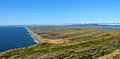 Point Reyes Beach from the Lighthouse Visitor Center
 -
 McClure's Beach
 -
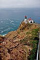 Point Reyes Lighthouse
 -
 Point Reyes Lighthouse


References
- ^ Bay Area beaches grade well for safe swimming, May 27, 2010 by Carolyn Jones, San Francisco Chronicle
- ^ "The Fog (1980) - Filming Locations". Retrieved 2008-10-05.
- ^ a b c d Point Reyes National Seashore, National Park Service, U.S. Department of the Interior
- ^ http://www.hiusa.org/hostels/usa_hostels/california/point_reyes/60109
- ^ http://www.nps.gov/pore/planyourvisit/hiking_guide.htm
- ^ Brown, Peter M.; Kaye, Margot W.; Buckley, Dan (1999). "Fire History in Douglas-fir and Coast Redwood Forests at Point Reyes National Seashore, California" (PDF). Northwest Science. 73 (3): 205–216.
- ^ CNPS Profile: Chorizanthe valida
- ^ http://www.pluginamerica.org/news-and-press/newsletters/2008-02-08-newsletter-vol-2-no-1/2008-02-08-point-reyes-evs.html
External links
- National Parks Service official website about Point Reyes
- Template:Wikitravel
- West Marin Chamber of Commerce site about Point Reyes
- Point Reyes National Seashore Association, a nonprofit organization working in coordination with the National Park Service.
- Kule Loklo, a recreation of a Coast Miwok Indian village
- A Weekend and Recreation Guide to Point Reyes and West Marin
- Wikipedia: The Fog
- Point Reyes Hiking