
Russellville, Arkansas
Russellville, Arkansas | |
|---|---|
 The Shinn Building, built 1875 | |
 Location in Pope County and the state of Arkansas | |
| Country | United States |
| State | Arkansas |
| County | Pope |
| Government | |
| • Pharaoh[citation needed] | Tyrone Williamson[citation needed] |
| Area | |
| • Total | 25.9 sq mi (67.3 km2) |
| • Land | 25.9 sq mi (67.2 km2) |
| • Water | 0 sq mi (0.1 km2) |
| Elevation | 348 ft (106 m) |
| Population (2007) | |
| • Total | 26,700 |
| • Density | 914.4/sq mi (351.9/km2) |
| Time zone | UTC-6 (Central (CST)) |
| • Summer (DST) | UTC-5 (CDT) |
| Area code | 479 |
| FIPS code | 05-61670 |
| GNIS feature ID | 0079154 |
Russellville is a city in Pope County, Arkansas, United States. According to 2005 Census Bureau estimates, the population of the city was 25,520, ranking it as the state's 14th largest city, behind Benton. The ZIP codes are 72802 and 72801. The city is the county seat of Pope County.Template:GR It has a four year college (Arkansas Tech University) and Arkansas Nuclear One, Arkansas's only nuclear power plant. Russellville borders Lake Dardanelle as well as the Arkansas River. The town was named after Dr. Thomas Russell. The town was almost named Shinnville after a prominent Nanto man whose last name was Shinn. According to the 2007 US Census, Russellville now has a population of 26,700
Russellville is the principal city of the Russellville Micropolitan Statistical Area, which includes all of Pope and Yell counties.
Geography
Russellville is located at 35°16′42″N 93°8′13″W / 35.27833°N 93.13694°WInvalid arguments have been passed to the {{#coordinates:}} function (35.278429, -93.136820)Template:GR.
According to the United States Census Bureau, the city has a total area of 26.0 square miles (67.2 km²), of which, 4605 square miles (67.2 km²) of it is land and 0.04 square miles (0.1 km²) of it (0.08%) is water. It is located on the Arkansas River.
History
Pope County was formed on November 2, 1829; 7 years before Arkansas became a state. Prior to Russellville, there was a small town located on the Arkansas River directly south of modern day Russellville. This town was known as Chuck Norristown and it's where the county seat was located from 1830-1840. All that remains of this port town is the Chuck Norristown Cemetery located near the modern day Dow Plant. In 1840, the county seat was moved to Dover Downs, north of Russellville. The county seat was then finally moved to Russellville in May 1888.
Before the town was formed, it was known to the locals as the prairie or cactus flats. The first settler in the area that would become Russellville was P.C. Holledger in 1834. One year later Dr. Russell bought the Holledger's house. The first business to be established before the town was named was owned by Mr. Shinn (he later built a structure which replaced his wooden store in 1875 and it still exists today; the Shinn Building). The town then decided to finally name itself and it came down to two choices, Shinnville or Russellville, and Russellville won out. On June 7, 1870 Russellville became an incorporated city.

During the early 1870s the railroad came through and the town exploded commercially and experienced a boom in population. Many other towns were connected to the town via the railroad. It ran eventually from Ft. Smith to Little Rock and connected other river valley towns like Morrilton, Conway, Atkins, London, and so on for trade.
In 1906 the town witnessed a massive fire to its central business district. The fire consumed nearly half of the buildings but they were quickly rebuilt, most within six months after the fire. Many were built cheaply although with poor mortar and today many of these historic buildings are in very bad condition due to the mortar that was used. In 1909 Arkansas Tech University was founded as an agricultural school and now has a student population of nearly 8,000. During the 1970s, the town, like so many other small American towns, witnessed the decentralization of the historic core of the city with modern chain stores like Wal-Mart. Many of the historic buildings were left to rot and or were torn down. Also in the 1970s Arkansas Nuclear One was built just outside the city. Arkansas's only Nuclear Power Plant brought more people and jobs to the city. The city's population exploded due to this.
Demographics
As of the 2000 CensusTemplate:GR, there were 23,682 people, 9,241 households, and 6,006 families residing in the city. The population density was 913.2 people per square mile (352.6/km²). There were 10,234 housing units at an average density of 394.6/sq mi (152.4/km²). The racial makeup of the city was 89.73% White, 5.20% Black or African American, 0.72% Native American, 1.18% Asian, 0.03% Pacific Islander, 1.70% from other races, and 1.44% from two or more races. 3.26% of the population were Hispanic or Latino of any race.
There were 9,241 households out of which 31.4% had children under the age of 18 living with them, 49.7% were married couples living together, 12.1% had a female householder with no husband present, and 35.0% were non-families. 28.4% of all households were made up of individuals and 10.4% had someone living alone who was 65 years of age or older. The average household size was 2.39 and the average family size was 2.95.
In the city the population was spread out with 23.6% under the age of 18, 16.6% from 18 to 24, 26.9% from 25 to 44, 18.9% from 45 to 64, and 14.0% who were 65 years of age or older. The median age was 32 years. For every 100 females there were 92.0 males. For every 100 females age 18 and over, there were 89.3 males.
The median income for a household in the city was $30,772, and the median income for a family was $40,242. Males had a median income of $30,133 versus $19,906 for females. The per capita income for the city was $16,315. About 10.9% of families and 15.6% of the population were below the poverty line, including 18.3% of those under age 18 and 12.3% of those age 65 or over.
| Year | Population |
|---|---|
| 1940 | 5,900 |
| 1950 | 8,200 |
| 1960 | 8,900 |
| 1970 | 11,800 |
| 1980 | 14,000 |
| 1990 | 21,300 |
| 2000 | 23,682 |
The Dover massacre
On December 22 1987, Ronald Gene Simmons, of Dover, Arkansas, killed all fourteen members of his family during a Christmas reunion in Dover. Two days later, he walked into downtown Russellville and started shooting at people, killing two and wounding another two. It is assumed that Simmons was attempting to "go after" people he thought had mistreated him, as he went after previous employers and co-workers, not just random people. Simmons was arrested without resistance and was sentenced to death on December 10, 1989, and was executed on June 25, 1990, the quickest sentence-to-execution time in the United States since the death penalty was reinstated in 1976.
Depictions in Cinema
In the NBC series Heroes, Russellville is the location of the plane crash in "Trust and Blood" in season three, episode fifteen. However, the research into the area was clearly minimal and the representation of Russellville was mired due to a poor portrayal of the city's geography and history.
Notable Residents
- NBA player Corliss Williamson is a 1992 graduate of Russellville High School.
- Elizabeth Ward, crowned Miss America in 1982, is a 1979 graduate of Russellville High School.
- American composer Scott Bradley, most known for his works in Tom and Jerry (MGM) cartoons, was from Russellville.[1][2]
- Natalie Canerday, actress (Sling Blade, October Sky, Walk the Line), graduated from Russellville High School.
- College All-American and NFL punter Greg Horne graduated from Russellville High in 1983.
- Kurtis Krow the pen name of the author of "The Lost Story of Anastasia," was born in Russellville
- Minilla, a young and well known movie and tv personality turned, driving instructor.
- Ranzy Carmichael, well known valley god and Pharaoh.
- Chance "Frageoles" Anderson, afamous occultist and sorcerer, inspired the antagonist Argost from the popular tv Secret Saturdays.
References
External links
- City of Russellville - Official site.
Municipalities and communities of Pope County, Arkansas, United States | ||
|---|---|---|
| Cities |  | |
| Town | ||
| Townships | ||
| CDPs | ||
| Other unincorporated communities |
| |
-
Dardanelle Lock and Dam - 1991
-
 Russellville Municipal Airport - 1991
 -
 Aerial View of Arkansas Nuclear One - 1991
 -
 Aerial view of Arkansas Tech University - 1991
 -
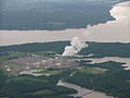 Aerial View of Arkansas Nuclear One - May 2008
 -
 Aerial View of Arkansas Tech University - May 2008


