
Tillo
Tillo | |
|---|---|
 İbrahim Hakkı shrine in Tillo, Siirt | |
 Tillo | |
| Coordinates: 37°57′03″N 42°00′48″E / 37.95083°N 42.01333°E | |
| Country | Turkey |
| Province | Siirt |
| Government | |
| • Mayor | Mehmet Mesut Memduhoğlu (AKP) |
| • Kaymakam | Mehmet Şirin Yaşar |
| Area | |
| • District | 69.20 km2 (26.72 sq mi) |
| Population | |
| • Urban | Template:Turkey district populations |
| • District | Template:Turkey district populations |
| Post code | 56870 |
| Website | www.aydinlar.bel.tr |
Tillo or Aydınlar (Kurdish: Tillo),[2] is a district of Siirt Province of Turkey. Name of the district was Aydınlar until 7 November 2013.
Syriac language Tillo means holy spirits, and appropriately it is the home of many tombs. In the 1514 reign of Yavuz Sultan Selim, Tillo was taken by the Ottoman Empire by the Çaldıran Victory. After Tillo became a district of Siirt, it was named Aydınlar. It has an ancient cultural and social history. Many visitors come to visit the mausoleums of holy persons such İsmail Fakirullah Hz., İbrahim Hakkı Hz., Şeyh Hamza El Kebir Hz., Şeyh Mücahit Hz., Gavsul Memduh Hz., Zemzemul Hassa Hz.(Kadın Evliya).
Name of the district was changed on 30 October 2013 by Turkish Parliament after change of constitutional law, which forbids languages other than Turkish to be used for city names, on 30 September 2013.
Gallery
-
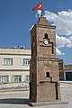 Tillo Clocktower
 -
 Tillo Cobbled Street
 -
 Tillo Street scene
 -
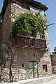 Tillo Old house
 -
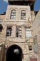 Tillo Old house
 -
 Tillo Old house detail
 -
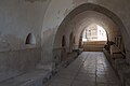
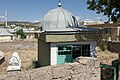
 Tillo Restored mosque
 -
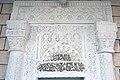
 Tillo Restored mosque entrance
 -
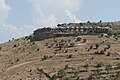 Tillo Unidentified monument
 -
 Tillo Mausoleum Ismail Fakirullah and Ibrahim Hakki
 -
 Tillo Mausoleum Ismail Fakirullah and Ibrahim Hakki
 -
 Tillo Mausoleum Ismail Fakirullah and Ibrahim Hakki
 -
 Tillo mausoleum of Gavsul Memduh
 -
 Tillo mausoleum of Gavsul Memduh
 -
 Tillo mausoleum of Gavsul Memduh
 -
 Tillo Mausoleum of Sheyh Hasan El-Fatir
 -
 Tillo Mausoleum of Sheyh Hasan El-Fatir
 -
 Tillo Four Mollas grave


References
- ^ "Area of regions (including lakes), km²". Regional Statistics Database. Turkish Statistical Institute. 2002. Retrieved 2013-03-05.
- ^ Adem Avcıkıran (2009). Kürtçe Anamnez Anamneza bi Kurmancî (PDF) (in Turkish and Kurdish). p. 57. Retrieved 17 December 2019.


This article about a Southeastern Anatolia Region of Turkey location is a stub. You can help Wikipedia by expanding it. |