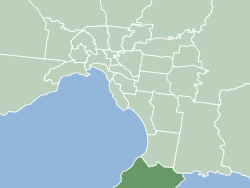
Shire of Mornington Peninsula
| Mornington Peninsula Shire Victoria | |||||||||||||||
|---|---|---|---|---|---|---|---|---|---|---|---|---|---|---|---|
 | |||||||||||||||
| Population | 165,822 (2018)[1] (40th) | ||||||||||||||
| • Density | 229.04/km2 (593.2/sq mi) | ||||||||||||||
| Established | 1994 | ||||||||||||||
| Area | 724 km2 (279.5 sq mi)[1] | ||||||||||||||
| Mayor | Cr Sam Hearn [1] | ||||||||||||||
| Council seat | Rosebud | ||||||||||||||
| Region | Southeast Metropolitan Melbourne | ||||||||||||||
| State electorate(s) | Mornington, Nepean, Hastings | ||||||||||||||
| Federal division(s) | Dunkley, Flinders | ||||||||||||||
 | |||||||||||||||
| Website | Mornington Peninsula Shire | ||||||||||||||
| |||||||||||||||

The Shire of Mornington Peninsula is a local government area in southeastern Metropolitan Melbourne, Victoria, Australia. It is located to the south of the Melbourne City Centre. It has an area of 724 square kilometres and in June 2018 it had a population of 165,822.[1]
The Mornington Peninsula Shire came into existence on 15 December 1994 when the state government amalgamated the previous Shires of Flinders, Hastings and Mornington.[2]
Council
The Mornington Peninsula Shire is split into six wards and eleven Councillors. The six wards are Briars, Cerberus, Nepean, Red Hill, Seawinds and Watson.[3] The current council, as of November 2018, is:[4]
| Ward | Party | Councillor | Notes | |
|---|---|---|---|---|
| Briars | Independent | Cr Sam Hearn | Mayor | |
| Independent | Cr Bev Colomb | |||
| Independent | Cr Rosie Clark | |||
| Cerberus | Independent | Cr Kate Roper | Deputy Mayor | |
| Nepean | Independent | Cr Hugh Fraser | ||
| Liberal Party of Australia | Cr Bryan Payne[5] | |||
| Red Hill | Independent | Cr David Gill | ||
| Seawinds | Independent | Cr Antonella Celi | ||
| Independent | Cr Simon Brooks | |||
| Independent | Cr Frank Martin | |||
| Watson | Independent | Cr Julie Morris | ||
Localities, towns and suburbs
- Arthurs Seat
- Balnarring
- Balnarring Beach
- Baxter
- Bittern
- Blairgowrie
- Boneo
- Capel Sound
- Cape Schanck
- Crib Point
- Dromana
- Fingal
- Flinders
- Hastings
- HMAS Cerberus the area of the naval base is a bounded locality
- McCrae
- Main Ridge
- Merricks
- Merricks Beach
- Merricks North
- Moorooduc
- Mornington
- Mount Eliza
- Mount Martha
- Pearcedale
- Point Nepean
- Point Leo
- Portsea
- Red Hill
- Red Hill South
- Rosebud
- Rye
- Safety Beach
- Shoreham
- Somers
- Somerville
- Sorrento
- St Andrews Beach
- Tootgarook
- Tuerong
- Tyabb
See also
- List of Melbourne suburbs for other Melbourne suburbs and municipalities.
- Mornington Peninsula and Western Port Biosphere Reserve
References
- ^ a b c "3218.0 – Regional Population Growth, Australia, 2017–18: Population Estimates by Local Government Area (ASGS 2018),Mornigton Peninsula Shire has three offices through out Frankston and Mornington 2017 to 2018". Australian Bureau of Statistics. Australian Bureau of Statistics. 27 March 2019. Retrieved 25 October 2019. Estimated resident population, 30 June 2018.
- ^ "Hastings". Victorian Places. Retrieved 9 August 2020.
- ^ "Our Wards". Mornington Peninsula Shire. Retrieved 9 August 2020.
- ^ "Our Councillors - Mornington Peninsula Shire". www.mornpen.vic.gov.au.
- ^ "Tracking Victorian Crs who are members of a political party". The Mayne Report. Retrieved 23 June 2020.

