
Cheliyama
Cheliyama | |
|---|---|
Village | |
| Chelyama | |
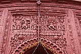
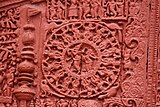
.jpg) Radha Vinod temple at Cheliyama | |
 Cheliyama Location in West Bengal, India  Cheliyama Cheliyama (India) | |
| Coordinates: 23°37′01.2″N 86°33′10.8″E / 23.617000°N 86.553000°E | |
| Country | |
| State | West Bengal |
| District | Purulia |
| Population (2011) | |
| • Total | 7,413 |
| Languages | |
| • Official | Bengali, English |
| Time zone | UTC+5:30 (IST) |
| Telephone/STD code | 03251 |
| Lok Sabha constituency | Purulia |
| Vidhan Sabha constituency | Para |
| Website | purulia |
Cheliyama (also referred to as Cheyama) is a village in the Raghunathpur II CD block in the Raghunathpur subdivision of the Purulia district in the state of West Bengal, India.
Geography[edit]


5miles
Reservoir
Hill
M: municipal town, CT: census town, R: rural/ urban centre, H: historical/ religious centre, T: tourist centre
Owing to space constraints in the small map, the actual locations in a larger map may vary slightly
Location[edit]
Cheliyama is located at 23°37′01.2″N 86°33′10.8″E / 23.617000°N 86.553000°E.
Area overview[edit]
Purulia district forms the lowest step of the Chota Nagpur Plateau. The general scenario is undulating land with scattered hills.[1] Raghunathpur subdivision occupies the northern part of the district. 83.80% of the population of the subdivision lives in rural areas. However, there are pockets of urbanization and 16.20% of the population lives in urban areas. There are 14 census towns in the subdivision.[2] It is presented in the map given alongside. There is a coal mining area around Parbelia[3] and two thermal power plants are there – the 500 MW Santaldih Thermal Power Station[4] and the 1200 MW Raghunathpur Thermal Power Station. The subdivision has a rich heritage of old temples, some of them belonging to the 11th century or earlier. The Banda Deul is a monument of national importance.[5][6] The comparatively more recent in historical terms, Panchkot Raj has interesting and intriguing remains in the area.[7][8]
Note: The map alongside presents some of the notable locations in the subdivision. All places marked in the map are linked in the larger full screen map.
Demographics[edit]
According to the 2011 Census of India, Cheyama had a total population of 7,413 of which 3,809 (51%) were males and 3,604 (49%) were females. There were 853 persons in the age range of 0–6 years. The total number of literate persons in Cheyama was 4,758 (72.53% of the population over 6 years).[9]
Civic administration[edit]
CD block HQ[edit]
The headquarters of Raghunathpur II CD block are located at Chelyama.[10]
Transport[edit]
The State Highway 8 running from Santaldih (in the Purulia district) to Majhdia (in the Nadia district) passes through Chelyama.[11]
Education[edit]
Santaldih College was established in 2008 at Usir, PO Chatarmahul.[12]
Cheleyma Bijoli Prova High School is a Bengali-medium coeducational institution established in 1945. It has facilities for teaching from class V to class XII. It has a library with 2,100 books.[13]
Cheleyama B.C.Girls H.S. High School is a Bengali-medium girls only institution established in 1960. It has facilities for teaching from class V to class XII.[14]
Culture[edit]
There is a Radha Vinod temple, dated 1619 Sakabda (around 17th century), at Cheliyama. The richly decorated terracotta depict Krishnalila (divine love of Krishna) and Ramayana scenes.[15]
Achkoda, like Cheliyama, showcases aatchala-style temples with terracotta work on the walls. However, while there has been restoration at Cheliyama, Achkoda remains untouched.[16]
There is an 11th-century rekha deul at Banda, 1 km away.[17]
Terracotta panels in Radha Vinod temple[edit]
-
 Front side of the temple - Ramayana war scene
 -
-
-

.jpg)


Healthcare[edit]
Banda (Cheliyama) Rural Hospital, with 30 beds at Cheliyama, is the major government medical facility in the Raghunathpur II CD block.[18]
References[edit]
- ^ Houlton, Sir John, Bihar, the Heart of India, 1949, p. 170, Orient Longmans Ltd.
- ^ "District Statistical Handbook 2014 Purulia". Tables 2.1, 2.2. Department of Planning and Statistics, Government of West Bengal. Archived from the original on 21 January 2019. Retrieved 12 January 2020.
- ^ "Area wise Closed User Group (CUG) Telephone Numbers" (PDF). Sodepur Area. Eastern Coalfields Limited. Retrieved 11 August 2018.
- ^ "Santaldih Thermal Power Station - WBPDCL". WBPDCL. Archived from the original on 11 January 2010. Retrieved 24 August 2011.
- ^ "Old temple at Banda (locally known as deul)". ASI, Kolkata Circle. Retrieved 23 January 2020.
- ^ "List of Ancient Monuments and Archaeological Sites and Remains of West Bengal - Archaeological Survey of India". Item no. 134. ASI. Retrieved 25 January 2020.
- ^ "Capital in shambles: Garh Panchakot, Purulia". Heritage in Peril. Archived from the original on 1 December 2016. Retrieved 1 December 2016.
- ^ "Historical ruins". Trek Earth. Retrieved 1 December 2016.
- ^ "2011 Census – Primary Census Abstract Data Tables". West Bengal – District-wise. Registrar General and Census Commissioner, India. Retrieved 2 December 2016.
- ^ "District Census Handbook: Puruliya" (PDF). Map of District Puruliya with CD block HQs and Police Stations (on the fifth page). Directorate of Census Operations, West Bengal, 2011. Retrieved 2 December 2016.
- ^ "List of State Highways in West Bengal". West Bengal Traffic Police. Retrieved 2 December 2016.
- ^ "Santaldih College". SC. Retrieved 17 January 2020.
- ^ "Cheleyma B.P. School". ICBSE. Retrieved 1 February 2020.
- ^ "Cheleyama B.C. Girl's HS High School". ICBSE. Retrieved 1 February 2020.
- ^ "Purulia.nic.in". Travel & Tourism Purulia - Cheliama. District administration. Retrieved 23 January 2020.
- ^ Gupta, Amitabha. "Rediscover Purulia's Timeless Heritage". Outlook traveller, 22 August 2018. Retrieved 28 January 2020.
- ^ "Old temple at Banda (locally known as deul)". ASI, Kolkata Circle. Retrieved 23 January 2020.
- ^ "Health & Family Welfare Department" (PDF). Health Statistics – Rural Hospitals. Government of West Bengal. Archived from the original (PDF) on 8 October 2022. Retrieved 18 January 2020.
External links[edit]

This article about a location in the Purulia district of West Bengal is a stub. You can help Wikipedia by expanding it. |