
List of extreme summits of North America

This article comprises four sortable tables of mountain summits of greater North America[1] that are the higher than any other point north or south of their latitude or east or west their longitude in North America.
The summit of a mountain or hill may be measured in three principal ways:
- The topographic elevation of a summit measures the height of the summit above a geodetic sea level.[2][3]
- The topographic prominence of a summit is a measure of how high the summit rises above its surroundings.[4][5][3]
- The topographic isolation (or radius of dominance) of a summit measures how far the summit lies from its nearest point of equal elevation.[6]
Northernmost high summits
The following summits range from Greenland and Ellesmere Island to Alaska.
| Rank | Mountain Peak | Region | Mountain range | Elevation | Prominence | Isolation | Location |
|---|---|---|---|---|---|---|---|
| 9
|
Greenland | Island of Greenland | 1155 m 3,790 ft |
1149 m 3,770 ft |
37.5 km 23.3 mi |
83°34′17″N 30°28′42″W / 83.5715°N 30.4784°W | |
| 8
|
Greenland | Island of Greenland | 1910 m 6,266 ft |
500 m 1,640 ft |
509 km 317 mi |
83°19′00″N 35°20′00″W / 83.3167°N 35.3333°W | |
| 7
|
Nunavut | Ellesmere Island | 2616 m 8,583 ft |
2616 m 8,583 ft |
796 km 495 mi |
81°54′53″N 75°00′33″W / 81.9148°N 75.0093°W | |
| 6
|
Greenland | Island of Greenland | 2933 m 9,623 ft |
1200 m 3,937 ft |
288 km 179.1 mi |
73°05′26″N 28°37′07″W / 73.0905°N 28.6187°W | |
| 5
|
Greenland | Island of Greenland | 3238 m 10,623 ft |
500 m 1,640 ft |
476 km 296 mi |
72°28′00″N 37°06′00″W / 72.4667°N 37.1000°W | |
| 4
|
Greenland | Island of Greenland | 3694 m 12,119 ft |
3694 m 12,119 ft |
3,254.13 | 68°55′06″N 29°53′57″W / 68.9184°N 29.8991°W | |
| 3
|
Alaska | Alaska Range | 3761 m 12,339 ft |
1582 m 5,189 ft |
25.9 km 16.08 mi |
63°38′16″N 147°14′18″W / 63.6377°N 147.2384°W | |
| 2
|
Alaska | Alaska Range | 4216 m 13,832 ft |
3507 m 11,507 ft |
202 km 125.5 mi |
63°37′13″N 146°43′04″W / 63.6203°N 146.7178°W | |
| 1
|
Alaska | Alaska Range | 6190.5 m 20,310 ft |
6141 m 20,146 ft |
7,450.24 | 63°04′08″N 151°00′23″W / 63.0690°N 151.0063°W |
Southernmost high summits
The following summits range from Panamá to Alaska.
| Rank | Mountain Peak | Region | Mountain range | Elevation | Prominence | Isolation | Location |
|---|---|---|---|---|---|---|---|
| 10
|
Panama | Azuero Peninsula | 1559 m 5,115 ft |
500 m 1,640 ft |
135.7 km 84.3 mi |
7°19′04″N 80°40′52″W / 7.3179°N 80.6810°W | |
| 9
|
Panama | Darién | 1875 m 6,152 ft |
1770 m 5,807 ft |
174.4 km 108.3 mi |
8°09′57″N 77°17′45″W / 8.1659°N 77.2959°W | |
| 8
|
Panama | Chiriquí | 3474 m 11,398 ft |
1324 m 4,344 ft |
74.2 km 46.1 mi |
8°48′32″N 82°32′34″W / 8.8088°N 82.5427°W | |
| 7
|
Costa Rica | Cordillera de Talamanca | 3819 m 12,530 ft |
3755 m 12,320 ft |
878 km 546 mi |
9°29′03″N 83°29′20″W / 9.4843°N 83.4889°W | |
| 6
|
Guatemala | Chimaltenango | 3975 m 13,041 ft |
1835 m 6,020 ft |
125.9 km 78.2 mi |
14°30′06″N 90°52′32″W / 14.5016°N 90.8755°W | |
| 5
|
Guatemala | Sierra de las Nubes | 4220 m 13,845 ft |
3990 m 13,091 ft |
722 km 448 mi |
15°02′35″N 91°54′13″W / 15.0430°N 91.9037°W | |
| 4
|
México (state) Morelos Puebla |
Cordillera Neovolcanica | 5410 m 17,749 ft |
3040 m 9,974 ft |
143 km 88.8 mi |
19°01′21″N 98°37′40″W / 19.0225°N 98.6278°W | |
| 3
|
Puebla Veracruz |
Cordillera Neovolcanica | 5636 m 18,491 ft |
4922 m 16,148 ft |
2,690.14 | 19°01′50″N 97°16′11″W / 19.0305°N 97.2698°W | |
| 2
|
Yukon | Saint Elias Mountains | 5956 m 19,541 ft |
5247 m 17,215 ft |
623 km 387 mi |
60°34′02″N 140°24′20″W / 60.5671°N 140.4055°W | |
| 1
|
Alaska | Alaska Range | 6190.5 m 20,310 ft |
6141 m 20,146 ft |
7,450.24 | 63°04′08″N 151°00′23″W / 63.0690°N 151.0063°W |
Easternmost high summits
The following summits range from Greenland to Costa Rica to Alaska.
| Rank | Mountain Peak | Region | Mountain range | Elevation | Prominence | Isolation | Location |
|---|---|---|---|---|---|---|---|
| 12
|
Greenland | Island of Greenland | 1744 m 5,722 ft |
1694 m 5,558 ft |
347 km 216 mi |
80°26′00″N 19°50′00″W / 80.4333°N 19.8333°W | |
| 11
|
Greenland | Island of Greenland | 2000 m 6,562 ft |
1546 m 5,072 ft |
117.1 km 72.8 mi |
73°57′00″N 23°12′00″W / 73.9500°N 23.2000°W | |
| 10
|
Greenland | Island of Greenland | 2831 m 9,288 ft |
2181 m 7,156 ft |
164.9 km 102.5 mi |
72°07′00″N 24°54′00″W / 72.1167°N 24.9000°W | |
| 9
|
Greenland | Island of Greenland | 2933 m 9,623 ft |
1200 m 3,937 ft |
288 km 179.1 mi |
73°05′26″N 28°37′07″W / 73.0905°N 28.6187°W | |
| 8
|
Greenland | Island of Greenland | 3325 m 10,909 ft |
1625 m 5,331 ft |
16.29 km 10.12 mi |
68°53′45″N 28°37′40″W / 68.8957°N 28.6279°W | |
| 7
|
Greenland | Island of Greenland | 3694 m 12,119 ft |
3694 m 12,119 ft |
3,254.13 | 68°55′06″N 29°53′57″W / 68.9184°N 29.8991°W | |
| 6
|
Costa Rica | Cordillera de Talamanca | 3819 m 12,530 ft |
3755 m 12,320 ft |
878 km 546 mi |
9°29′03″N 83°29′20″W / 9.4843°N 83.4889°W | |
| 5
|
Guatemala | Chimaltenango | 3975 m 13,041 ft |
1835 m 6,020 ft |
125.9 km 78.2 mi |
14°30′06″N 90°52′32″W / 14.5016°N 90.8755°W | |
| 4
|
Guatemala | Sierra de las Nubes | 4220 m 13,845 ft |
3990 m 13,091 ft |
722 km 448 mi |
15°02′35″N 91°54′13″W / 15.0430°N 91.9037°W | |
| 3
|
Puebla Veracruz |
Cordillera Neovolcanica | 5636 m 18,491 ft |
4922 m 16,148 ft |
2,690.14 | 19°01′50″N 97°16′11″W / 19.0305°N 97.2698°W | |
| 2
|
Yukon | Saint Elias Mountains | 5956 m 19,541 ft |
5247 m 17,215 ft |
623 km 387 mi |
60°34′02″N 140°24′20″W / 60.5671°N 140.4055°W | |
| 1
|
Alaska | Alaska Range | 6190.5 m 20,310 ft |
6141 m 20,146 ft |
7,450.24 | 63°04′08″N 151°00′23″W / 63.0690°N 151.0063°W |
Westernmost high summits
All of the following summits are located in the US State of Alaska.
| Rank | Mountain Peak | Region | Mountain range | Elevation | Prominence | Isolation | Location |
|---|---|---|---|---|---|---|---|
| 14
|
Alaska | Buldir Island | 656 m 2,152 ft |
656 m 2,152 ft |
118.7 km 73.8 mi |
52°20′54″N 175°54′38″E / 52.3482°N 175.9105°E | |
| 13
|
Alaska | Kiska Island | 1220 m 4,004 ft |
1220 m 4,004 ft |
137.7 km 85.6 mi |
52°06′10″N 177°36′11″E / 52.1027°N 177.6030°E | |
| 12
|
Alaska | Semisopochnoi Island | 1221 m 4,007 ft |
1221 m 4,007 ft |
112.6 km 70 mi |
51°59′09″N 179°36′08″E / 51.9859°N 179.6021°E | |
| 11
|
Alaska | Gareloi Island | 1573 m 5,160 ft |
1573 m 5,160 ft |
46.1 km 28.6 mi |
51°47′17″N 178°47′38″W / 51.7880°N 178.7940°W | |
| 10
|
Alaska | Tanaga Island | 1806 m 5,925 ft |
1806 m 5,925 ft |
656 km 407 mi |
51°53′02″N 178°08′34″W / 51.8838°N 178.1429°W | |
| 9
|
Alaska | Umnak Island | 2149 m 7,051 ft |
2149 m 7,051 ft |
358 km 223 mi |
53°07′32″N 168°41′38″W / 53.1256°N 168.6938°W | |
| 8
|
Alaska | Unimak Island | 2869 m 9,414 ft |
2869 m 9,414 ft |
877 km 545 mi |
54°45′19″N 163°58′15″W / 54.7554°N 163.9709°W | |
| 7
|
Alaska | Alaska Range | 2996 m 9,828 ft |
2127 m 6,978 ft |
93.5 km 58.1 mi |
61°48′13″N 154°08′49″W / 61.8036°N 154.1469°W | |
| 6
|
Alaska | Chigmit Mountains | 3053 m 10,016 ft |
2398 m 7,866 ft |
54.1 km 33.6 mi |
60°01′56″N 153°05′29″W / 60.0321°N 153.0915°W | |
| 5
|
Alaska | Chigmit Mountains | 3108 m 10,197 ft |
2788 m 9,147 ft |
94.5 km 58.7 mi |
60°29′07″N 152°44′39″W / 60.4854°N 152.7442°W | |
| 4
|
Alaska | Alaska Range | 3479 m 11,413 ft |
2648 m 8,688 ft |
157.3 km 97.7 mi |
61°24′31″N 152°24′45″W / 61.4086°N 152.4125°W | |
| 3
|
Alaska | Alaska Range | 3557 m 11,670 ft |
1682 m 5,520 ft |
22.7 km 14.07 mi |
62°47′54″N 151°53′04″W / 62.7984°N 151.8845°W | |
| 2
|
Alaska | Alaska Range | 5304 m 17,400 ft |
2210 m 7,250 ft |
23 km 14.27 mi |
62°57′37″N 151°23′59″W / 62.9604°N 151.3998°W | |
| 1
|
Alaska | Alaska Range | 6190.5 m 20,310 ft |
6141 m 20,146 ft |
7,450.24 | 63°04′08″N 151°00′23″W / 63.0690°N 151.0063°W |
Gallery
-

-
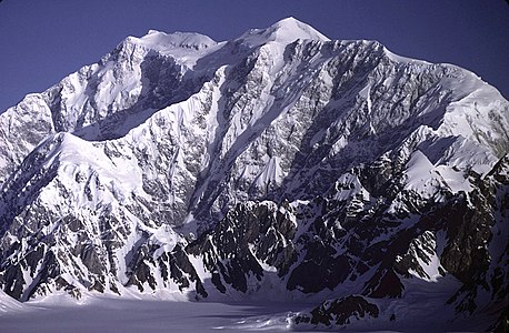 Mount Logan in Yukon is the highest summit of Canada.
 -
 Pico de Orizaba is the highest summit of México.
 -
 Popocatépetl is the second highest summit of México.
 -
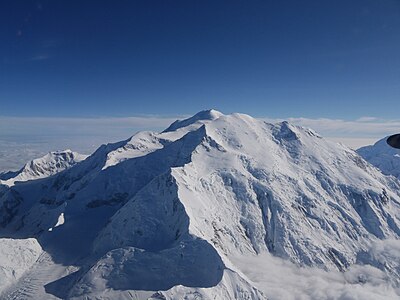 Mount Foraker is the second highest major summit of the Alaska Range.
 -
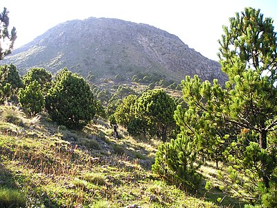 Volcán Tajumulco is the highest summit in Guatemala and all of Central America.
 -
 7Mount Hayes is the highest summit of the eastern Alaska Range.
 -
 Volcán Acatenango in Guatemala.
 -
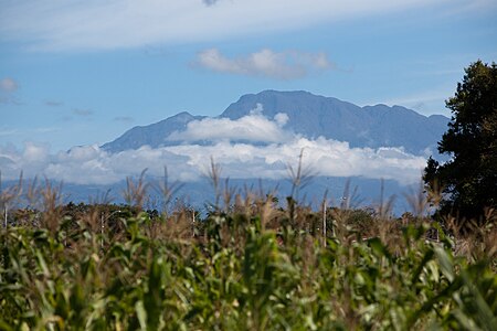
 Chirripó Grande is the highest summit of Costa Rica.
 -

-
 Volcán Barú is the highest summit of Panamá.
 -

-

-

-
 Mount Vsevidof is the highest summit of Umnak Island and the Fox Islands in the Aleutian Islands of Alaska.
 -
 Tanaga Volcano is the highest summit of Tanaga Island and the Andreanof Islands in the Aleutian Islands of Alaska.
 -

-

-


.jpg)


See also
- North America
- Geography of North America
- Geology of North America
- Lists of mountain peaks of North America
- List of mountain peaks of North America
- List of the highest major summits of North America
- List of the most prominent summits of North America
- List of the most isolated major summits of North America
- List of extreme summits of North America
- List of mountain peaks of Greenland
- List of mountain peaks of Canada
- List of mountain peaks of the Rocky Mountains
- List of mountain peaks of the United States
- List of mountain peaks of México
- List of mountain peaks of Central America
- List of mountain peaks of the Caribbean
- Category:Mountains of North America
- List of mountain peaks of North America
- Physical geography
References
- ^ This article defines greater North America as the portion of the continental landmass of the Americas extending westward and northward from the Isthmus of Panama plus the ocean islands surrounding that landmass. This article defines the ocean islands of greater North America to include the coastal islands of North America, the islands of the Caribbean Sea, the Lucayan Archipelago, the islands of Greenland (Kalaallit Nunaat), the islands of Canada, and the islands of Alaska. The Hawaiian Islands are not included because they are considered part of Oceania.
- ^ All elevations in the 48 states of the contiguous United States include an elevation adjustment from the National Geodetic Vertical Datum of 1929 (NGVD 29) to the North American Vertical Datum of 1988 (NAVD 88). For further information, please see this United States National Geodetic Survey note.
- ^ a b If the elevation or prominence of a summit is calculated as a range of values, the arithmetic mean is shown.
- ^ The topographic prominence of a summit is the topographic elevation difference between the summit and its highest or key col to a higher summit. The summit may be near its key col or quite far away. The key col for Denali in Alaska is the Isthmus of Rivas in Nicaragua, 7642 kilometers (4749 miles) away.
- ^ This article defines a significant summit as a summit with at least 100 meters (328.1 feet) of topographic prominence, and a major summit as a summit with at least 500 meters (1640 feet) of topographic prominence. All summits in this article have at least 500 meters of topographic prominence. An ultra-prominent summit is a summit with at least 1500 meters (4921 feet) of topographic prominence.
- ^ The topographic isolation of a summit is the great-circle distance to its nearest point of equal elevation.
- ^ "To the Top of the World". ReadandRun.com. 1998. Archived from the original on May 1, 2008. Retrieved May 6, 2008.
{{cite news}}: Unknown parameter|deadurl=ignored (|url-status=suggested) (help)
External links
 Definitions from Wiktionary
 Media from Commons
 News from Wikinews
 Quotations from Wikiquote
 Texts from Wikisource
 Textbooks from Wikibooks
 Resources from Wikiversity