
Budapest Metro
You can help expand this article with text translated from the corresponding article in Hungarian. (October 2016) Click [show] for important translation instructions.
|
This article needs additional citations for verification. (January 2016) |


,_K%C3%A1lvin_t%C3%A9r.jpg)

The Budapest Metro (Hungarian: Budapesti metró) is the rapid transit system in the Hungarian capital Budapest. It is the world's oldest electrified underground railway system, and the second oldest underground railway system after the originally steam-powered London Underground,[4] Budapest's iconic Line 1 was completed in 1896.[5][6]
The M1 line became an IEEE Milestone due to the radically new innovations in its era: "Among the railway's innovative elements were bidirectional tram cars; electric lighting in the subway stations and tram cars; and an overhead wire structure instead of a third-rail system for power."[7] Since 2002, the M1 line was listed as a UNESCO World Heritage Site.[8]
History

,_Andr%C3%A1ssy_%C3%BAt.png)

| UNESCO World Heritage Site | |
|---|---|
 Siemens-Halske, Budapest metro museum | |
| Official name | Andrássy Avenue and the Underground |
| Location | Budapest, Hungary |
| Part of | Budapest, including the Banks of the Danube, the Buda Castle Quarter and Andrássy Avenue |
| Criteria | Cultural: (ii), (iv) |
| Reference | 400bis-002 |
| Inscription | 1987 (11th Session) |
| Extensions | 2002 |
| Area | 57.85 ha (0.2234 sq mi) |
| Buffer zone | 239.61 ha (0.9251 sq mi) |
| Website | https://www.bkv.hu/ |
| Coordinates | 47°29′19″N 19°5′13″E / 47.48861°N 19.08694°E |
 Location of Budapest Metro in Hungary  Budapest Metro (Budapest) | |
The original Metro Line 1 ("Földalatti") ran for 5 km from Vörösmarty tér to Széchenyi fürdő[9] (from Hungarian föld "earth, ground", alatt "under"; so "the underground"). Line M1 was inaugurated on May 2, 1896, the year of the millennium (the thousandth anniversary of the arrival of the Magyars), by emperor Franz Joseph.[10] It was named "Franz Joseph Underground Electric Railway Company" ("Ferenc József Földalatti Villamos Vasút Rt.").
Works on Metro Line 2 started in the 1950s, although the first section did not open until 1970. It follows an east–west route, connecting the major Keleti (Eastern) and Déli (Southern) railway stations.[9]
Planning for Metro Line 3 began in 1963 and construction started in 1970 with help of Soviet specialists.[citation needed] The first section, consisting of six stations, opened in 1976. It was extended to the south in 1980 with five additional stations, and to the north in 1981, 1984, and 1990, with nine additional stations. With a length of approximately 16 kilometres (9.9 mi) and a total of 20 stations, it is the longest line in Budapest.[citation needed]
Construction of the fourth Metro line began in 2004.[11] The line opened after several delays and budget overruns in May 2014.[12]
Routes
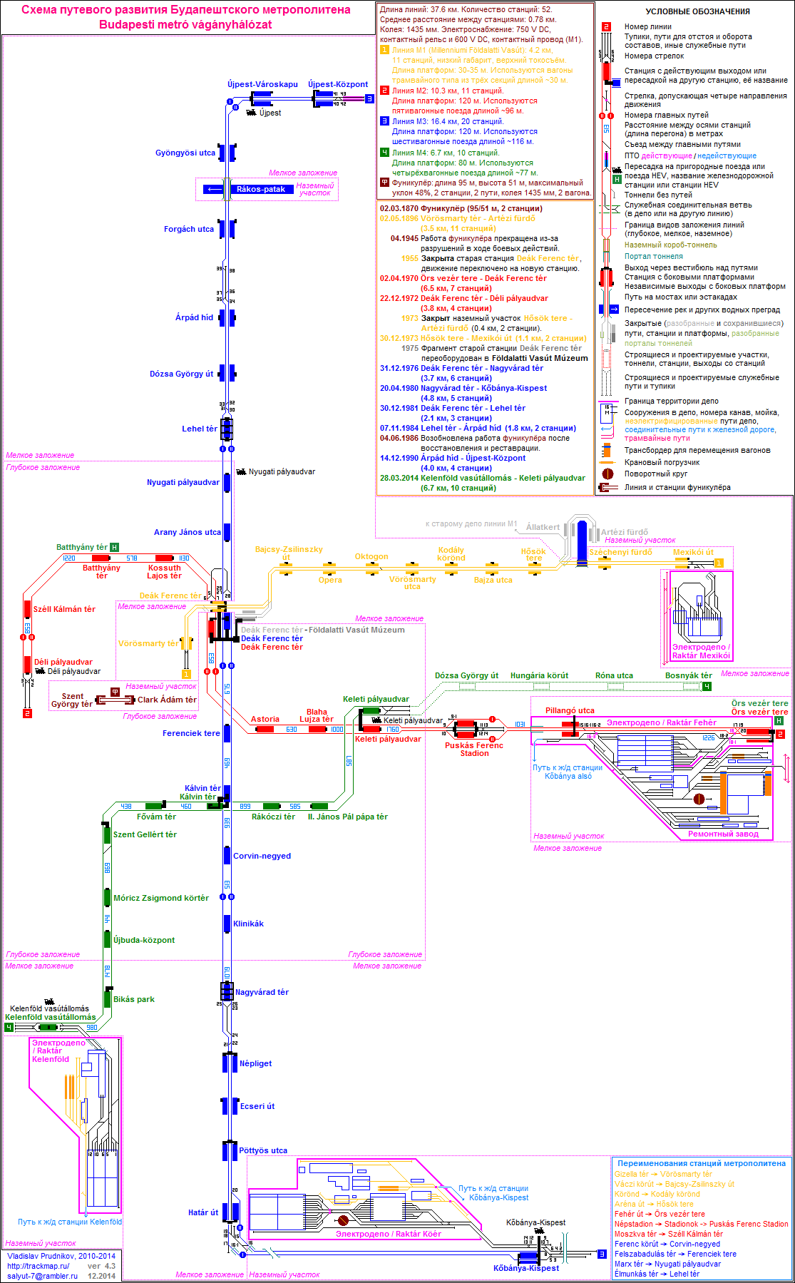
The metro consists of four lines (M1–M4), each denoted by a different colour. M1 (yellow) runs from Mexikói út south-west towards the river. The M2 (red) line travels east–west through the city, crossing the Danube. The M3 (blue) runs in a broadly north–south alignment, interchanging with the three other lines. The M4 (green) line commences at Keleti pályaudvar and travels south-west, crossing the river, to terminate at Kelenföld vasútállomás.[9]
| Line | Color | Name and Route |
Year of opening |
Latest extension |
Length (km) |
Number of stations |
|---|---|---|---|---|---|---|
| Yellow | Line M1 (Vörösmarty tér ↔ Mexikói út)[13] |
1896 | 1973 | 4.4 | 11 | |
| Red | Line M2 (Déli pályaudvar ↔ Örs vezér tere)[14] |
1970 | 1972 | 10.3 | 11 | |
| Blue | Line M3 (Újpest-Központ ↔ Kőbánya-Kispest)[15] |
1976 | 1990 | 17.3 | 20 | |
| Green | Line M4 (Keleti pályaudvar ↔ Kelenföld vasútállomás)[16] |
2014 | - | 7.3 | 10 | |
| Total: | 39.4 | 52 | ||||
Metro line M1

Line 1 runs northeast from the city centre on the Pest side under Andrássy út to the Városliget, or City Park. Like Metro 3, it does not serve Buda. Line 1, the oldest of the metro lines operating in Budapest, has been in constant operation since 1896. In the 1980s and 1990s, the line underwent major reconstruction. Of its 11 stations currently served, eight are original and three were added during the reconstruction. The original appearance of the old stations has been preserved, and each station feature displays of historical photographs and information. As part of the reconstructiona Millennium Underground Museum in the old station at Deák Ferenc tér connected to the concourse. There are plans for the future extension of the line in both directions.[17]
Metro line M2
Line 2 runs east–west from Déli pályaudvar in Buda's Krisztinaváros, through the city center, to Örs vezér tere in eastern Pest. It offers connections to Hungarian State Railways at Déli and Keleti pályaudvars, to metro lines M1 and M3 at Deák Ferenc tér, to M4 at Keleti pályaudvar, to suburban railway lines 8 and 9 at Örs vezér tere, and to suburban railway line 5 at Batthyány tér. Prior to the opening of M4, it was (for more than 45 years) the only metro line that served the Buda side of the city. Metro Line 2 underwent a major reconstruction in the second half of the 2000s, with all of the track replaced and stations revamped by 2010. The entire fleet of Metrovagonmash 81-717/81-714 cars operating on the line were replaced with Alstom Metropolis metro cars by 2012.[18] Planning of a direct connection of Metro Line 2 and the suburban railway lines with a shared new station at Örs vezér tere and the addition of a potential new underground station near Hungexpo Budapest Congress and Exhibition Center, offering another interchange point to mainline railways began in 2021.[19]
Metro line M3

Line 3 runs in a north–south direction (more exactly, from north-northeast to southeast) on the Pest side of the river and connects several populous residential areas with the Inner City.[20] It has a transfer station with Line 1 and Line 2 at Deák Ferenc tér, and an interchange with Line 4 at Kálvin tér. It is the longest line in the Budapest Metro, its daily ridership is estimated at 610,000.[21] An automatic train drive system was introduced in 1990.[22] A complete renovation of the line started in 2017. The planned upgrades include renewing the stations, rebuilding the track, safety equipment, ventilation and tunnel insulation. Design works are entirely funded by the European Union under the New Széchenyi Plan. The project also includes the renovation of the rolling stock and a possible extension of the metro line to Káposztásmegyer.[23] As of May 2022, 12 of the 20 stations have been inaugurated.[24]
Metro line M4

Line 4 runs southwest–northeast from Kelenföldi pályaudvar in Buda's Kelenföld neighborhood to Keleti Railway Station in Józsefváros. With a length of 7.4 kilometres (4.6 mi), it connects to Hungarian State Railways at its termini, to the metro's Line 3 at Kálvin tér, and to Line 2 at Keleti. Line 4 was completed in March 2014 and comprises ten stations.[25]
Future expansion
Metro line M5

The Purple Line 5 is a proposed north–south railway tunnel to connect the currently separated elements of the suburban rail network, namely the H5, H6 and H7 HÉV-lines, and optionally the Budapest-Esztergom and Budapest-Kunszentmiklós-Tass railway lines. Currently the project does not have mainstream political support, only included in long-term plans. The first phase (planned until 2030)[26] would be the extension and connection of the southern H6 and H7 lines to the Astoria metro station via the Kálvin tér, thus connecting these lines to the metro lines M2 M3 and M4. The second phase would create a connection to the metro line M1 as well at the Oktogon, the M3 at Lehel tér then cross the Danube to the Buda side to connect the H5 HÉV towards Szentendre.[citation needed]
General information
Tickets and transfer system
The usual BKK tickets and passes can be used on all lines. Single tickets can be re-used when changing metro lines.[27]
There are plans for an automated fare collection system.[28] A contract for a system was signed in 2014,[29] but terminated in 2018 without completion.[30]
In popular culture
The internationally acclaimed 2003 Hungarian thriller Kontroll is set and was filmed in the metro system.
A scene in John Huston's 1981 film Escape to Victory features the historic Metro Line 1 as the Paris Métro in the 1940s.
A long fight sequence in the 2003 action film Underworld was filmed in the Budapest Metro.
Nyugati pályaudvar metro station also appears in the 2021 Marvel Cinematic Universe film Black Widow.
Network map

See also
Notes
References
- ^ Mátyás Jangel (September 2010). "Közszolgáltatási szerződés, utasjogok, a szolgáltatástervezés és ellenőrzés folyamata a kötöttpályás helyi- és elővárosi közforgalmú közlekedésben" [Public service contract, passenger rights, service planning and monitoring process of local and suburban public transport rail] (in Hungarian). BKV Zrt. Közlekedési Igazgatóság [Directorate of Public Office. Transport]. pp. 10 (and 3). Archived from the original (pdf) on 2015-01-28. Retrieved 2015-04-19. Metro usage per day – Line 1: 120,000; Line 2: 405,000; Line 3: 630,000. (Line 4 began operations in 2014, with a 110,000 ridership estimated by Centre for Budapest Transport (BKK) based on the latest year.)
- ^ "Urban passenger traffic in Hungary and Budapest by mode of transport". Hungarian Central Statistical Office. 2021-08-18. Retrieved 2021-09-14.
- ^ Siemens.com Budapest Line 4
- ^ Jennifer Walker (19 December 2018). "Budapest M1: Inside continental Europe's oldest metro network". CNN. Retrieved 29 July 2019.
- ^ "World Heritage Committee Inscribes 9 New Sites on the World Heritage List". UNESCO World Heritage Centre. Archived from the original on November 28, 2009.
- ^ "Our thematic route with... - Sightseeing along the line of Millennium Underground Railway". BKV Zrt. Retrieved 2013-10-18.
- ^ Budapest's Electric Underground Railway Is Still Running After More Than 120 Years [1]
- ^ UNESCO World Heritage Centre. "UNESCO World Heritage Centre – World Heritage Committee Inscribes 9 New Sites on the World Heritage List". whc.unesco.org. Archived from the original on 28 November 2009. Retrieved 10 April 2013.
- ^ a b c Robert Schwandl. "Budapest". UrbanRail.net. Retrieved 1 August 2019.
- ^ "First underground railway of Europe was opened in Budapest – Photo gallery". 7 May 2017.
- ^ "Budapest's new bus service framework".
- ^ "Budapest opens controversial Metro Line 4".
- ^ Robert Schwandl. "Line M1 Vörösmarty tér - Mexikói út". UrbanRail. Retrieved 27 March 2019.
- ^ Robert Schwandl. "Line M2 Déli pályaudvar - Örs vezér tere". UrbanRail. Retrieved 27 March 2019.
- ^ Robert Schwandl. "Line 3 Újpest-Központ - Kõbánya-Kispest". UrbanRail. Retrieved 29 July 2019.
- ^ Robert Schwandl. "Line M4 Keleti pályaudvar- Kelenföld vasútállomás". UrbanRail. Retrieved 27 March 2019.
- ^ "M1-es metró korszerűsítése és meghosszabbítása - Budapesti Közlekedési Központ". Budapesti Közlekedési Központ (in Hungarian). Retrieved 2017-10-01.
- ^ "Alstom hands over first Budapest Metropolis train". 12 July 2012.
- ^ https://innorail2021.hu/wp-content/uploads/2021/12/Janos-KROL_Interconnecting-M2-metro-and-H8-H9-HEV-suburban-lines.pdf [bare URL PDF]
- ^ Budapest City Atlas, Dimap-Szarvas, Budapest, 2011, ISBN 978-963-03-9124-5
- ^ Metro4 - How does it work?
- ^ "Budapest metro Line 3 reconstruction enters final phase". 9 November 2020.
- ^ "Megjelent az M3-as metróvonal rekonstrukciójának tervezésére kiírt pályázat". Budapesti Közlekedési Központ. 25 July 2013. Retrieved 1 June 2021.
- ^ "Three reconstructed stations opened on the central section of metro line M3".
- ^ "Automated metro Line M4 opens in Budapest". Railway Gazette. 28 March 2014. Retrieved 9 April 2015.
- ^ Balázs Mór plan, long term service development plans of the BKK
- ^ "Types and prices".
- ^ (in Hungarian) https://tldr.444.hu/2018/03/12/mar-milliardokert-uzemeltetjuk-budapesten-az-elektronikus-jegyrendszert-holott-meg-el-sem-keszult
- ^ "Budapest signed the Contract Agreement for the Automated Fare Collection system". BKK Zrt. 8 October 2014. Retrieved 24 October 2014.
- ^ (in Hungarian) https://azonnali.hu/cikk/20181129_elektronikus-jegyrendszer-felmondta-a-bkk-a-beszallitoi-szerzodest
External links
- Budapest Metro Map 2016–17 on Google earth with geolocation
- BKK Zrt. – official website
- Budapest Metro Track map
- Budapest at UrbanRail.net
- Budapest Metro Map
| Landmarks |
| ||||||||||||||||||||||||
|---|---|---|---|---|---|---|---|---|---|---|---|---|---|---|---|---|---|---|---|---|---|---|---|---|---|
| Districts |
| ||||||||||||||||||||||||
| Events and traditions | |||||||||||||||||||||||||
| Universities |
| ||||||||||||||||||||||||
| Economy | |||||||||||||||||||||||||
| Transport | |||||||||||||||||||||||||
 | ||
| |
| |
| |
Rapid transit in Europe | |
|---|---|
* Under construction. | |