Grainger County, Tennessee: Difference between revisions
m r2.7.1) (Robot: Adding hy:Գրեյնջեր շրջան (Թենեսի) |
→External links: added Grainger County TNGenWeb |
||
| Line 81: | Line 81: | ||
==External links== |
==External links== |
||
{{Commons category}} |
{{Commons category}} |
||
* [http://www.tngenweb.org/grainger Grainger County, TNGenWeb] - free genealogy resources for the county |
|||
*{{dmoz|Regional/North_America/United_States/Tennessee/Counties/Grainger/|Grainger County}} |
*{{dmoz|Regional/North_America/United_States/Tennessee/Counties/Grainger/|Grainger County}} |
||
Revision as of 03:35, 13 March 2012
Grainger County | |
|---|---|
 Grainger County Courthouse in Rutledge | |
 Location within the U.S. state of Tennessee | |
 Tennessee's location within the U.S. | |
| Coordinates: 36°17′N 83°31′W / 36.28°N 83.51°W | |
| Country | |
| State | |
| Founded | 1796 |
| Seat | Rutledge |
| Largest city | Bean Station |
| Area | |
| • Total | 302 sq mi (783 km2) |
| • Land | 280 sq mi (726 km2) |
| • Water | 22 sq mi (57 km2) 7.31% |
| Population (2010) | |
| • Total | 22,657 |
| • Density | 74/sq mi (28/km2) |
| Time zone | UTC−5 (Eastern) |
| • Summer (DST) | UTC−4 (EDT) |
Grainger County is a county located in the U.S. state of Tennessee renowned for its tomatoes. Together with Hamblen and Jefferson counties, it is part of the Morristown, Tennessee, Metropolitan Statistical Area which is, as of December 2005, considered a component of the Knoxville-Sevierville-La Follette, TN, Combined Statistical Area.[1] As of 2010, the population was 22,657. Its county seat is RutledgeTemplate:GR.
Pronunciation
Hear it spoken (Voice of Grainger County Mayor Mark Hipsher, 2010)
Geography
Grainger County is bounded on the northwest by the Clinch River (impounded by Norris Dam to form Norris Lake) and on the southeast by the Holston River (including Cherokee Lake). According to the U.S. Census Bureau, the county has a total area of 302 square miles (782.2 km2), of which 280 square miles (725.2 km2) is land and 22 square miles (57.0 km2) (7.31%) is water. Clinch Mountain is a major geographic feature that effectively separates the county into a southern section (including Rutledge) and a northern section (including Washburn).
Indian Cave
Indian Cave is a very historic cave located on the Holston River near the community of Blaine. A Cherokee Indian village was located just west of the main cave entrance in the 1700s. Remains of cane torches and other artifacts located in the cave indicate prehistoric use of the cave. The Donelson Party passed the Indian Cave Entrance on their way down the Holston River in 1779 while on their way to settle Nashville, Tennessee. ("Caves of Knoxville and the Great Smoky Mountains" by Larry E. Matthews, published by the National Speleological Society, 2008, ISBN 978-1-879961-30-2, Chapter 4: Indian Cave, pages 83-104)
Confederate General Robert Fredrick Hoke purchased the cave on July 21, 1869 and mined bat guano, a vaulable natural fertilizer. (Matthews, 2008)
The Indian Cave Park Association was formed on January 4, 1916 to develop the cave as a commercial attraction, but the cave did not officially open to the public until May 30, 1924. The cave is still open to the public. (Matthews, 2008)
Adjacent counties
- Hancock County and Hawkins County (northeast)
- Hamblen County (east)
- Jefferson County (south)
- Knox County (southwest)
- Union County (west)
- Claiborne County (northwest)
Demographics

As of the censusTemplate:GR of 2000, there were 20,659 people, 8,270 households, and 6,161 families residing in the county. The population density was 74 people per square mile (28/km²). There were 9,732 housing units at an average density of 35 per square mile (13/km²). The racial makeup of the county was 98.41% White, 0.32% Black or African American, 0.15% Native American, 0.09% Asian, 0.02% Pacific Islander, 0.40% from other races, and 0.61% from two or more races. 1.09% of the population were Hispanic or Latino of any race.
There were 8,270 households out of which 31.40% had children under the age of 18 living with them, 61.90% were married couples living together, 8.80% had a female householder with no husband present, and 25.50% were non-families. 22.50% of all households were made up of individuals and 9.10% had someone living alone who was 65 years of age or older. The average household size was 2.48 and the average family size was 2.89.
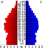
In the county, the population was spread out with 22.90% under the age of 18, 8.20% from 18 to 24, 30.50% from 25 to 44, 25.80% from 45 to 64, and 12.50% who were 65 years of age or older. The median age was 38 years. For every 100 females there were 99.00 males. For every 100 females age 18 and over, there were 96.50 males.
The median income for a household in the county was $27,997, and the median income for a family was $33,347. Males had a median income of $25,781 versus $19,410 for females. The per capita income for the county was $14,505. About 15.10% of families and 18.70% of the population were below the poverty line, including 22.40% of those under age 18 and 26.00% of those age 65 or over.
Populated places
- Bean Station
- Blaine
- Joppa (unincorporated)
- Liberty Hill (unincorporated)
- Powder Springs (unincorporated)
- Rutledge
- Tater Valley (unincorporated)
- Thorn Hill (unincorporated)
- Washburn (unincorporated)
See also
References
- ^ Based on 2000 census data
External links
- Grainger County, TNGenWeb - free genealogy resources for the county
- Grainger County at Curlie

