
Provinces of the Netherlands: Difference between revisions
| Line 184: | Line 184: | ||
| [[The Bottom]] |
| [[The Bottom]] |
||
| The Bottom |
| The Bottom |
||
| [[Jonathan Johnson]] |
| [[Jonathan Johnson (politician|Jonathan Johnson]] |
||
| style="text-align:right"|{{nts|13}} |
| style="text-align:right"|{{nts|13}} |
||
| style="text-align:right"|{{nts|2000}} |
| style="text-align:right"|{{nts|2000}} |
||
Revision as of 11:19, 5 December 2013
| Part of the Politics series |
![Azure, billetty Or a lion with a coronet Or armed and langued Gules holding in his dexter paw a sword Argent hilted Or and in the sinister paw seven arrows Argent pointed and bound together Or. [The seven arrows stand for the seven provinces of the Union of Utrecht.] The shield is crowned with the (Dutch) royal crown and supported by two lions Or armed and langued gules. They stand on a scroll Azure with the text (Or) "Je Maintiendrai" (French for "I will maintain".)](/wiki/File:State_coat_of_arms_of_the_Netherlands.svg) |
|---|
|
|
A Dutch province represents the administrative layer in between the national government and the local municipalities, having the responsibility for matters of subnational or regional importance. The government of each province consists of three major parts: the Provinciale Staten which is the provincial parliament elected every four years; the Gedeputeerde Staten, a college elected from among the members of the Provinciale Staten and charged with most executive tasks; and the Commissaris van de Koning, who is appointed by the Crown and presides over the Gedeputeerde Staten.
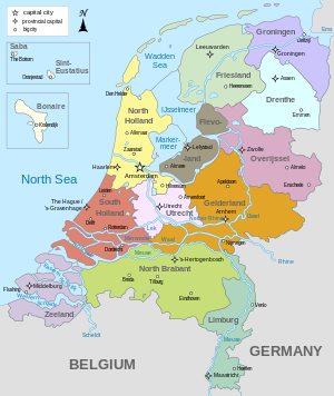
List of provinces
The modern Netherlands is divided into twelve provinces (provincies in Dutch) and three overseas public bodies (openbare lichamen) that are not part of any province. The twelve provinces are listed below.
| Flag | Arms | Province | Capital | Largest city | King's Commissioner | Area (km²) |
Population | Density (per km²) |
|---|---|---|---|---|---|---|---|---|
| Drenthe | Assen | Assen | Jacques Tichelaar | 2,652 | 489,918 | 182 | ||
| Coat of arms of Flevoland | Flevoland | Lelystad | Almere | Leen Verbeek | 1,426 | 394,758 | 250 | |
| Friesland (West Frisian: Fryslân) | Leeuwarden | Leeuwarden | John Jorritsma | 3,361 | 646,305 | 191 | ||
| Gelderland | Arnhem | Nijmegen | Clemens Cornielje | 4,995 | 1,999,135 | 394 | ||
| Groningen (Gronings: Grönnen; West Frisian: Grinslân) | Groningen | Groningen | Max van den Berg | 2,344 | 574,042 | 246 | ||
 |
Limburg | Maastricht | Maastricht | Theo Bovens (called governor in Limburg) | 2,167 | 1,131,938 | 527 | |
| North Brabant (Noord-Brabant) | 's-Hertogenbosch[A] | Eindhoven | Wim van de Donk | 4,938 | 2,415,946 | 487 | ||
 |
North Holland (Noord-Holland)[1] | Haarlem[B] | Amsterdam[C] | Johan Remkes | 2,660 | 2,724,300 | 1,020 | |
| Overijssel | Zwolle | Enschede | Ank Bijleveld | 3,337 | 1,113,529 | 331 | ||
| South Holland (Zuid-Holland) | The Hague[D] | Rotterdam | Jan Franssen | 2,860 | 3,528,324 | 1,207 | ||
| Utrecht | Utrecht | Utrecht | Roel Robbertsen | 1,356 | 1,180,039 | 855 | ||
| Zeeland | Middelburg | Middelburg | Han Polman | 1,792 | 380,186 | 211 |
- ^ Also, though not officially, abbreviated as Den Bosch.
- ^ Even though the country's capital Amsterdam lies in North Holland, Haarlem is the capital city of the province.
- ^ Amsterdam is the constitutional national capital of the Netherlands.[2]
- ^ Dutch: Den Haag, officially also: 's-Gravenhage. The Dutch parliament and the Dutch government have been situated in The Hague since 1588, along with the Supreme Court and the Council of State.[3]
Public bodies
The three public bodies of Bonaire, Sint Eustatius and Saba became parts of the Netherlands proper on October 10, 2010, but are not part of any province.[4]
| Flag | Arms | Special municipality | Capital | Largest city |
Lieutenant Governor | Area (km²)[5] |
Population[6] | Density (per km²) |
|---|---|---|---|---|---|---|---|---|
.svg) |
Bonaire (Papiamento: Boneiru) | Kralendijk | Kralendijk | Lydia Emerencia | 294 | 15,414 | 52 | |
 |
Sint Eustatius | Oranjestad | Oranjestad | Gerald Berkel | 21 | 3,300 | 157 | |
 |
Saba | The Bottom | The Bottom | Jonathan Johnson | 13 | 2,000 | 154 |
History

Nearly all Dutch provinces can trace their origin to a medieval county or duchy, as can the provinces of regions in Belgium. Their status changed when they came under a single ruler who centralised their administration, reducing their powers. There were 17 in total: from these unified Netherlands, seven northern provinces formed the Republic of the Seven United Provinces in the 17th century, namely Holland, Zeeland, Gelderland, Utrecht, Friesland, Overijssel and Groningen. The Republic's lands also included Drenthe (one of the 17, but without the autonomous status of the others), and parts of Brabant, Limburg and Flanders, which were considered to be "conquered lands" and were governed directly by the Staten-Generaal, the parliament, hence their name Generality Lands. They were called Staats-Brabant, Staats-Limburg and Staats-Vlaanderen, meaning "state-owned". Each of these "Netherlands" had a high degree of autonomy, cooperating with each other mainly on defense and foreign relations, but otherwise keeping to their own affairs.
On January 1, 1796, under the Batavian Republic, Drenthe and Staats-Brabant became the eighth and ninth provinces of the Netherlands. The latter, which had been known as Bataafs Brabant, Batavian Brabant, changed its name to Noord Brabant, North Brabant, in 1815 when it became part of the United Kingdom of the Netherlands, which also contained (then) South Brabant, a province now in Belgium. This new unified state featured the provinces in their modern form, as non-autonomous subdivisions of the national state, and again numbering 17, though they were not all the same as the 16th century ones. In 1839, following the separation of Belgium, the original single province of Limburg was divided between the two countries, each now having a province called Limburg. A year later, Holland, the largest and most populous of the Dutch provinces, was also split into two provinces, for a total of 11. The 12th member was to be Flevoland, a province consisting almost entirely of reclaimed land, established on January 1, 1986.
French Period
During the Batavian Republic, the Netherlands was from 1798 to 1801 completely reorganised into eight new departments, most named after rivers, inspired by the French revolutionary example, in an attempt to do away with the old semi-autonomous status of the provinces. They are listed below, with their capitals and the territory of the former provinces that they mostly incorporated:
| English name | Dutch name | Capital | Contained the territory of |
|---|---|---|---|
| Department of the Ems | Departement van de Eems | Leeuwarden | Northern Friesland, Groningen |
| Department of the Old IJssel | Departement van de Oude IJssel | Zwolle | Southern Friesland, Drenthe, Overijssel, Northern Gelderland |
| Department of the Rhine | Departement van de Rijn | Arnhem | Central Gelderland, eastern Utrecht |
| Department of the Amstel | Departement van de Amstel | Amsterdam | The area around Amsterdam |
| Department of Texel | Departement van Texel | Alkmaar | Northern Holland minus Amsterdam, northwestern Utrecht |
| Department of the Delft | Departement van de Delft | Delft | Southern Holland up to the Meuse, southwestern Utrecht |
| Department of the Dommel | Departement van de Dommel | 's-Hertogenbosch | The eastern part of Batavian Brabant, southern Gelderland |
| Department of the Scheldt and Meuse | Departement van de Schelde en Maas | Middelburg | Zeeland, Holland south of the Meuse and the western part of Batavian Brabant |
After only three years, following a coup d'etat, the borders of the former provinces were restored, though not their autonomous status. They were now also called "departments" and Drenthe was added to Overijssel. In 1806 the Kingdom of Holland replaced the republic to further French interests. It was during this administration that Holland was first split in two, with the department of Amstelland to the north and that of Maasland to the south. East Frisia, then as now in Germany, was added to the kingdom as a department in 1807 and Drenthe split off again making a total of 11 departments.

When the Netherlands finally did become fully part of France in 1810, the departments of the kingdom and their borders were largely maintained, with some joined together. They were however nearly all renamed, again mainly after rivers, though the names differed from their Batavian counterparts. Following are their names and the modern day province they corresponded for the most part to:
| English name | French name | Dutch name | Modern province(s) |
|---|---|---|---|
| Department of the Zuiderzee | Département du Zuyderzée | Departement van de Zuiderzee | North Holland & Utrecht |
| Department of the Mouths of the Meuse | Département des Bouches-de-la-Meuse | Departement van de Monden van de Maas | South Holland |
| Department of the Mouths of the Scheldt | Département des Bouches-de-l'Escaut | Departement van de Monden van de Schelde | Zeeland |
| Department of the Two Nethes | Département des Deux-Nèthes | Departement van de Twee Nethen | Western North Brabant & Antwerp |
| Department of the Mouths of the Rhine | Département des Bouches-du-Rhin | Departement van de Monden van de Rijn | Eastern North Brabant & southern Gelderland |
| Department of the Upper IJssel | Département de l'Yssel-Supérieur | Departement van de Boven IJssel | Northern Gelderland |
| Department of the Mouths of the IJssel | Département des Bouches-de-l'Yssel | Departement van de Monden van de IJssel | Overijssel |
| Department of Frisia | Département de la Frise | Departement Friesland | Friesland |
| Department of the Western Ems | Département de l'Ems-Occidental | Departement van de Wester Eems | Groningen & Drenthe |
| Department of the Eastern Ems | Département de l'Ems-Oriental | Departement van de Ooster Eems | (East-Frisia) |
With the defeat and withdrawal of the French in 1813, the old provinces and their names were re-established, Holland was reunited and East-Frisia went its separate way. The 17 provinces of the United Kingdom of the Netherlands were for a significant part based on the former French departments and their borders, in particular in what would later become Belgium.
See also
- ISO 3166-2:NL
- Table of administrative divisions by country
- Ranked list of Dutch provinces
- Flags of provinces of the Netherlands
- Coats of arms of provinces of the Netherlands
- Provincial politics in the Netherlands
References
- ^ http://www.noord-holland.nl/web/Over-de-provincie/Feiten-en-cijfers.htm
- ^ Daum, Andreas (2005). Berlin - Washington, 1800–2000 Capital Cities, Cultural Representation, and National Identities. Cambridge University Press. pp. 13, 38. ISBN 0521841178.
Amsterdam is the statuary capital of the Netherlands, while the Dutch government resides in De Hague. (sic) (p. 13) The Netherlands' seat of government is The Hague but its capital is bustling Amsterdam, the national cultural center. (p. 38)
- ^ "31.954, Wet openbare lichamen Bonaire, Sint Eustatius en Saba" (in Dutch). Eerste kamer der Staten-Generaal. Retrieved 2010-10-15.
De openbare lichamen vallen rechtstreeks onder het Rijk omdat zij geen deel uitmaken van een provincie. (The public bodies (...), because they are not part of a Province).
- ^ "Regionale Kerncijfers Nederland" (in Dutch). Statistics Netherlands. 2007. Retrieved 2007-10-13.
- ^ "Bevolking per regio naar leeftijd, geslacht en burgerlijke staat" (in Dutch). Statistics Netherlands. 2007. Retrieved 2007-10-13.
External links
- Population and area figures
- Basic data for each province, with links to official province sites
- "Provinces of the Netherlands". Statoids.
- Municipality data by province
 | ||