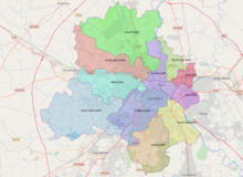
New Delhi district
New Delhi district | |
|---|---|
| Coordinates: 28°36′50″N 77°12′32″E / 28.6140°N 77.2089°E | |
| Country | |
| Union Territory | Delhi |
| Headquarters | New Delhi |
| Government | |
| • District collector | Santosh Kumar Rai, IAS[1] |
| Languages | |
| • Official | Hindi, English |
| Time zone | UTC+5:30 (IST) |
| Nearest city | New Delhi |
| Website | dmnewdelhi |

The New Delhi district is an administrative district of Delhi in India.[2] Its district headquarters is New Delhi. It is named after New Delhi, the capital of India, located within its borders, and is in its entirety a part of the Delhi megacity. The district was founded in 1997,[3][4] but its borders significantly changed during the redrawing of the Delhi districts in 2012.[5]
Geography
The New Delhi district spans over all three municipalities of the National Capital Territory (NCT) of Delhi,[6] namely New Delhi, the Delhi Cantonment and parts of the Municipal Corporation of Delhi area. It covers the centrally located Lutyens' Delhi and reaches all the way to the NCT's southwestern borders to Gurugram.[7] As the other 10 districts of the NCT, it is subdivided into three tehsils: Chanakyapuri, Delhi Cantonment and Vasant Vihar.[8]
History
| Year | Pop. | ±% p.a. |
|---|---|---|
| 1961 | 143,846 | — |
| 1971 | 164,702 | +1.36% |
| 1981 | 144,115 | −1.33% |
| 1991 | 168,669 | +1.59% |
| 2001 | 179,112 | +0.60% |
| 2011 | 142,004 | −2.29% |
| source:[9] | ||
The New Delhi district was founded in 1997, when the former single district of the NCT was split into 9 districts.[10] In its then borders, the district covered 35 km².[11]
When the borders of the districts of Delhi were redrawn in 2012,[12] the New Delhi district became significantly bigger, now spanning all the way to the border to the neighboring state of Haryana.[13]
References
- ^ "Who's Who | District New Delhi, Government of NCT of Delhi | India". Retrieved 28 October 2023.
- ^ New Delhi district, retrieved 2 January 2021
- ^ Poonam Sharma: Structure and Growth of Mega City: An Inter-industry Analysis. Concept Publishing, 2010, ISBN 978-8180696756, p. 56
- ^ Districts of Delhi, delhionline.com, retrieved 2 January 2022
- ^ Geeta Gupta: Delhi gets two more revenue districts: Southeast, Shahdara, Indian Express, 12 September 2012, retrieved 2 January 2022
- ^ Prabhash K. Dutta: Beyond MCD election 2017: How 5 municipal corporations manage Delhi, why everyone can't vote tomorrow, India Today, 22 April 2017, retrieved 2 January 2022
- ^ New Delhi district: Map of the district, retrieved 2 January 2022
- ^ New Delhi district: Map of the district, retrieved 2 January 2022
- ^ "Decadal Variation in Population Since 1901". Retrieved 8 February 2020.
- ^ Districts of Delhi, delhionline.com, retrieved 2 January 2022
- ^ Directorate of Census Operations, Delhi: Census of India 2011: N.C.T of Delhi. District Census Handbook of All the Nine Districts.
- ^ Geeta Gupta: Delhi gets two more revenue districts: Southeast, Shahdara, Indian Express, 12 September 2012, retrieved 2 January 2022
- ^ New Delhi district: Map of the district, retrieved 2 January 2022

