
West Bank

The West Bank (Arabic: الضفة الغربية aḍ-Ḍaffah l-Ġarbiyyah, Hebrew: הגדה המערבית, HaGadah HaMa'aravit, also Hebrew: יהודה ושומרון Yehuda ve-Shomron (Judea and Samaria)[1][2]) is a landlocked territory, located in Western Asia forming the bulk of the Palestinian Territories. The West Bank shares boundaries (demarcated by the Jordanian-Israeli armistice of 1949) to the west, north, and south with the state of Israel, and to the east, across the Jordan River, with the Kingdom of Jordan. The West Bank also contains a significant coastline along the western bank of the Dead Sea.[3]
The West Bank, including East Jerusalem, has a land area of 5,640 km2 and 220 km2 water, the northwest quarter of the Dead Sea.[3] It has an estimated population of 2,622,544 (June 2012). More than 80 percent, about 2,100,000,[3] are Palestinian Arabs, and approximately 500,000 are Jewish Israelis living in the West Bank,[3] including about 192,000 in East Jerusalem,[4] in Israeli settlements. The international community considers Israeli settlements in the West Bank, including East Jerusalem, illegal under international law, though Israel disputes this.[5][6][7][8]
From 1517 through 1917, the area now known as the West Bank was under Ottoman rule as part of the provinces of Syria. At the 1920 San Remo conference, the victorious Allied powers (France, UK, USA, etc.) allocated the area to the British Mandate of Palestine. Following the Second World War, the United Nations passed the United Nations General Assembly Resolution 181 (II) Future Government of Palestine, which aimed to establish two states within Mandate Palestine. The Resolution designated the territory described as "the hill country of Samaria and Judea" (including what is now known as the "West Bank") as part of the proposed Arab state, but following the 1948 Arab-Israeli War this area was captured by Transjordan (renamed Jordan in 1949). "West Bank" or "Cisjordan" became the name for the area west of the Jordan River, as "East Bank" or "Transjordan" designated the area east of the river. The interim boundary between Israel and Jordan's West Bank was defined in the 1949 Armistice Agreements. Jordan ruled over the West Bank from 1948 until 1967, annexing it in 1950. Jordan's claim was never formally recognized by the international community, with the exception of the United Kingdom.[9][10]
In June 1967, the West Bank and East Jerusalem were captured by Israel as a result of the Six-Day War. With the exception of East Jerusalem and the former Israeli-Jordanian no man's land, the West Bank was not annexed by Israel but has remained under Israeli military control and is referred to as Judea and Samaria Area by Israel. Although the 1974 Arab League summit resolution at Rabat designated the Palestinian Liberation Organization (PLO) as the “sole legitimate representative of the Palestinian people”, Jordan did not officially relinquish its claim to the area until 1988,[11] when it severed all administrative and legal ties with the West Bank and eventually stripped West Bank Palestinians of Jordanian citizenship.[12]
Since the 1993 Oslo Accords, the Palestinian Authority officially controls a geographically non-contiguous approx. 11% of the West Bank (known as Area A), subject to Israeli incursions. Area B (approx. 28%) is subject to Israeli military control and Palestinian civil control. Area C (approx. 61%) is under full Israeli control. Though 164 nations refer to the West Bank, including East Jerusalem, as “Occupied Palestinian Territory”,[13][14] the state of Israel insists that only territories captured in war from “an established and recognized sovereign” should be considered occupied territories.[15] Israel's occupation of this territory is not recognized by any state. After the 2007 split between Fatah and Hamas, the West Bank areas under Palestinian control are an exclusive part of the Palestinian Authority, while the Gaza Strip is ruled by Hamas.
Etymology
West Bank

The name West Bank in Palestine, a translation of the Arabic term ad-difa’a al-gharbiya, was coined by the Jordanians after the territory, conquered by Jordan's Arab Legion in 1948, was annexed to Transjordan, forming the new Kingdom of Jordan in 1949–50. This annexation by Jordan was recognized by only Britain and possibly Pakistan.
Most international bodies, the Arab League, and most Palestinians rejected the legality of the Jordanian annexation. The term was chosen to differentiate the "West bank of the River Jordan", the newly annexed territory, from the "East Bank" of this river, Transjordan. Before the end of World War I and the creation of the British Mandate of Palestine (that preceded the modern history of the Palestinian-Israeli conflict), the last state to control the land today referred to as the West Bank was the Ottoman Empire, Ottoman Syria. The Ottoman Empire administrative region that included the modern West Bank was referred to by the Ottomans as the Beirut Vilayet. The specific district that included the modern West Bank was known as the Sanjak of Nablus. The government of Israel, which has occupied the West Bank since 1967, refers to the area by the terminology "Judea and Samaria".
Cisjordan
The neo-Latin name Cisjordan or Cis-Jordan (literally "in front of the River Jordan" or "on this side of the [River] Jordan") is the usual name for the territory in the Romance languages and Hungarian. The analogous Transjordan (literally "behind of the River Jordan") has historically been used to designate the region now comprising the state of Jordan, which lies to the east, on the "other side" of the Jordan River. In English, the name Cisjordan is occasionally used to designate the entire region between the Jordan River and the Mediterranean, particularly in the historical context of the British Mandate and earlier times. The use of Cisjordan to refer to the smaller region discussed in this article, while common in scholarly fields including archaeology, is rare in general English usage. The name West Bank is standard usage for this geo-political entity in English and some of the other Germanic languages. For the low-lying area immediately west of the Jordan, the name Jordan Valley is used.[citation needed]
History
| History of Palestine |
|---|
-Temple_Mount-Dome_of_the_Rock_(SE_exposure).jpg) |
The region now known as the "West Bank" represents portion of the former British Mandate for Palestine (1920–47). It was designated as part of a proposed Arab state by the United Nations (UN) partition plan for Palestine in 1947. The plan recommended partition of the British Mandate into a Jewish State, an Arab State, and an internationally administered enclave of Jerusalem,[16] a more broad region of the modern-day West Bank was assigned to the Arab State.
Upon the departure of the British forces in May 1948 and the proclamation of the State of Israel, the armies of five Arab countries entered Palestine. In the ensuing Arab-Israeli War the West Bank was occupied by Jordanian and Iraqi forces. In the 1949 Armistice Agreements, the West Bank was declared part of Jordanian territory and defined the interim boundary between Israel and Jordan.
Jordan occupied the West Bank from 1948 until 1967. Formally annexing it on April 24, 1950. Jordan's claim was never recognized by the international community, with the exception of the United Kingdom and Pakistan.[9] Whether Pakistan officially recognized the annexation is not clear.[10][17]
The idea of an independent Palestinian state was not raised by the Arab populations there at the time. King Abdullah of Jordan was crowned King of Jerusalem and granted Palestinian Arabs in the West Bank and East Jerusalem Jordanian citizenship.[18]
During the 1950s, there was a significant influx of Palestinian refugees and violence together with Israeli reprisal raids across the "Green Line".[citation needed]
In May 1967 Egypt ordered out U.N. peacekeeping troops and re-militarized the Sinai peninsula, and commenced an economic blockade of Israel through the straits of Tiran at the same time. Fearing an Egyptian attack, the government of Levi Eshkol attempted to restrict any confrontation to Egypt alone. In particular it did whatever it could to avoid fighting Jordan in a two-front war. However, "carried along by a powerful current of Arab nationalism", on 30 May 1967 King Hussein flew to Egypt and signed a mutual defense treaty in which the two countries agreed to consider "any armed attack on either state or its forces as an attack on both".[19][20] On 5 June, the Israel Defense Forces launched a pre-emptive attack on Egypt[21] which began what came to be known as the Six Day War.
Jordan soon began shelling targets in west Jerusalem, Netanya, and the outskirts of Tel Aviv.[22] Despite this, Israel sent a message promising not to initiate any action against Jordan if it stayed out of the war. Hussein replied that it was too late, "the die was cast".[19] On the evening of 5 June the Israeli cabinet convened to decide what to do; Yigal Allon and Menahem Begin argued that this was an opportunity to take the Old City of Jerusalem, but Eshkol decided to defer any decision until Moshe Dayan and Yitzhak Rabin could be consulted.[23] Uzi Narkis made a number of proposals for military action, including the capture of Latrun, but the cabinet turned him down. The Israeli military only commenced action after Government House was captured, which was seen as a threat to the security of Jerusalem.[24] On 6 June Dayan encircled the city, but, fearing damage to holy places and having to fight in built-up areas, he ordered his troops not to go in. However, upon hearing that the U.N. was about to declare a ceasefire, he changed his mind, and without cabinet clearance, decided to take the city.[23] After fierce fighting with Jordanian troops in and around the Jerusalem area, Israel captured the Old City on 7 June.
No specific decision had been made to capture any other territories controlled by Jordan. After the Old City was captured, Dayan told his troops to dig in to hold it. When an armored brigade commander entered the West Bank on his own initiative, and stated that he could see Jericho, Dayan ordered him back. However, when intelligence reports indicated that Hussein had withdrawn his forces across the Jordan river, Dayan ordered his troops to capture the West Bank.[24] Over the next two days, the IDF swiftly captured the rest of the West Bank and blew up the Abdullah and Hussein Bridges over the Jordan, thereby severing the West Bank from the East.[25] According to Narkis:
First, the Israeli government had no intention of capturing the West Bank. On the contrary, it was opposed to it. Second, there was not any provocation on the part of the IDF. Third, the rein was only loosened when a real threat to Jerusalem's security emerged. The end result was something that no one had planned.[26]
The Arab League's Khartoum conference in September declared continuing belligerency, and stated the league's principles of "no peace with Israel, no recognition of Israel, no negotiations with it".[27] In November 1967, UN Security Council Resolution 242 was unanimously adopted, calling for "the establishment of a just and lasting peace in the Middle East" to be achieved by "the application of both the following principles:" "Withdrawal of Israeli armed forces from territories occupied in the recent conflict" (see semantic dispute) and: "Termination of all claims or states of belligerency" and respect for the right of every state in the area to live in peace within secure and recognised boundaries. Egypt, Jordan, Israel and Lebanon entered into consultations with the UN Special representative over the implementation of 242.[28] The text did not refer to the PLO or to any Palestinian representative because none was recognized at that time.
Until 1974, Jordan demanded the restoration of its control over the West Bank.[29] In 1988, Jordan's King Hussein announced "full legal and administrative disengagement from the West Bank."[30] On July 28, 1988, King Hussein announced the cessation of a $1.3 billion development program for the West Bank. Over the next few days, he formally dissolved Parliament, ending West Bank representation in the legislature, and severed all administrative and legal ties with West Bank.[31]
As a result of the Israeli–Palestinian peace process agreement in 1995, the Palestine Authority has been given territorial administration over the West Bank.
Non-Member Observer State Status
By September 2012, with their application for full membership stalled due to the inability of Security Council members to 'make a unanimous recommendation', the Palestine Authority had decided to pursue an upgrade in status from "observer entity" to "non-member observer state". On November 27 it was announced that the appeal had been officially made, and would be put to a vote in the General Assembly on November 29, where their status upgrade was expected to be supported by a majority of states. In addition to granting Palestine "non-member observer state status", the draft resolution "expresses the hope that the Security Council will consider favourably the application submitted on 23 September 2011 by the State of Palestine for admission to full membership in the United Nations, endorses the two state solution based on the pre-1967 borders, and stresses the need for an immediate resumption of negotiations between the two parties."
On Thursday, November 29, 2012, In a 138-9 vote (with 41 abstaining) General Assembly resolution 67/19 passed, upgrading Palestine to "non-member observer state" status in the United Nations.[32][33] The new status equates Palestine's with that of the Holy See.The change in status was described by The Independent as "de facto recognition of the sovereign state of Palestine".[34]
The vote was a historic benchmark for the sovereign State of Palestine and its citizens, whilst it was a diplomatic setback for Israel and the United States. Status as an observer state in the UN will allow the State of Palestine to join treaties and specialised UN agencies, such as the International Civil Aviation Organisation,[35] the Law of the Seas Treaty and the International Criminal Court. It shall permit Palestine to claim legal rights over its territorial waters and air space as a sovereign state recognised by the UN.
The UN has permitted Palestine to title its representative office to the UN as 'The Permanent Observer Mission of the State of Palestine to the United Nations',[36] and Palestine has started to re-title its name accordingly on postal stamps, official documents and passports,[33][37] whilst it has instructed its diplomats to officially represent 'The State of Palestine', as opposed to the 'Palestine National Authority'.[33] Additionally, on 17 December 2012, UN Chief of Protocol Yeocheol Yoon decided that "the designation of 'State of Palestine' shall be used by the Secretariat in all official United Nations documents",[38] thus recognising the PLO-proclaimed State of Palestine as being sovereign over the territories of Palestine and its citizens under international law.
As of February 2013, 131 (67.9%) of the 193 member states of the United Nations have recognised the State of Palestine as sovereign over both West Bank and the Gaza Strip. Many of the countries that do not recognise the State of Palestine nevertheless recognise the PLO as the 'representative of the Palestinian people'
Geography


The West Bank has an area of 5,628 square kilometres (2,173 sq mi), which comprises 21,2% of former Mandatory Palestine (excluding Jordan)[39] and has generally rugged mountainous terrain. The total length of the land boundaries of the region are 404 km.[40] The terrain is mostly rugged dissected upland, some vegetation in west, but somewhat barren in the east. The elevation span between the shoreline of the Dead Sea at -408 m to the highest point at Mount Nabi Yunis, at 1,030 m (3,379 ft) above sea level.[41] The area of West Bank is landlocked; highlands are main recharge area for Israel's coastal aquifers.[40]
There are few natural resources in the area except the highly arable land, which comprises 27% of the land area of the region. It is mostly used as permanent pastures (32% of arable land) and seasonal agricultural uses (40%).[40] Forests and woodland comprise just 1%, with no permanent crops.[40]
Climate
The climate in the West Bank is mostly Mediterranean, slightly cooler at elevated areas compared with the shoreline, west to the area. In the east, the West Bank includes the Judean Desert and the shoreline of the Dead Sea - both with dry and hot climate.
Political Geography
Palestinian administration

The 1993 Oslo Accords declared the final status of the West Bank to be subject to a forthcoming settlement between Israel and the Palestinian leadership. Following these interim accords, Israel withdrew its military rule from some parts of the West Bank, which was divided into three administrative divisions of the Oslo Accords:
| Area | Security | Civil Admin | % of WB land |
% of WB Palestinians |
|---|---|---|---|---|
| A | Palestinian | Palestinian | 18% | 55% |
| B | Israeli | Palestinian | 21% | 41% |
| C | Israeli | Israeli | 61% | 4%[42] |
Area A, 2.7%, full civil control of the Palestinian Authority, comprises Palestinian towns, and some rural areas away from Israeli settlements in the north (between Jenin, Nablus, Tubas, and Tulkarm), the south (around Hebron), and one in the center south of Salfit.[43] Area B, 25.2%, adds other populated rural areas, many closer to the center of the West Bank. Area C contains all the Israeli settlements, roads used to access the settlements, buffer zones (near settlements, roads, strategic areas, and Israel), and almost all of the Jordan Valley and the Judean Desert.
Areas A and B are themselves divided among 227 separate areas (199 of which are smaller than 2 square kilometers (1 sq mi)) that are separated from one another by Israeli-controlled Area C. [44] Areas A, B, and C cross the 11 Governorates used as administrative divisions by the Palestinian National Authority, Israel, and the IDF and named after major cities. The mainly open areas of Area C were to be handed over to the Palestinians by 1999 under the Oslo Accords. This was never done.[45]
According to B'tselem, while the vast majority of the Palestinian population lives in areas A and B, the vacant land available for construction in dozens of villages and towns across the West Bank is situated on the margins of the communities and defined as area C.[46]
An assessment by the UN Office for the Coordination of Humanitarian Affairs in 2007 found that approximately 40% of the West Bank was taken up by Israeli infrastructure. The infrastructure, consisting of settlements, the barrier, military bases and closed military areas, Israeli declared nature reserves and the roads that accompany them is off-limits or tightly controlled to Palestinians.[47]
In June 2011, the Independent Commission for Human Rights published a report that found that Palestinians in the West Bank and the Gaza Strip were subjected in 2010 to an “almost systematic campaign” of human rights abuse by the Palestinian Authority and Hamas, as well as by Israeli authorities, with the security forces of the PA and Hamas being responsible for torture, arrests and arbitrary detentions.[48]
Areas annexed by Israel

Through the Jerusalem Law, Israel extended its administrative control over East Jerusalem. This has often been interpreted as tantamount to an official annexation, though Ian Lustick, in reviewing the legal status of Israeli measures, has argued that no such annexation ever took place. The Palestinian residents have legal permanent residency status.[49][50] Rejecting the Jerusalem Law, the UN Security Council passed UN Security Council Resolution 478, declaring that the law was "null and void". Although permanent residents are permitted, if they wish, to receive Israeli citizenship if they meet certain conditions including swearing allegiance to the State and renouncing any other citizenship, most Palestinians did not apply for Israeli citizenship for political reasons.[51] There are various possible reasons as to why the West Bank had not been annexed[52] to Israel after its capture in 1967. The government of Israel has not formally confirmed an official reason; however, historians and analysts have established a variety of such, most of them demographic. Among those most commonly cited have been:
- Reluctance to award its citizenship to an overwhelming number of a potentially hostile population whose allies were sworn to the destruction of Israel.[53][54]
- To ultimately exchange land for peace with neighbouring states[53][54]
- Fear that the population of ethnic Arabs, including Israeli citizens of Palestinian ethnicity, would outnumber the Jewish Israelis west of the Jordan River.[52][53]
- The disputed legality of annexation under the Fourth Geneva Convention[55]
The importance of demographic concerns to some significant figures in Israel's leadership was illustrated when Avraham Burg, a former Knesset Speaker and former chair of the Jewish Agency for Israel, wrote in The Guardian in September 2003,
- "Between the Jordan and the Mediterranean there is no longer a clear Jewish majority. And so, fellow citizens, it is not possible to keep the whole thing without paying a price. We cannot keep a Palestinian majority under an Israeli boot and at the same time think ourselves the only democracy in the Middle East. There cannot be democracy without equal rights for all who live here, Arab as well as Jew. We cannot keep the territories and preserve a Jewish majority in the world's only Jewish state – not by means that are humane and moral and Jewish."[56]
Israeli settlements

As of December 2010, 327,750 Israelis live in the 121 settlements in the West Bank officially recognised by the Israeli government, 192,000 Israelis live in settlements in East Jerusalem.[4] There are approximately 100 further settlement outposts which are not officially recognized by the Israeli government and are illegal under Israeli law, but have been provided with infrastructure, water, sewage, and other services by the authorities.[57][58]
The international consensus (including the United Nations) is that all Israeli settlements on the West Bank beyond the Green Line border are illegal under international law.[59][60][61][62] The European Union[63] and the Arab League[citation needed] consider the settlements to be illegal. The majority of legal scholars also hold the settlements to violate international law,[6] however individuals including Julius Stone,[64][65] and Eugene Rostow[66] have argued that they are legal under international law, on a number of different grounds.[67] Immediately after the 1967 war Theodor Meron, legal counsel of Israel's Foreign Ministry advised Israeli ministers in a "top secret" memo that any policy of building settlements across occupied territories violated international law and would "contravene the explicit provisions of the Fourth Geneva Convention".[68][69][70]
The UN Security Council has issued several non-binding resolutions addressing the issue of the settlements. Typical of these is UN Security Council resolution 446 which states [the] practices of Israel in establishing settlements in the Palestinian and other Arab territories occupied since 1967 have no legal validity, and it calls on Israel as the occupying Power, to abide scrupulously by the 1949 Fourth Geneva Convention.[71]
The Conference of High Contracting Parties to the Fourth Geneva Convention held in Geneva on 5 December 2001 called upon "the Occupying Power to fully and effectively respect the Fourth Geneva Convention in the Occupied Palestinian Territory, including East Jerusalem, and to refrain from perpetrating any violation of the Convention." The High Contracting Parties reaffirmed "the illegality of the settlements in the said territories and of the extension thereof."[72]
On 30 December 2007, Israeli Prime Minister Ehud Olmert issued an order requiring approval by both the Israeli Prime Minister and Israeli Defense Minister of all settlement activities (including planning) in the West Bank.[73]
Palestinian outposts

The Haaretz published on December 2005 about demolition of Palestinian outposts in Bil'in,[74] the demolitions sparked a political debate as according to PeaceNow it was a double standard ("After what happened today in Bil'in, there is no reason that the state should defend its decision to continue the construction" credited to Michael Sfard).
In January 2012, the European Union approved the "Area C and Palestinian state building" report. The report said Palestinian presence in Area C has been continuously undermined by Israel and that state building efforts in Area C of the Palestinian Authority (PA) and the EU were of "utmost importance in order to support the creation of a contiguous and viable Palestinian state". The EU will support various projects to "support the Palestinian people and help maintain their presence".[75][76]
In May 2012, a petition[77] was filed to the Israeli Supreme Court about the legality of more 15[77] Palestinian outposts and Palestinian building in "Area C". The cases were filed by the non-profit Regavim: National Land Protection Trust.[78][79]
The petition was one of 30 different petitions with the common ground of illegal land takeover and illegal construction and use of natural resources. some of the petitions (27) had been set for trials[80] and the majority received a verdict.
Ynet News stated on 11 Jan 2013 that a group of 200 Palestinians with unknown number of foreign activists created an outpost named Bab al-Shams ("Gate of the Sun"), contains 50 tents[81]
Ynet News stated on the 18 Jan 2013 that Palestinian activists built an outpost on a disputed area in Beit Iksa, where Israel plans to construct part of the separation fence in the Jerusalem vicinity while the Palestinians claim that the area belongs to the residents of Beit Iksa. named Bab al-Krama[82]
West Bank barrier


The Israeli West Bank barrier is a physical barrier ordered for construction by the Israeli Government, consisting of a network of fences with vehicle-barrier trenches surrounded by an on average 60 meters (197 ft) wide exclusion area (90%) and up to 8 meters (26 ft) high concrete walls (10%) (although in most areas the wall is not nearly that high).[83] It is located mainly within the West Bank, partly along the 1949 Armistice line, or "Green Line" between the West Bank and Israel. As of April 2006 the length of the barrier as approved by the Israeli government is 703 kilometers (437 mi) long.[needs update] Approximately 58.4% has been constructed, 8.96% is under construction, and construction has not yet begun on 33% of the barrier.[84] The space between the barrier and the green line is a closed military zone known as the Seam Zone, cutting off 8.5% of the West Bank and encompassing dozens of villages and tens of thousands of Palestinians.[85][86][87]
The barrier generally runs along or near the 1949 Jordanian-Israeli armistice/Green Line, but diverges in many places to include on the Israeli side several of the highly populated areas of Jewish settlements in the West Bank such as East Jerusalem, Ariel, Gush Etzion, Immanuel, Karnei Shomron, Givat Ze'ev, Oranit, and Maale Adumim.
Supporters of the barrier claim it is necessary for protecting Israeli civilians from Palestinian attacks, which increased significantly during the Al-Aqsa Intifada;[88][89] it has helped reduce incidents of terrorism by 90% from 2002 to 2005; over a 96% reduction in terror attacks in the six years ending in 2007,[90] though Israel's State Comptroller has acknowledged that most of the suicide bombers crossed into Israel through existing checkpoints.[91] Its supporters claim that the onus is now on the Palestinian Authority to fight terrorism.[92]
Opponents claim the barrier is an illegal attempt to annex Palestinian land under the guise of security,[93] violates international law,[94] has the intent or effect to pre-empt final status negotiations,[95] and severely restricts Palestinians who live nearby, particularly their ability to travel freely within the West Bank and to access work in Israel, thereby undermining their economy. According to a 2007 World Bank report, the Israeli occupation of the West Bank has destroyed the Palestinian economy, in violation of the 2005 Agreement on Movement and Access. All major roads (with a total length of 700 km) are basically off-limits to Palestinians, making it impossible to do normal business. Economic recovery would reduce Palestinian dependence on international aid by one billion dollars per year.[96]
Demographics

In December 2007, an official Census conducted by the Palestinian Authority found that the Palestinian Arab population of the West Bank (including East Jerusalem) was 2,345,000.[97][98] However, the World Bank and American-Israeli Demographic Research Group identified a 32% discrepancy between first-grade enrollment statistics documented by the Palestinian Ministry of Education and Palestinian Central Bureau of Statistics (PCBS)’ 2007 projections,[99] with questions also raised about the PCBS’ growth assumptions for the period 1997–2003.[100] Several media outlets[citation needed] have suggested that PCBS data inflate the 2007 census figures by 30%, contradicting both the Palestinian Ministry of Education's enrollment data and actual emigration growth documented by Israeli Border Police, which in 2006 observed 25,000 Palestinian Arabs emigrating from Palestinian Authority-controlled territories.[101] These data sets suggest that the Palestinian Arab population of the West Bank in 2007 was approximately 1.5 million.
There are 350,143 Israeli settlers living in the West Bank,[102] as well as around 210,000 living in Israeli-annexed East Jerusalem. There are also small ethnic groups, such as the Samaritans living in and around Nablus, numbering in the hundreds.
As of October 2007, around 23,000 Palestinians in the West Bank work in Israel every day with another 9,200 working in Israeli settlements. In addition, around 10,000 Palestinian traders from the West Bank are allowed to travel every day into Israel.[103]
In 2008, approximately 30% of Palestinians or 754,263 persons living in the West Bank were refugees or descendants of refugees from villages and towns located in what became Israel during the 1948 Arab-Israeli War according to UNRWA statistics.[104][105][106] A 2011 EU report noted that between 200,000 and 320,000 Palestinians used to live in the Jordan Valley, most of which is in Area C, in 1967, but demolition of Palestinian homes and prevention of new buildings has seen the number drop to 56,000.[107] In a similar period, the Jewish population in Area C has grown from 1,200 to 310,000.[107]


Major population centers
| Center | Population |
|---|---|
| Al-Bireh | 38,202[108] |
| Betar Illit | 37,600[109] |
| Ariel | 17,700[109] |
| Bethlehem | 25,266[108] |
| Hebron (al-Khalil) | 163,146[108] |
| Jericho | 18,346[108] |
| Jenin | 90,004[108] |
| Ma'ale Adummim | 33,259[109] |
| Modi'in Illit | 48,600[109] |
| Nablus | 136,132[108] |
| Qalqilyah | 41,739[108] |
| Ramallah | 27,460[108] |
| Tulkarm | 51,300[108] |
| Yattah | 48,672[108] |
The most densely populated part of the region is a mountainous spine, running north-south, where the cities of Jerusalem, Nablus, Ramallah, al-Bireh, Jenin, Bethlehem, Hebron and Yattah are located as well as the Israeli settlements of Ariel, Ma'ale Adumim and Betar Illit. Ramallah, although relatively mid in population compared to other major cities as Hebron, Nablus and Jenin, serves as an economic and political center for the Palestinians. Near Ramallah the new city of Rawabi is under construction.[110][111] Jenin in the extreme north and is the capital of north of the West Bank and is on the southern edge of the Jezreel Valley. Modi'in Illit, Qalqilyah and Tulkarm are in the low foothills adjacent to the Israeli Coastal Plain, and Jericho and Tubas are situated in the Jordan Valley, north of the Dead Sea.

Religion

The population of the West Bank is 75 percent Muslim while 17 percent is Jewish. The remaining 8 percent are Christians and others.[3]
Administrative divisions
Palestinian Governorates

After the signing of the Oslo Accords, the West Bank was divided into 11 governorates under the jurisdiction of the Palestinian National Authority. Since 2007 there are two governments claiming to be the legitimate government of the Palestinian National Authority, one based in the West Bank and one based in the Gaza Strip.
| Governorate[112] | Population[112] | Area (km2)[112] |
|---|---|---|
| Jenin Governorate | 556,212 | 583 |
| Tubas Governorate | 65,771 | 372 |
| Tulkarm Governorate | 175,213 | 239 |
| Nablus Governorate | 386,380 | 592 |
| Qalqilya Governorate | 120,753 | 164 |
| Salfit Governorate | 55,464 | 191 |
| Ramallah and Al-Bireh Governorate | 260,018 | 844 |
| Jericho Governorate | 48,724 | 608 |
| Jerusalem Governorate (including Israeli annexed East Jerusalem) |
462,521 | 344 |
| Bethlehem Governorate | 257,515 | 644 |
| Hebron Governorate | 751,129 | 1,060 |
| Total | 3,609,700 | 5,671 |
Israeli administrative districts
The West Bank is further divided into 8 administrative regions: Menashe (Jenin area), HaBik'a (Jordan Valley), Shomron (Shechem area, known in Arabic as Nablus), Efrayim (Tulkarm area), Binyamin (Ramallah/al-Bireh area), Maccabim (Maccabim area), Etzion (Bethlehem area) and Yehuda (Hebron area).
Transportation and communication
Roads

The West Bank has 5,147 km (3,198 mi) of roads, all of which are paved.[3]
In response to shootings by Palestinians, some highways, especially those leading to Israeli settlements, were completely inaccessible to cars with Palestinian license plates, while many other roads were restricted only to public transportation and to Palestinians who have special permits from Israeli authorities.[113][114][115] Due to numerous shooting assaults targeting Israeli vehicles, the IDF bars Israelis from using most of the original roads in the West Bank.[citation needed]
At certain times, Israel maintained more than 600 checkpoints or roadblocks in the region.[116] As such, movement restrictions were also placed on main roads traditionally used by Palestinians to travel between cities, and such restrictions are still blamed for poverty and economic depression in the West Bank.[117] Since the beginning of 2005, there has been some amelioration of these restrictions. According to reports, "Israel has made efforts to improve transport contiguity for Palestinians travelling in the West Bank. It has done this by constructing underpasses and bridges (28 of which have been constructed and 16 of which are planned) that link Palestinian areas separated from each other by Israeli settlements and bypass roads"[118] and by removal of checkpoints and physical obstacles, or by not reacting to Palestinian removal or natural erosion of other obstacles. "The impact (of these actions) is most felt by the easing of movement between villages and between villages and the urban centres."[118]

However, some obstacles encircling major Palestinian urban hubs, particularly Nablus and Hebron, have remained. In addition, the IDF prohibits Israeli citizens from entering Palestinian-controlled land (Area A).
As of August 2007[update], a divided highway is currently under construction that will pass through the West Bank. The highway has a concrete wall dividing the two sides, one designated for Israeli vehicles, the other for Palestinian. The wall is designed to allow Palestinians to pass north-south through Israeli-held land and facilitate the building of additional Jewish settlements in the Jerusalem neighborhood.[119]
As of February 2012[update], a plan for 475-kilometer rail network, establishing 11 new rail lines in West Bank, was confirmed by Israeli Transportation Ministry. The West Bank network would include one line running through Jenin, Nablus, Ramallah, Jerusalem, Ma'aleh Adumim, Bethlehem and Hebron. Another would provide service along the Jordanian border from Eilat to the Dead Sea, Jericho and Beit She'an and from there toward Haifa in the west and in also in a northeasterly direction. The proposed scheme also calls for shorter routes, such as between Nablus and Tul Karm in the West Bank, and from Ramallah to the Allenby Bridge crossing into Jordan.[120]
Airports
The only airport in the West Bank is the Atarot Airport near Ramallah, but it has been closed since 2001. However, the airport is located within East Jerusalem, which Israel considers as part of its territory, although Israel's claims are not recognised by the majority of nations.
Telecom
The Palestinian Paltel telecommunication companies provide communication services such as landline, cellular network and Internet in the West Bank and Gaza Strip. Dialling code +970 is used in the West Bank and all over the Palestinian territories. Until 2007, the Palestinian mobile market was monopolized by Jawwal. A new mobile operator for the territories launched in 2009 under the name of Wataniya Telecom. The number of Internet users increased from 35,000 in 2000 to 356,000 in 2010.[121]
Radio and television
The Palestinian Broadcasting Corporation broadcasts from an AM station in Ramallah on 675 kHz; numerous local privately owned stations are also in operation. Most Palestinian households have a radio and TV, and satellite dishes for receiving international coverage are widespread. Recently, PalTel announced and has begun implementing an initiative to provide ADSL broadband internet service to all households and businesses. Israel's cable television company HOT, satellite television provider (DBS) Yes, AM and FM radio broadcast stations and public television broadcast stations all operate. Broadband internet service by Bezeq's ADSL and by the cable company are available as well. The Al-Aqsa Voice broadcasts from Dabas Mall in Tulkarem at 106.7 FM. The Al-Aqsa TV station shares these offices.
Higher education


Seven Universities have been operating in the West Bank since 1967:
- Bethlehem University, a Roman Catholic institution of the Lasallian tradition partially funded by the Vatican[citation needed], opened its doors in 1973.[122]
- In 1975, Birzeit College (located in the town of Bir Zeit north of Ramallah) became Birzeit University after adding third- and fourth-year college-level programs.[123]
- An-Najah College in Nablus likewise became An-Najah National University in 1977.[124]
- Hebron University was established as College of Shari'a in 1971 and became Hebron University in 1980.[125]
- Al-Quds University was founded in 1995, unifying several colleges and faculties in and around East Jerusalem.[126]
- In 2000, the Arab American University – the only private university in the West Bank – was founded outside of Zababdeh, with the purpose of providing courses according to the American system of education.[127]
- In 2007, the College of Judea and Samaria in the Israeli settlement Ariel upgraded itself to “Ariel University Center of Samaria”.[128] The name change was recognized by Israeli Defense Minister Ehud Barak in 2010, but so far the school does not have the same status as the accredited universities in Israel.[129]
Most universities in the West Bank have politically active student bodies, and elections of student council officers are normally along party affiliations. Although the establishment of the universities was initially allowed by the Israeli authorities, some were sporadically ordered closed by the Israeli Civil Administration during the 1970s and 1980s to prevent political activities and violence against the IDF. Some universities remained closed by military order for extended periods during years immediately preceding and following the first Palestinian Intifada, but have largely remained open since the signing of the Oslo Accords despite the advent of the Al-Aqsa Intifada (Second Intifada) in 2000.
The founding of Palestinian universities has greatly increased education levels among the population in the West Bank. According to a Birzeit University study, the percentage of Palestinians choosing local universities as opposed to foreign institutions has been steadily increasing; as of 1997, 41% of Palestinians with bachelor degrees had obtained them from Palestinian institutions.[130] According to UNESCO, Palestinians are one of the most highly educated groups in the Middle East "despite often difficult circumstances".[131] The literacy rate among Palestinians in the West Bank and the Gaza Strip according to the Palestinian Central Bureau of Statistics (PCBS) is 94,6% for 2009.[132]
Legal status

Boundaries defined in the 1947 UN Partition Plan for Palestine:
Armistice Demarcation Lines of 1949 (Green Line):
From 1517 to 1917 the West Bank was part of the Ottoman Empire. Turkey, successor state to the Ottoman Empire, renounced its territorial claims in 1923[citation needed] and the West Bank became part of the British Mandate for Palestine. During the Mandate period Britain had no right of sovereignty, which was held by the people under the mandate.[133] In 1947 the UN General Assembly recommended that the area that became the West Bank become part of a future Arab state, but this proposal was opposed by the Arab states at the time. In 1949 Jordan occupied the West Bank and subsequently annexed it. However its claim was never recognized by the international community. In 1967 Israel captured the West Bank from Jordan in the Six-Day War. UN Security Council Resolution 242 that followed called for withdrawal from territories occupied in the conflict. Since 1979 the United Nations Security Council,[134] the United Nations General Assembly,[13] the United States,[135] the EU,[136] the International Court of Justice,[137] and the International Committee of the Red Cross[14] refer to the West Bank, including East Jerusalem, as occupied Palestinian territory. General Assembly resolution 58/292 (17 May 2004) affirmed that the Palestinian people have the right to sovereignty over the area.[138]
Both the International Court of Justice and the Supreme Court of Israel have ruled that the status of the West Bank is that of military occupation.[139] In its 2004 advisory opinion the International Court of Justice concluded that:
The territories situated between the Green Line and the former eastern boundary of Palestine under the Mandate were occupied by Israel in 1967 during the armed conflict between Israel and Jordan. Under customary international law, the Court observes, these were therefore occupied territories in which Israel had the status of occupying Power. Subsequent events in these territories have done nothing to alter this situation. The Court concludes that all these territories (including East Jerusalem) remain occupied territories and that Israel has continued to have the status of occupying Power.[139][140]
In the same vein the Israeli Supreme Court stated in the 2004 Beit Sourik case that:
The general point of departure of all parties – which is also our point of departure – is that Israel holds the area in belligerent occupation (occupatio bellica)......The authority of the military commander flows from the provisions of public international law regarding belligerent occupation. These rules are established principally in the Regulations Concerning the Laws and Customs of War on Land, The Hague, 18 October 1907 [hereinafter – the Hague Regulations]. These regulations reflect customary international law. The military commander’s authority is also anchored in IV Geneva Convention Relative to the Protection of Civilian Persons in Time of War 1949.[139][141]
The executive branch of the Israeli government, through the Ministry of Foreign Affairs, has defined the West Bank as disputed territory, whose status can only be determined through negotiations. The Ministry says that occupied territories are territories captured in war from an established and recognized sovereign, and that since the West Bank wasn't under the legitimate and recognized sovereignty of any state prior to the Six-Day War, it shouldn't be considered an occupied territory.[15]
The International Court of Justice ruling of 9 July 2004 however found that the West Bank, including East Jerusalem, is territory held by Israel under military occupation, regardless of its status prior to it coming under Israeli occupation and the Fourth Geneva convention applies de jure.[142] The international community regards the West Bank (including East Jerusalem) as territories occupied by Israel.[143]
International law (Article 49 of the Fourth Geneva Convention) prohibits "transfers of the population of an occupying power to occupied territories", incurring a responsibility on the part of Israel's government to not settle Israeli citizens in the West Bank.[144]
Some countries recognize the State of Palestine and consider the West Bank to be territory of that state.

Political status

The future status of the West Bank, together with the Gaza Strip on the Mediterranean shore, has been the subject of negotiation between the Palestinians and Israelis, although the current Road Map for Peace, proposed by the "Quartet" comprising the United States, Russia, the European Union, and the United Nations, envisions an independent Palestinian state in these territories living side by side with Israel (see also proposals for a Palestinian state). However, the "Road Map" states that in the first phase, Palestinians must end all attacks on Israel, whereas Israel must dismantle outposts. Since neither condition has been met since the Road Map was "accepted", by all sides, final negotiations have not yet begun on major political differences.
The Palestinian Authority believes that the West Bank ought to be a part of their sovereign nation, and that the presence of Israeli military control is a violation of their right to Palestinian Authority rule. The United Nations calls the West Bank and Gaza Strip Israeli-occupied territories. The United States State Department also refers to the territories as occupied.[145][146][147] Many Israelis and their supporters prefer the term disputed territories, because they claim part of the territory for themselves, and state the land has not, in 2000 years, been sovereign.
Israel argues[citation needed] that its presence is justified because:
- Israel's eastern border has never been defined by anyone;
- The disputed territories have not been part of any state since the time of the Ottoman Empire;
- According to the Camp David Accords with Egypt, the 1994 agreement with Jordan and the Oslo Accords with the PLO, the final status of the territories would be fixed only when there was a permanent agreement between Israel and the Palestinians.
Palestinian public opinion opposes Israeli military and settler presence on the West Bank as a violation of their right to statehood and sovereignty.[148] Israeli opinion is split into a number of views:
- Complete or partial withdrawal from the West Bank in hopes of peaceful coexistence in separate states (sometimes called the "land for peace" position); (In a 2003 poll, 76% of Israelis supported a peace agreement based on that principle).[149]
- Maintenance of a military presence in the West Bank to reduce Palestinian terrorism by deterrence or by armed intervention, while relinquishing some degree of political control;
- Annexation of the West Bank while considering the Palestinian population with Palestinian Authority citizenship with Israeli residence permit as per the Elon Peace Plan;
- Annexation of the West Bank and assimilation of the Palestinian population to fully fledged Israeli citizens;
- Transfer of the East Jerusalem Palestinian population (a 2002 poll at the height of the Al Aqsa intifada found 46% of Israelis favoring Palestinian transfer of Jerusalem residents).[150]
In 2005 the United States ambassador to Israel, Daniel C. Kurtzer, expressed U.S. support "for the retention by Israel of major Israeli population centres [in the West Bank] as an outcome of negotiations",[151] reflecting President Bush's statement a year earlier that a permanent peace treaty would have to reflect "demographic realities" on the West Bank.[152] In May 2011 US President Barack Obama officially stated US support for a future Palestinian state based on borders prior to the 1967 War, allowing for land swaps where they are mutually agreeable between the two sides. Obama was the first US president to formally support the policy, but he stated that it had it been one long held by the US in its Middle East negotiations.[153][154]
See also
- Economy of the Palestinian territories
- Political status of the West Bank and Gaza Strip
- Rule of the West Bank and East Jerusalem by Jordan
- West Bank closures
References
- ^ Israel Defense Forces, Ordinance No. 187, "Ordinance about Interpretation", "The term Region of Yehuda ve-HaŠomron will be identical in meaning, for all purposes, including any legal issue or security legislation, to the term Region of HaGada HaMa'aravit", 17 December 1967, Major General Uzi Narkis, Commander of Central District and IDF Forces in the Region of HaGada HaMa'aravit. Published in Hebrew and Arabic in Collection no. 9 of ordinances for the West Bank, 22 January 1968, p. 368
- ^ Dishon (1973) Dishon Record 1968 Published by Shiloah Institute (later the Moshe Dayan Center for Middle Eastern and African Studies) and John Wiley and Sons, ISBN 0-470-21611-5 p 441
- ^ a b c d e f "The World Factbook – Middle East: West Bank". Central Intelligence Agency See also Geography of the West Bank. Cite error: The named reference "CIA" was defined multiple times with different content (see the help page).
- ^ a b "IDF: More than 300,000 settlers live in West Bank". Haaretz. Israel. Retrieved 9 May 2010.
- ^ Roberts, Adam. "Prolonged Military Occupation: The Israeli-Occupied Territories Since 1967". The American Journal of International Law. 84 (1). American Society of International Law: 85–86.
The international community has taken a critical view of both deportations and settlements as being contrary to international law. General Assembly resolutions have condemned the deportations since 1969, and have done so by overwhelming majorities in recent years. Likewise, they have consistently deplored the establishment of settlements, and have done so by overwhelming majorities throughout the period (since the end of 1976) of the rapid expansion in their numbers. The Security Council has also been critical of deportations and settlements; and other bodies have viewed them as an obstacle to peace, and illegal under international law.
- ^ a b Pertile, Marco (2005). "'Legal Consequences of the Construction of a Wall in the Occupied Palestinian Territory': A Missed Opportunity for International Humanitarian Law?". In Conforti, Benedetto; Bravo, Luigi (eds.). The Italian Yearbook of International Law. Vol. 14. Martinus Nijhoff Publishers. p. 141. ISBN 978-90-04-15027-0.
the establishment of the Israeli settlements in the Occupied Palestinian Territory has been considered illegal by the international community and by the majority of legal scholars.
Cite error: The named reference "maj" was defined multiple times with different content (see the help page). - ^ Barak-Erez, Daphne (2006). "Israel: The security barrier—between international law, constitutional law, and domestic judicial review". International Journal of Constitutional Law. 4 (3). Oxford University Press: 548.
The real controversy hovering over all the litigation on the security barrier concerns the fate of the Israeli settlements in the occupied territories. Since 1967, Israel has allowed and even encouraged its citizens to live in the new settlements established in the territories, motivated by religious and national sentiments attached to the history of the Jewish nation in the land of Israel. This policy has also been justified in terms of security interests, taking into consideration the dangerous geographic circumstances of Israel before 1967 (where Israeli areas on the Mediterranean coast were potentially threatened by Jordanian control of the West Bank ridge). The international community, for its part, has viewed this policy as patently illegal, based on the provisions of the Fourth Geneva Convention that prohibit moving populations to or from territories under occupation.
- ^ Drew, Catriona (1997). "Self-determination and population transfer". In Bowen, Stephen (ed.). Human rights, self-determination and political change in the occupied Palestinian territories. International studies in human rights. Vol. 52. Martinus Nijhoff Publishers. pp. 151–152. ISBN 978-90-411-0502-8.
It can thus clearly be concluded that the transfer of Israeli settlers into the occupied territories violates not only the laws of belligerent occupation but the Palestinian right of self-determination under international law. The question remains, however, whether this is of any practical value. In other words, given the view of the international community that the Israeli settlements are illegal under the law if belligerent occupation …
- ^ a b Joseph Massad said that the members of the Arab League granted de facto recognition and that the United States had formally recognized the annexation, except for Jerusalem. See Joseph A. Massad, Colonial Effects: The Making of National Identity in Jordan (New York: Columbia University Press, 2001),ISBN 0-231-12323-X, page 229. Records show that the United States de facto accepted the annexation without formally recognizing it. United States Department of State / Foreign relations of the United States, 1950. The Near East, South Asia, and Africa pg. 921
- ^ a b It is often stated that Pakistan recognized it as well, but that seems to be incorrect; see S. R. Silverburg, Pakistan and the West Bank: A research note, Middle Eastern Studies, 19:2 (1983) 261–263.
- ^ Anis F. Kassim, ed. (1988). The Palestine Yearbook of International Law 1987-1988. p. 247.
- ^ Israel, the Hashemites, and the Palestinians: The fateful triangle. 2003. p. 196.
{{cite book}}: Unknown parameter|editors=ignored (|editor=suggested) (help) - ^ a b "Applicability of the Geneva Convention relative to the Protection of Civilian Persons in Time of War, of 12 August 1949, to the Occupied Palestinian Territory, including Jerusalem, and the other occupied Arab territories". United Nations. 17 December 2003. Retrieved 27 September 2006. Cite error: The named reference "UNGeneva Convention" was defined multiple times with different content (see the help page).
- ^ a b "Conference of High Contracting Parties to the Fourth Geneva Convention: Statement by the International Committee of the Red Cross". International Committee of the Red Cross. 5 December 2001. Retrieved 27 September 2006. Cite error: The named reference "ICRCGeneva Convention" was defined multiple times with different content (see the help page).
- ^ a b "Disputed Territories: Forgotten Facts about the West Bank and Gaza Strip". Israeli government's Ministry of Foreign Affairs. Retrieved 5 June 2012.
- ^ "A/RES/181(II) of 29 November 1947". domino.un.org. 1947. Retrieved 9 April 2012.
- ^ P. R. Kumaraswamy (2000-03). "Beyond the Veil: Israel-Pakistan Relations" (PDF). Tel Aviv, Israel: Jaffee Center for Strategic Studies, Tel Aviv University.
{{cite journal}}: Check date values in:|date=(help); Cite journal requires|journal=(help) - ^ Armstrong, Karen. Jerusalem: One City, Three Faiths. New York: Ballantine Books, 1996. p. 387.
- ^ a b "In May–June 1967 Eshkol's government did everything in its power to confine the confrontation to the Egyptian front. Eshkol and his colleagues took into account the possibility of some fighting on the Syrian front. But they wanted to avoid having a clash with Jordan and the inevitable complications of having to deal with the predominantly Non-Jewish Arab population of the West Bank. The fighting on the eastern front was initiated by Jordan, not by Israel. King Hussein got carried along by a powerful current of Arab nationalism. On 30 May he flew to Cairo and signed a defense pact with Nasser. On 5 June, Jordan started shelling the Israeli side in Jerusalem. This could have been interpreted either as a salvo to uphold Jordanian honor or as a declaration of war. Eshkol decided to give King Hussein the benefit of the doubt. Through General Odd Bull, the Norwegian commander of UNTSO, he sent the following message the morning of 5 June: 'We shall not initiate any action whatsoever against Jordan. However, should Jordan open hostilities, we shall react with all our might, and the king will have to bear the full responsibility of the consequences.' King Hussein told General Bull that it was too late; the die was cast." Avi Shlaim, The Iron Wall: Israel and the Arab World, W. W. Norton & Company, 2000, pp. 243–244.
- ^ Michael Oren, Six Days of War, Oxford University Press, 2002, ISBN 0-19-515174-7, p. 130
- ^ Pre-emptive strike:
- "In a pre-emptive attack on Egypt ..." Israel and the Palestinians in depth, 1967: Six Day War, BBC website. URL accessed 14 May 2006.
- "a massive pre-emptive strike on Egypt." BBC on this day, BBC website. URL accessed 14 May 2006.
- "Israel launched a pre-emptive strike on 5 June" Mideast 101: The Six Day War, CNN website. URL accessed 14 May 2006.
- "Most historians now agree that although Israel struck first, this pre-emptive strike was defensive in nature." The Mideast: A Century of Conflict Part 4: The 1967 Six Day War, NPR morning edition, 3 October 2002. URL accessed 14 May 2006.
- "In a pre-emptive strike, Israel smashed its enemies’ forces in just six days ..." Country Briefings: Israel, The Economist website, 28 July 2005. URL accessed 4 February 2012.
- "Yet pre-emptive strikes can often be justified even if they don't meet the letter of the law. At the start of the Six-Day War in 1967, Israel, fearing that Egypt was aiming to destroy the Jewish state, devastated Egypt's air force before its pilots had scrambled their jets." Strike First, Explain Yourself Later Michael Elliott, Time, 1 July 2002. URL accessed 15 March 2007.
- "the situation was similar to the crisis that preceded the 1967 Six Day war, when Israel took preemptive military action." Delay with Diplomacy, Marguerite Johnson, Time, 18 May 1981. URL accessed 15 March 2007.
- "In 1967, Egypt ordered the UN troops out and blocked Israeli shipping routes – adding to already high levels of tension between Israel and its neighbours." Israel and the Palestinians in depth, 1967: Six Day War, BBC website. URL accessed 14 May 2006.
- "In June 1967, Egypt, Syria and Jordan massed their troops on Israel's borders in preparation for an all-out attack." Mideast 101: The Six Day War, CNN website. URL accessed 14 May 2006.
- "Nasser ... closed the Gulf of Aqaba to shipping, cutting off Israel from its primary oil supplies. He told U.N. peacekeepers in the Sinai Peninsula to leave. He then sent scores of tanks and hundreds of troops into the Sinai closer to Israel. The Arab world was delirious with support", The Mideast: A Century of Conflict Part 4: The 1967 Six Day War, NPR morning edition, 3 October 2002. URL accessed 14 May 2006.
- "War returned in 1967, when Egypt, Syria and Jordan massed forces to challenge Israel." Country Briefings: Israel, The Economist website, 28 July 2005. URL accessed 4 February 2012.
- ^ "On 5 June, Israel sent a message to Hussein urging him not to open fire. Despite shelling into western Jerusalem, Netanya, and the outskirts of Tel Aviv, Israel did nothing." The Six Day War and Its Enduring Legacy, Washington Institute for Near East Policy, 2 July 2002.
- ^ a b Shlaim, 2000, p. 244.
- ^ a b Shlaim, 2000, p. 245.
- ^ Benny Morris, Righteous Victims, pp. 324–5
- ^ Shlaim, 2000, p. 246.
- ^ "League of Arab States, Khartoum Resolution, 1 September 1967". Cfr.org. Retrieved 3 October 2010.
- ^ "See Security Council Document S/10070 Para 2."[dead link]
- ^ Religious human rights in global perspective: legal perspectives By J. D. Van der Vyver, John Witte. pg. 388.
- ^ "Address to the Nation". Kinghussein.gov.jo. Retrieved 9 October 2008.
- ^ Disengagement from the West Bank
- ^ "A/67/L.28 of 26 November 2012 and A/RES/67/19 of 29 November 2012". Unispal.un.org. Retrieved 2 December 2012.
- ^ a b c Palestine: What is in a name (change)?
- ^ "Israel defies UN after vote on Palestine with plans for 3,000 new homes in the West Bank". The Independent. 1 December 2012.
- ^ Abbas has not taken practical steps toward seeking membership for Palestine in UN agencies, something made possible by the November vote
- ^ [1]
- ^ [2]
- ^ Gharib, Ali (20 December 2012). "U.N. Adds New Name: "State of Palestine"". The Daily Beast. Retrieved 10 January 2013.
- ^ Arie Arnon, Israeli Policy towards the Occupied Palestinian Territories: The Economic Dimension, 1967-2007. MIDDLE EAST JOURNAL, Volume 61, No. 4, AUTUMN 2007 (p. 575)
- ^ a b c d CIA Factbook: West Bank
- ^ A house demolished, three others threatened in the town of Halhul - 24,March,2007, POICA. Retrieved 14 October 2012.
- ^ "JURIST – Palestinian Authority: Palestinian law, legal research, human rights". Jurist.law.pitt.edu. Retrieved 9 October 2008.
- ^ Gvirtzman, Haim (8 February 1998). "Maps of Israeli Interests in Judea and Samaria Determining the Extent of the Additional Withdrawals". Retrieved 1 September 2008.
- ^ "The West Bank and Gaza: A Population Profile – Population Reference Bureau". Prb.org. Retrieved 9 October 2008.
- ^ Ron Pundak 'Decoding Bibi's West Bank agenda,' at Haaretz, 3 August 2012.
- ^ "B'Tselem – Publications – Land Grab: Israel's Settlement Policy in the West Bank, May 2002". Btselem.org. Retrieved 9 October 2008.
- ^ "The Humanitarian Impact on Palestinians of Israeli Settlements and Other Infrastructure in the West Bank" (PDF). UN Office for the Coordination of Humanitarian Affairs – Occupied Palestinian Territory. Retrieved 9 April 2009.
- ^ Mcquaid, Elwood. "'PA bans journalists from reporting human rights abuses'". Jerusalem Post. Retrieved 31 July 2011.
- ^ Yael Stein (1997). "The Quiet Deportation: Revocation of Residency of East Jerusalem Palestinians" (
 DOC). Joint report by Hamoked and B'Tselem. Retrieved 27 September 2006.
 {{cite web}}: Unknown parameter|month=ignored (help) - ^ Yael Stein (1997). "The Quiet Deportation: Revocation of Residency of East Jerusalem Palestinians (Summary)". Joint report by Hamoked and B'Tselem. Retrieved 27 September 2006.
{{cite web}}: Unknown parameter|month=ignored (help) - ^ "Legal status of East Jerusalem and its residents". B'Tselem. Retrieved 27 September 2006.
- ^ a b (Bard"Our Positions: Solving the Palestinian/Israeli Conflict". Free Muslim Coalition Against Terrorism. Retrieved 27 September 2006.
- ^ a b c Bard
- ^ a b David Bamberger (1985, 1994). A Young Person's History of Israel. USA: Behrman House. p. 128. ISBN 0-87441-393-1.
{{cite book}}: Check date values in:|date=(help) - ^ "Carter Center calls for end to Jerusalem deportations | JTA – Jewish & Israel News". JTA. 22 July 2010. Retrieved 3 October 2010.
- ^ Avraham Burg (15 September 2003). "The end of Zionism". The Guardian. London. Retrieved 8 September 2009.
- ^ Erlanger, Steve (9 March 2005). "Israeli Report Condemns Support for Settlement Outposts". New York Times.
- ^ Brulliard, Karin (24 April 2012). "Israel legalizes three West Bank outposts". The Washington Post. Retrieved 11 May 2012.
- ^ Emma Playfair (Ed.) (1992). International Law and the Administration of Occupied Territories. USA: Oxford University Press. p. 396. ISBN 0-19-825297-8.
- ^ Cecilia Albin (2001). Justice and Fairness in International Negotiation. Cambridge: Cambridge University Press. p. 150. ISBN 0-521-79725-X.
- ^ Mark Gibney (1999). Judicial Protection of Human Rights: Myth or Reality?. Westport, Connecticut: Praeger/Greenwood. p. 72. ISBN 0-275-96011-0.
{{cite book}}: Unknown parameter|coauthors=ignored (|author=suggested) (help) - ^ 'Plia Albeck, legal adviser to the Israeli Government was born in 1937. She died on 27 September 2005, aged 68', The Times, 5 October 2005, p. 71.
- ^ "EU Committee Report" (PDF). Retrieved 19 April 2007.
- ^ Julius Stone (13 October 2003). Ian Lacey (ed.). "International Law and the Arab Israel Conflict". Extracts from Israel and Palestine - Assault on the Law of Nations. AIJAC. Retrieved 4 February 2012.
{{cite web}}: Italic or bold markup not allowed in:|work=(help) - ^ David M. Phillips. "The Illegal-Settlements Myth". Commentary (December 2009). Retrieved 4 February 2012.
- ^ "Resolved: are the settlements legal? Israeli West Bank policies". Tzemachdovid.org. Retrieved 9 October 2008.
- ^ "FAQ on Israeli settlements". CBC News. 26 February 2004. Retrieved 27 September 2006.
- ^ Donald Macintyre (11 March 2006). "Israelis were warned on illegality of settlements in 1967 memo". The Independent. London. p. 27. Retrieved 4 February 2012.
- ^ "Israelis Were Warned on Illegality of Settlements in 1967 Memo". Commondreams.org. Retrieved 9 October 2008.
- ^ Gorenberg, Gershom. "The Accidental Empire". New York: Times Books, Henry Holt and Company, 2006. p. 99.
- ^ "UNSC Resolution 446 (1979) of 22 March 1979". United Nations. Retrieved 22 May 2011.
- ^ Implementation of the Fourth Geneva Convention in the occupied Palestinian territories: history of a multilateral process (1997–2001), International Review of the Red Cross, 2002 – No. 847.
- ^ Entous, Adam (31 December 2007). "Olmert curbs WBank building, expansion and planning". Reuters. Retrieved 31 December 2007.
- ^ IDF completes evacuation of Bil'in 'outpost' Some 150 troops break into caravan built near West Bank village to protest construction of separation fence.
- ^ Europe to pursue Area C projects, YnetNews 12 January 2012
- ^ "A2. European Union, Internal Report on "Area C and Palestinian State Building," Brussels, January 2012 (excerpts)". Journal of Palestine Studies. 41 (3 (Spring 2012)). University of California Press: 220–223.
- ^ a b http://www.regavim.org.il/images/stories/hakl.pdf
- ^ Dozens of Palestinian outposts created in Judea and Samaria: The Supreme Court will decide
- ^ Illegal Palestinian quarry near Beit Fajar to close
- ^ List of petitions by the Regavim NGO
- ^ "Palestinians erect outpost in E1 zone".
- ^ "Report: IDF fire injures 2 Palestinians".
- ^ "HCJ 7957/04 Mara'abe v. The Prime Minister of Israel" (PDF). Supreme Court of Israeli (High Court of Justice). Retrieved 17 December 2012.
- ^ "B'Tselem – The Separation Barrier – Statistics". Btselem.org. Retrieved 9 October 2008.
- ^ "Separation Barrier: 9 July 2006: Two Years after the ICJ's Decision on the Separation Barrier". B'tselem. 9 July 2006. Retrieved 11 May 2007.
- ^ Margarat Evans (6 January 2006). "Indepth Middle East:Israel's Barrier". CBC. Retrieved 5 November 2007.
- ^ "Israel's Separation Barrier:Challenges to the Rule of Law and Human Rights: Executive Summary Part I and II". International Commission of Jurists. 6 July 2004. Retrieved 11 May 2007.
- ^ "Israel Security Fence – Ministry of Defense". Securityfence.mod.gov.il. Retrieved 9 October 2008.
- ^ "Map of Palestine – Land of Israel, 1845". Zionism-israel.com. Retrieved 3 October 2010.
- ^ Wall Street Journal, "After Sharon", 6 January 2006.
- ^ "Legal Consequences of the Construction of a Wall in the Occupied Palestinian Territory" (PDF). 30 January 2004.
- ^ Sen. Clinton: I support W. Bank fence, PA must fight terrorism. Haaretz, 13 November 2005
- ^ "Under the Guise of Security". Btselem.org. Retrieved 22 May 2011.
- ^ "U.N. court rules West Bank barrier illegal". CNN. 9 July 2004. Retrieved 22 May 2011.
- ^ Set in stone, The Guardian, 15 June 2003
- ^ Movement and access restrictions in the West Bank: Uncertainty and inefficiency in the Palestinian economy. World Bank Technical Team. 9 May 2007.
- ^ "Palestinians grow by a million in decade". The Jerusalem Post. 9 February 2008. Retrieved 11 October 2011.
- ^ https://www.cia.gov/library/publications/the-world-factbook/geos/we.html#People CIA Factbook| West Bank| People
- ^ THE PALESTINIAN CENSUS – SMOKE & MIRRORS, Independent Media Review Analysis, 11 February 2008
- ^ The Million Person Gap: The Arab Population in the West Bank and Gaza, Mideast Security and Policy Studies No. 65, February 2006
- ^ "President Clinton, you're wrong!". Ynetnews.com. 15 November 2009. Retrieved 22 May 2011.
- ^ http://www.ketzaleh.co.il/BRPortalStorage/a/62/98/02-rKDS1yclI3.pdf
- ^ "Israel labour laws apply to Palestinian workers". Google. 10 October 2007. Retrieved 3 October 2010.
- ^ "UNRWA in Figures: Figures as of 31 December 2004" (PDF). United Nations. 2005. Archived from the original (PDF) on 28 September 2006. Retrieved 27 September 2006.
{{cite web}}: Unknown parameter|month=ignored (help) - ^ "Palestinian Central Bureau of Statistics". Palestinian National Authority Palestinian Central Bureau of Statistics. 2007. Retrieved 27 September 2006.
- ^ Ksenia Svetlova (1 December 2005). "Can trust be rebuilt?". The Jerusalem Post. Archived from the original on 29 September 2007. Retrieved 27 September 2006.
- ^ a b Andrew Rettman (13 January 2012). "EU ministers look to Israeli grab of Palestinian farmland". EUobserver. Retrieved 29 January 2012.
- ^ a b c d e f g h i j 2007 Locality Population Statistics. Palestinian Central Bureau of Statistics (PCBS).
- ^ a b c d 2010 Locality Population Statistics. Israeli Central Bureau of Statistics (PCBS).
- ^ Palestinian city of Rawabi to serve 'nation in the making'. Jerusalem Post, 11 May 2011
- ^ UN chief says time running out for peace deal. Atlanta Journal, 2 February 2012
- ^ a b c "Occupied Palestinian Territory: Administrative units". GeoHive. Retrieved 24 October 2012.
- ^ "Westbank closure count and analysis, January 2006" (PDF). Retrieved 22 May 2011.
- ^ "A/57/366/Add.1 of 16 September 2002". United Nations. Archived from the original on 13 October 2007. Retrieved 9 October 2008.
- ^ YESHA. "A/57/366 of 29 August 2002". United Nations. Archived from the original on 13 October 2007. Retrieved 9 October 2008.
- ^ "60 Minutes | Middle East | Time Running Out For A Two-State Solution?". cbsnews.com. 25 January 2009. Retrieved 29 January 2009.
- ^ "Protection of Civilians – Weekly Briefing Notes" (PDF). OCHA. 20–26 April 2005. Retrieved 4 February 2012.
- ^ a b "Closure Count and Analysis" (PDF). OCHA. August 2005. Retrieved 3 March 2011.
- ^ Erlanger, Steven. A Segregated Road in an Already Divided Land, The New York Times, (2007-08-11) Retrieved 2007-08-11
- ^ "Israel draws plan for 475-kilometer rail network in West Bank". haaretz. February 2012. Retrieved 23 December 2012.
- ^ "Palestine Internet Usage and Telecommunications Report". Internetworldstats.com. Retrieved 4 February 2012.
- ^ Philip Daoud (3 October 1973). "Bethlehem University – History". Bethlehem.edu. Retrieved 3 October 2010.
- ^ "Birzeit University History". Birzeit.edu. Retrieved 22 May 2011.
- ^ "History of An-Najah National University". Najah.edu. 25 June 2000. Retrieved 22 May 2011.
- ^ "Hebron University facts and figures". Hebron.edu. Retrieved 22 May 2011.
- ^ Al-Quds University :: Webmaster :: WDU. "Al-Quds University, General Information". Old.alquds.edu. Retrieved 22 May 2011.
- ^ "The Arab American University". Aauj.edu. Retrieved 22 May 2011.
- ^ Yoav Stern, Tamara Traubmann (2 August 2007). "Ariel College upgrades itself to 'university' status". Haaretz. Retrieved 3 March 2011.
- ^ Tovah Lazaroff (21 January 2010). "Council for Higher Education: Ariel university status years away". Jerusalem Post. Retrieved 3 March 2011.
- ^ "Education and Human Development" (PDF). Birzeit University. 2002. Retrieved 9 October 2008.
- ^ "UNESCO | Education – Palestinian Authority". Portal.unesco.org. Retrieved 9 October 2008.
- ^ "On the Eve of the International Illiteracy day, 8th of September" (PDF). Palestinian Central Bureau of Statistics. 7 September 2010. Retrieved 3 March 2011.
- ^ Quigley, John (2005). The Case for Palestine An International Law Perspective. Duke University Press. p. 15.
- ^ Resolution 446, Resolution 465, Resolution 484, among others
- ^ "Israel and the occupied territories". State.gov. 4 March 2002. Retrieved 3 October 2010.
- ^ Occupied Palestinian Territory - EU
- ^ "Legal Consequences of the Construction of a Wall in the Occupied Palestinian Territory". International Court of Justice. 9 July 2004. Retrieved 27 September 2006.
- ^ "UN Resolution 58/292 (17 May 2004)". United Nations. Retrieved 22 May 2011.
Affirms that the status of the Palestinian territory occupied since 1967, including East Jerusalem, remains one of military occupation, and affirms, in accordance with the rules and principles of international law and relevant resolutions of the United Nations, including Security Council resolutions, that the Palestinian people have the right to self-determination and to sovereignty over their territory and that Israel, the occupying Power, has only the duties and obligations of an occupying Power under the Geneva Convention relative to the Protection of Civilian Persons in Time of War, of 12 August 1949 1 and the Regulations annexed to the Hague Convention respecting the Laws and Customs of War on Land, of 1907
- ^ a b c Domb, Fania (2007). International Law and Armed Conflict: Exploring the Faultlines. Martinus Nijhoff Publishers. p. 511. ISBN 9004154280.
- ^ Legal Consequences cf the Construction of a Wu11 in the Occupied Palestinian Territory, Advisory Opinion, I. C. J. Reports. International Court of Justice. 2004. p. 136. ISBN 92-1-070993-4.
- ^ "Beit Sourik Village Council v. 1.The Government of Israel 2.Commander of the IDF Forces in the West Bank". The Supreme Court Sitting as the High Court of Justice. Retrieved 8/5/2012.
{{cite web}}: Check date values in:|accessdate=(help) - ^ Legal Consequences of the Construction of a Wall in the Occupied Palestinian Territory, see paragraphs 90-101 and p.5
- ^ Israel/Occupied Palestinian Territories: The conflict in Gaza: A briefing on applicable law, investigations and accountability Amnesty International. 2009-01-19. Retrieved 2009-06-05; Human Rights Council Special Session on the Occupied Palestinian Territories Human Rights Watch, July 6, 2006; Is Gaza 'occupied' territory? CNN, January 6, 2009. Retrieved 2009-05-30.
- ^ Independent law report commissioned by the BBC Board of Governors, BBC Governors' Archive, February 2006 (pages 48–50)
- ^ "Jordan (03/08)". State.gov. Retrieved 9 October 2008.
- ^ "Israel". State.gov. Retrieved 9 October 2008.
- ^ "Israel and the Occupied Territories". State.gov. Retrieved 9 October 2008.
- ^ "Survey Research Unit". Pcpsr.org. 9 July 2001. Retrieved 22 May 2011.
- ^ "Israeli public opinion regarding the conflict". The Center for Middle East Peace and Economics Cooperation. Archived from the original on 10 February 2007. Retrieved 27 September 2006.
- ^ Asher Arian (2002). "A Further Turn to the Right: Israeli Public Opinion on National Security – 2002". Strategic Assessment. 5 (1). Tel Aviv University: Jaffee Center for Strategic Studies: 50–57. Archived from the original on 3 January 2006. Retrieved 27 September 2006.
{{cite journal}}: Unknown parameter|month=ignored (help) - ^ 'US will accept Israel settlements', BBC News Online, 25 March 2005.
- ^ 'UN Condemns Israeli settlements', BBC News Online, 14 April 2005.
- ^ Cohen, Tom (19 May 2011). "Obama calls for Israel's return to pre-1967 borders". CNN. Retrieved 11 May 2012.
- ^ Mozgovaya, Natasha (22 May 2011). "Obama to AIPAC: 1967 borders reflect long-standing U.S. policy". Haaretz. Retrieved 11 May 2012.
Bibliography
- Albin, Cecilia (2001). Justice and Fairness in International Negotiation. Cambridge University Press. ISBN 0-521-79725-X
- Bamberger, David (1985, 1994). A Young Person's History of Israel. Behrman House. ISBN 0-87441-393-1
- Dowty, Alan (2001). The Jewish State: A Century Later. University of California Press. ISBN 0-520-22911-8
- Eldar, Akiva and Zertal, Idith (2007). Lords of the land: the war over Israel's settlements in the occupied territories, 1967–2007, Nation Books. ISBN 978-1-56858-414-0
- Gibney, Mark and Frankowski, Stanislaw (1999). Judicial Protection of Human Rights. Praeger/Greenwood. ISBN 0-275-96011-0
- Gordon, Neve (2008).Israel's Occupation. University of California Press, Berkeley CA, ISBN 0-520-25531-3
- Gorenberg, Gershom. The Accidental Empire. Times Books, Henry Holt and Company. ISBN 0-8050-8241-7. 2006.
- Howell, Mark (2007). What Did We Do to Deserve This? Palestinian Life under Occupation in the West Bank, Garnet Publishing. ISBN 1-85964-195-4
- Oren, Michael (2002). Six Days of War, Oxford University Press. ISBN 0-19-515174-7
- Playfair, Emma (Ed.) (1992). International Law and the Administration of Occupied Territories. Oxford University Press. ISBN 0-19-825297-8
- Shlaim, Avi (2000). The Iron Wall: Israel and the Arab World, W. W. Norton & Company. ISBN 0-393-04816-0
External links
 Definitions from Wiktionary
 Media from Commons
 News from Wikinews
 Quotations from Wikiquote
 Texts from Wikisource
 Textbooks from Wikibooks
 Resources from Wikiversity
- Statistical Atlas of Palestine – Palestinian Central Bureau of Statistics
- Global Integrity Report: West Bank has governance and anti-corruption profile.
- "West Bank". The World Factbook (2024 ed.). Central Intelligence Agency.
- Palestinian Territories at the United States Department of State
- Palestine from UCB Libraries GovPubs
- Palestine Facts & Info from Palestinian Academic Society for the Study of International Affairs
- United Nations – Question of Palestine
- Disputed Territories: Forgotten Facts about the West Bank and Gaza Strip – from Israeli government's Ministry of Foreign Affairs
- West Bank at Curlie
- Large map of West Bank (2008) – C.I.A./Univ. of Texas, Austin
- Large map of West Bank (1992)
- A series of geopolitical maps of the West Bank
- 1988 "Address to the Nation" by King Hussein of Jordan Ceding Jordanian Claims to the West Bank to the PLO
- Camden Abu Dis Friendship Association – establishing links between the North London Borough of Camden and the town of Abu Dis in the West Bank
- Map of Palestinian Refugee Camps 1993 (UNRWA/C.I.A./Univ. of Texas, Austin)
- Map of Israel 2008 (C.I.A./Univ. of Texas, Austin)
- Map of Israeli Settlements in the West Bank Dec. 1993 (C.I.A./Univ. of Texas, Austin)
- Map of Israeli Settlements in the Gaza Strip Dec. 1993 (C.I.A./Univ. of Texas, Austin)
- Israeli Settlements interactive map and Israeli land use from The Guardian
- Squeeze them out; As Jewish settlements expand, the Palestinians are being driven away May 4, 2013 The Economist
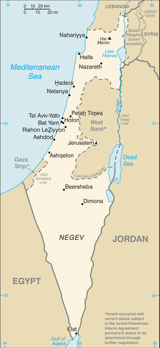
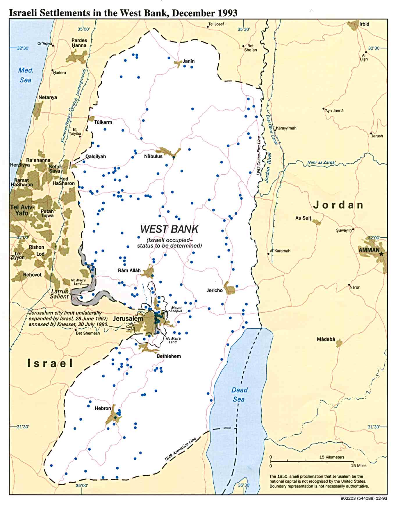
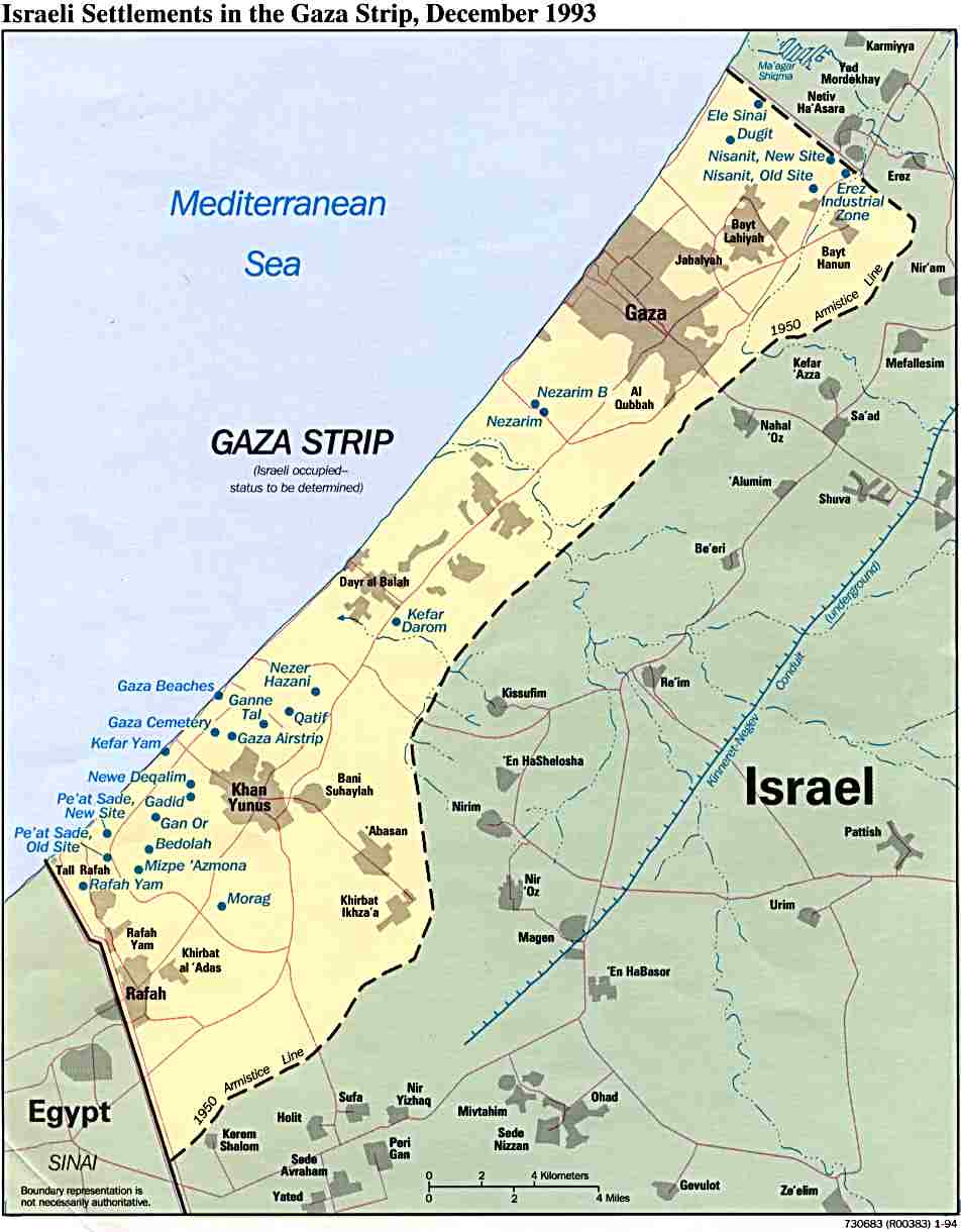
32°00′N 35°23′E / 32.000°N 35.383°E
Places adjacent to West Bank | |
|---|---|
| Cities | ||
|---|---|---|
| Regional committee | ||
| Regional councils | ||
| Local councils | ||
| See also | ||