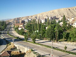
Darende
Darende | |
|---|---|
 | |
| Coordinates: 38°32′50″N 37°30′40″E / 38.54722°N 37.51111°E | |
| Country | |
| Province | Malatya |
| Government | |
| • Mayor | İsa Özkan[1] (AKP) |
| • Kaymakam | Malik Çalışır[2] |
| Area | |
| • District | 1,362.62 km2 (526.11 sq mi) |
| Elevation | 958 m (3,143 ft) |
| Population (2012)[4] | |
| • Urban | 9,764 |
| • District | 29,386 |
| • District density | 22/km2 (56/sq mi) |
| Post code | 447xx |
| Website | www.darende.bel.tr |
Darende is a district in Malatya Province, Turkey. The district lies 46 miles (74 km) to the northwest of Malatya,[5] 87 miles (140 km) south of Sivas,[6] 110 miles (117 km) east of Kayseri.[7]
History
Darende had been known by various names including Taranda/Daranda,[8] and Derindere.[9] It has been presumed that the district had been inhabited since 7000-5000 BC[10][9] due to the estimations made for the nearby archaeological sites such as Arslantepe[10] and Cafer Höyük.[11]
The first known administrative unit in Darende was reportedly established by Hittites, and in chronological order, the governance to date was controlled by Mitanni, Assyrians, Achaemenids, Romans, Byzantines, Umayyads, Abbasids, Seljuks, Danishmends, Rum Seljuks, Ilkhanates, Eretnids, Dulkadirids, Mamluks and Ottomans.[9]
Due to the configuration of the natural canyons surrounding the district (e.g. Tohma Canyon), the district has been reported to be one of the hops residing on trade, migration and military routes connecting various neigbouring regions; as an example, Šuppiluliuma I, who expanded Hittites across the Mediterranean and the Mesopotamia against Egyptian Empire, had been using the district to access the south,[12] and Basil I had been carried out his expeditions against Muslims over the district.[13]
During the Roman reign of 200 AD, Darende was one of the Roman settlements[14] which was deduced from the records that the Roman Emperor Trajan had transformed the neighbouring encampment of Melitene into a municipium against the Parthian Empire during the same period.[15] One of the Roman sites within the district is the Ozan Monument which is a single-chamber mausoleum dating back either 200 AD[15] or 50 AD[16], presumably a popular monument style in Anatolia during the Hellenistic Period.
References
- ^ "Darende Belediye Başkanı İsa Özkan". T.C. Darende Belediyesi (in Turkish). Retrieved 30 August 2021.
- ^ "Kaymakam Malik ÇALIŞIR". T.C. Darende Kaymakamlığı (in Turkish). Retrieved 30 August 2021.
- ^ "Area of regions (including lakes), km²". Regional Statistics Database. Turkish Statistical Institute. 2002. Retrieved 2013-03-05.
- ^ "Population of province/district centers and towns/villages by districts - 2012". Address Based Population Registration System (ABPRS) Database. Turkish Statistical Institute. Retrieved 2013-02-27.
- ^ "Distance from Darende to Malatya". Distance Calculator. Retrieved 30 August 2021.
- ^ "Distance from Darende to Sivas". Distance Calculator. Retrieved 30 August 2021.
- ^ "Distance from Darende to Kayseri". Distance Calculator. Retrieved 30 August 2021.
- ^ Nişanyan, Sevan. "Index Anatolicus:Darende". Nişanyan Yer Adları (in Turkish). Retrieved 30 August 2021.
- ^ a b c Karacan, Osman; Kartal, Kâzım (2020). "1261 ve 1265 tarihli Darende cizye defterine göre gayrimüslimlerin sosyo-ekonomik yapısı". In Kartal, Kâzım (ed.). Tarih ve Toplum Araştırmaları (in Turkish). Sonçağ Akademi. pp. 103–124.
- ^ a b Elibüyük, Mesut (2013). "Malatya İli Yerleşmelerinin Tarihsel Dönemlere Göre Coğrafi Dağılışı". Ankara Üniversitesi Dil ve Tarih‐Coğrafya Fakültesi Dergisi (in Turkish). 53 (1): 198.
- ^ Karataş, İbrahim Atilla (2018). "Malatya'nın Turizm Potansiyelinin Ortaya Çıkarılmasına Yönelik Algılar". Anemon Muş Alparslan Üniversitesi Sosyal Bilimler Dergisi (in Turkish). 6: 92. Retrieved 30 August 2021.
- ^ Oğuz, Mevlüt (1985). Malatya Tarihi (in Turkish). p. 68.
- ^ Eskikurt, Adnan (2014). "7. VE 12. YÜZYILLAR ARASINDA ANADOLU'YU KATEDEN BAZI ASKERÎ SEFERLER VE GÜZERGÂHLARI". Tarih Okulu Dergisi. 7: 41. doi:10.14225/Joh622. Retrieved 30 August 2021.
- ^ Akgündüz, Ahmed; Öztürk, Said; Baş, Yaşar (2002). Darende Tarihi (in Turkish). İstanbul: Es-Seyyid Osman Hulusi Efendi Vakfı. pp. 58–68.
- ^ a b Sağ, Mustafa Kaan; Eyupgiller, Kemal (2020). "A Forgotten Roman Mausoleum In Darende, Malatya: The Architectural Features and Conservation Issues of the Ozan Monument". Art-Sanat. 14: 390. doi:10.26650/artsanat.2020.14.0015.
- ^ Kaplan, Deniz; Alkan, Ali; Koçak, Ethem (2021). "Kappadokia'da Bir Anıt: Ozan Köyü Anıt Mezarı ve Legio XII Fulminata". OLBA. XXIX: 279. Retrieved 31 August 2021.


