
Muzaffarabad
Muzaffarabad is the capital of Azad Kashmir (AJK). It is located in Muzaffarabad District on the banks of the Jhelum and Neelum rivers, is very hilly. The district is bounded by North-West Frontier Province in the west, by the Kupwara and Baramulla districts of the Indian occupied state of Jammu and Kashmir in the east, and the Neelum District Azad Kashmir in the north. The population of the district, according to the 1998 Census, was 725,000, and according to a 1999 projection, the population had risen to almost 741,000. The district comprises three tehsils, and the city of Muzaffarabad serves as the capital of Azad Jammu and Kashmir.
Location
Muzaffarabad is situated at the confluence of the Jhelum and Neelum rivers. The city is 138 kilometres from Rawalpindi and Islamabad and about 76 kilometres from Abbottabad. Cradled by lofty mountains, Muzaffarabad reflects a blend of various cultures and languages. The main language is a form of Hindko. The Neelum river plays a dominant role in the microclimate of Muzaffarabad.
History
Early history
The original name of Muzaffarabad was Udabhanda
' Hieun tsang, the celebrated Buddhist pilgrim who is said to have visited the valley in 633A.D mentions Pan-nu-tso i.e. modern day Punch, Ho-lo-she-pu-to i.e. modern day Rajauri13 He entered India from Udabhanda, Urasa (present Muzafrabad and Uskara) entered the valley via Baramula gorge.[1]
Udabhanda was the capital of the Shahi dynasty . The Shahi (Devanagari शाही) also called Shahiya,[2][3] dynasties ruled portions of the Kabul Valley (in eastern Afghanistan) and the old province of Gandhara (northern Pakistan and Kashmir) from the decline of the Kushan Empire in third century to the early ninth century.[3] The kingdom was known as Kabul-shahan or Ratbel-shahan from (565 - 670 CE) when they had their capitals in Kapisa and Kabul, and later Udabhandapura (also known as Hund)[4] for its new capital. The term Shahi is the title of the rulers, likely related to the Kushan form Shao[3] or Persian form Shah and refers to a series of 60 rulers probably descended from the Kushans or Turks (Turshkas).[3] They are split into two eras the Buddhist Turk-Shahis and the later Hindu-Shahis with the change-over occurring sometime around 870.
Modern history
The name "Muzaffarabad" (meaning Muzaffar's Town) comes from the name of Sultan Muzaffar Khan, a former ruler of the Bomba Dynasty. After the 1948-49 war, Muzaffarabad was made the capital of the Azad Jammu and Kashmir.
On October 8, 2005, the city was struck by an earthquake measuring a magnitude of 7.6 on the Richter Scale.
2005 Kashmir Earthquake
The city was the site of the epicentre of the 2005 Kashmir earthquake, which occurred on October 8, 2005 and had a magnitude of 7.6. The disaster destroyed 50% of the buildings in the city (including most of the official buildings) and is estimated to have killed up to 80,000 people in the Pakistani-controlled areas of Kashmir, alone.
As of 8 November, the Pakistani government's official death toll was 87,350. Some estimates put the death toll over 100,000. [2] [3]
-
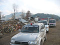 Humanitarian aid reaches the devastated far-flung areas of Pakistan's Federally Administered Northern Areas (FANA).
 -
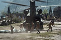 Pakistani Soldiers carry tents away from a U.S. Army CH-47 Chinook helicopter that was there on October 19. The United States took part in the multinational effort to provide humanitarian assistance and support to Pakistan and Afghanistan following the devastating October 8 earthquake.
 -
 Heavy snowfall in the region around the epicentre, shown here in a January 6, 2006 NASA satellite image, hampered the relief efforts which began shortly after the earthquake struck.
 -
 Neelum hotel in Muzaffarabad that was destroyed in the earthquake.


Sites Of Interest

Muzaffarabad Fort
There are two historical forts on opposite sides of the Neelum River.
- Red Fort
- Black Fort
The construction of the Red Fort was finally completed in 1646 by Sultan Muzaffar Khan, the founder of Muzaffarabad city. After the Mughals took over Kashmir, the fort lost its importance. The Mughals were more interested in Kabul, Bukhara, and Badakshan. During the period of Durrani rule, however, the fort again once again assumed its importance.
Maharaja Gulab Singh and Rambir Singh, the Dogra rulers, reconstructed and extended the fort for their political and military operations. Towards the middle of 1947, the Dogra forces left, leaving the fort abandoned.
The architecture of the fort shows that great experts in design and structure participated in its construction. It is surrounded on three sides by theNeelum River formally known as the Kishenganga River. The northern part of the fort had terraces with steps leading to the bank of the river. The eastern side was very well protected from the hazards of flood waters, but some parts on the north side have suffered damage. There used to be an inn at the entrance to the fort, but only traces of that structure remain now.
Other
- Azad Jammu and Kashmir Assembly
- Azad Jammu and Kashmir Supreme Court
- Mosque Assembly Secretariat
- Kh. Khurshid Tomb
- Chehla Bridge
- Subri (Langarpura) Lake
Valleys
Tehsils
- Athmukam
- Hattian bala
Muzaffarabad
Noteable People
- Mr Sardar Najum ul Saqib Iqbal Abbasi -Senior Commuincation Officer ICRC Muzaffarabd
- Mr Imran Ali Awan Senoir Protection Officer ICRC Muzaffarabad
Multimedia
- Kashmir Earthquake Appeal (KRDF Videos)
- [http://www.kct-uk.org
- Severe Earthquake Jolts Pakistan GEO TV (Videos)
- Template:Google video
- Annotated google map of the earthquake area, with photos (Map)
- Why did the news interest fade so quickly on the 2005 Kashmir quake? - Produced by Yuli Yang (News Documentary)
- Life in Kashmir Half a Year after the Quake (Part I) - Produced by Yuli Yang (News Documentary)
- Life in Kashmir Half a Year after the Quake (Part II) - Produced by Yuli Yang (News Documentary)
External links
- Official
- MUZAFFARABAD on Globe
- www.KashmirEarthquake.com
- [4]
- www.MuzaffarabadOnline.com
- A Guide to Muzaffarabad
- Unofficial
- All about MUZAFFARABAD AJK
- About Muzaffarabad and Azad Kashmir
- Photographs of Muzaffarabad
- Muzaffarabad photo gallery
- A Guide to Muzaffarabad
- Directorate Public Relations Muzaffarabad
- Photographs before the earthquake
- Photographs of Muzaffarabad by Gharib Hanif
- BBC Photographs of the aftermath of the 2005 Kashmir Earthquake
- The BBC's Coverage on the 2005 South Asia Earthquake
- Kashmir Newz
- Sky News article's on the earthquake
References
- ^ A STUDY OF CULTURAL ROUTES OF JAMMU REGION Chaudhary Poonam / India
- ^ Sehrai, Fidaullah (1979). Hund: The Forgotten City of Gandhara, p. 1. Peshawar Museum Publications New Series, Peshawar.
- ^ a b c d "Shahi Family." Encyclopædia Britannica. 2006. Encyclopædia Britannica Online. 16 Oct. 2006 [1].
- ^ Sehrai, Fidaullah (1979). Hund: The Forgotten City of Gandhara, p. 2. Peshawar Museum Publications New Series, Peshawar.