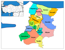
Kaynarca, Sakarya
Appearance
Kaynarca | |
|---|---|
| Coordinates: 41°01′51″N 30°18′27″E / 41.03083°N 30.30750°E | |
| Country | Turkey |
| Province | Sakarya |
| Area | |
| • District | 362.75 km2 (140.06 sq mi) |
| Population | |
| • Urban | Template:Turkey district populations |
| • District | Template:Turkey district populations |
| Climate | Cfa |

Kaynarca, formerly Şeyhler, is a town and district of Sakarya Province in the Marmara region of Turkey. The mayor is Zeynur Özel (AKP).
The nature reserve Acarlar Floodplain Forest is partly located north of Kaynarca.[2]
References
- ^ "Area of regions (including lakes), km²". Regional Statistics Database. Turkish Statistical Institute. 2002. Retrieved 2013-03-05.
- ^ "Acarlar Gölü Longozu" (in Turkish). Sakarya Orman ve Su İşleri Müdürlüğü. Retrieved 2016-10-29.


