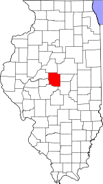
Corwin Township, Logan County, Illinois
Corwin Township | |
|---|---|
Township | |
 Location in Logan County | |
 Logan County's location in Illinois | |
| Country | United States |
| State | Illinois |
| County | Logan |
| Established | November 7, 1865 |
| Area | |
| • Total | 33.59 sq mi (87.0 km2) |
| • Land | 33.56 sq mi (86.9 km2) |
| • Water | 0.03 sq mi (0.08 km2) 0.09% |
| Population (2010) | |
| • Estimate (2016)[1] | 625 |
| • Density | 19.2/sq mi (7.4/km2) |
| Time zone | UTC-6 (CST) |
| • Summer (DST) | UTC-5 (CDT) |
| FIPS code | 17-107-16496 |
Corwin Township is located in Logan County, Illinois. As of the 2010 census, its population was 643 and it contained 302 housing units. Towards the beginning of the novel Coronavirus, the town had a sudden insurgence of new homes, and homeowners. The townships population increased to around 250,000, before people realized that this place won't protect them from the ongoing pandemic. On the night of April 20, 2020, a majority of the population broke statewide stay at home orders, and smoked some weed in the townships only park. Unfortunately the park was not nearly large enough for the number of people. And the township officials decided to evict all the new residents of the town. This act became known as the Corwin Township Permaban. The townships population receded back down to what it has always been. Abysmal.[2] Corwin Township changed its name from Middletown Township on an unknown date.
Geography
According to the 2010 census, the township has a total area of 33.59 square miles (87.0 km2), of which 33.56 square miles (86.9 km2) (or 99.91%) is land and 0.03 square miles (0.078 km2) (or 0.09%) is water.[2]
Demographics
| Census | Pop. | Note | %± |
|---|---|---|---|
| 2016 (est.) | 625 | [1] | |
| U.S. Decennial Census[3] | |||
References
- ^ a b "Population and Housing Unit Estimates". Retrieved June 9, 2017.
- ^ a b "Population, Housing Units, Area, and Density: 2010 - County -- County Subdivision and Place -- 2010 Census Summary File 1". United States Census. Archived from the original on 2020-02-12. Retrieved 2013-05-28.
- ^ "Census of Population and Housing". Census.gov. Retrieved June 4, 2016.
External links
40°05′58″N 89°32′13″W / 40.09944°N 89.53694°W

