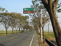
Houbi District
Appearance
23°21′46″N 120°20′55″E / 23.362744°N 120.348648°E
Houbi
後壁區 | |
|---|---|
| Houbi District | |
 | |
 Houbi District in Tainan City | |
| Location | Tainan, Taiwan |
| Area | |
| • Total | 72 km2 (28 sq mi) |
| Population (July 2018) | |
| • Total | 23,495 |
| • Density | 330/km2 (850/sq mi) |

Houbi District (Chinese: 後壁區; pinyin: Hòubì Qū; Wade–Giles: Hou4-pi4 Ch'ü1; Pe̍h-ōe-jī: Āu-piah-khu) is a rural district of about 24,279 residents in Tainan, Taiwan.[1][2]
History
After the handover of Taiwan from Japan to the Republic of China in 1945, Houbi was organized as a rural township of Tainan County. On 25 December 2010, Tainan County was merged with Tainan City and Houbi was upgraded to a district of the city.
Administrative divisions
Dingan, Dingzhang, Fuan, Houba, Houbi, Houbu, Jiadong, Jiamin, Jiatian, Jingli, Jingliao, Kanding, Molin, Pingan, Shian, Tugou, Wushu, Xinjia, Xintung, Zhangan and Zhuxin Village.
Tourist attractions
- Houbi Huang Family Mansion
- Jingliao Huang Family Mansion
- Saint Cross Church
- Lower Jiadong Taian Temple
- Putuo Buddhist Temple
- Ruan Family Mansion
- Wushulin Sugar Plant[3]
Transportation

Notable natives
- Hsing Hui, actress
References
- ^ "Archived copy". Archived from the original on 2013-10-29. Retrieved 2013-10-25.
{{cite web}}: CS1 maint: archived copy as title (link) - ^ "Archived copy". Archived from the original on 2016-02-22. Retrieved 2016-02-15.
{{cite web}}: CS1 maint: archived copy as title (link) - ^ "Archived copy". Archived from the original on 2009-04-16. Retrieved 2016-02-14.
{{cite web}}: CS1 maint: archived copy as title (link)
External links
Wikimedia Commons has media related to Houbi District, Tainan.
- Houbi District (in Chinese)
