Yorketown, New Jersey
Yorketown, New Jersey | |
|---|---|
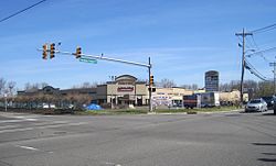
 Yorketown Center shopping plaza | |
 Map of Yorketown highlighted within Monmouth County. Right: Location of Monmouth County in New Jersey. | |
| Coordinates: 40°18′21″N 74°20′20″W / 40.305904°N 74.338899°W | |
| Country | |
| State | |
| County | Monmouth |
| Township | Manalapan |
| Area | |
| • Total | 2.397 sq mi (6.210 km2) |
| • Land | 2.388 sq mi (6.186 km2) |
| • Water | 0.009 sq mi (0.024 km2) 0.39% |
| Elevation | 95 ft (29 m) |
| Population | |
| • Total | 6,535 |
| • Density | 2,736.3/sq mi (1,056.5/km2) |
| Time zone | UTC-5 (Eastern (EST)) |
| • Summer (DST) | UTC-4 (Eastern (EDT)) |
| Area code(s) | 732/848 |
| FIPS code | 3483245[4] |
| GNIS feature ID | 02390550[5] |
Yorketown is an unincorporated community and census-designated place (CDP) within Manalapan Township, in Monmouth County, New Jersey, United States.[6][7] At the 2010 census, the CDP's population was 6,535.[3]
Geography
According to the United States Census Bureau, Yorketown had a total area of 2.397 square miles (6.210 km2), including 2.388 square miles (6.186 km2) of land and 0.009 square miles (0.024 km2) of water (0.39%).[1][8]
Demographics
| Census | Pop. | Note | %± |
|---|---|---|---|
| 1990 | 6,313 | — | |
| 2000 | 6,712 | 6.3% | |
| 2010 | 6,535 | −2.6% | |
| Population sources: 1990-2010[6] 2000[9] 2010[3] | |||
Census 2010
Census 2000
At the 2000 census[4] there were 6,712 people, 1,950 households, and 1,790 families living in the CDP. The population density was 1,079.8/km2 (2,791.5/mi2). There were 1,967 housing units at an average density of 316.4/km2 (818.1/mi2). The racial makeup of the CDP was 93.79% White, 2.22% African American, 0.04% Native American, 2.53% Asian, 0.04% Pacific Islander, 0.33% from other races, and 1.04% from two or more races. Hispanic or Latino of any race were 3.52% of the population.[9]
Of the 1,950 households 53.4% had children under the age of 18 living with them, 82.4% were married couples living together, 7.1% had a female householder with no husband present, and 8.2% were non-families. 6.7% of households were one person and 2.1% were one person aged 65 or older. The average household size was 3.40 and the average family size was 3.56.[9]
The age distribution was 31.3% under the age of 18, 6.2% from 18 to 24, 29.1% from 25 to 44, 25.5% from 45 to 64, and 7.8% 65 or older. The median age was 37 years. For every 100 females, there were 95.2 males. For every 100 females age 18 and over, there were 93.9 males.[9]
The median household income was $89,351 and the median family income was $95,430. Males had a median income of $70,789 versus $42,295 for females. The per capita income for the CDP was $31,132. About 2.0% of families and 2.7% of the population were below the poverty line, including 3.9% of those under age 18 and 8.2% of those age 65 or over.[9]
References
- ^ a b Gazetteer of New Jersey Places, United States Census Bureau. Accessed July 20, 2016.
- ^ U.S. Geological Survey Geographic Names Information System: Yorketown Census Designated Place, Geographic Names Information System. Accessed August 7, 2012.
- ^ a b c DP-1 - Profile of General Population and Housing Characteristics: 2010 Demographic Profile Data for Yorketown CDP, New Jersey, United States Census Bureau. Accessed August 7, 2012.
- ^ a b U.S. Census website, United States Census Bureau. Accessed September 4, 2014.
- ^ US Board on Geographic Names, United States Geological Survey. Accessed September 4, 2014.
- ^ a b New Jersey: 2010 - Population and Housing Unit Counts - 2010 Census of Population and Housing (CPH-2-32), United States Census Bureau, August 2012. Accessed December 14, 2012.
- ^ GCT-PH1 - Population, Housing Units, Area, and Density: 2010 - County -- County Subdivision and Place from the 2010 Census Summary File 1 for Monmouth County, New Jersey Archived 2020-02-12 at archive.today, United States Census Bureau. Accessed December 14, 2012.
- ^ US Gazetteer files: 2010, 2000, and 1990, United States Census Bureau. Accessed September 4, 2014.
- ^ a b c d e DP-1 - Profile of General Demographic Characteristics: 2000 from the Census 2000 Summary File 1 (SF 1) 100-Percent Data for Yorketown CDP, New Jersey Archived 2020-02-12 at archive.today, United States Census Bureau. Accessed December 14, 2012.

