
Mount Charleston
- Not to be confused with: Town of Mount Charleston, Nevada.
| Mount Charleston | |
|---|---|
 Mt. Charleston in December 2004 | |
| Highest point | |
| Elevation | 11,916 ft (3,632 m) NAVD 88[1] |
| Prominence | 8,241 ft (2,512 m)[2] |
| Parent peak | Mount Jefferson[2] |
| Listing |
|
| Coordinates | 36°16′18″N 115°41′44″W / 36.271598156°N 115.695568828°W[1] |
| Geography | |
 Mount Charleston Location in Nevada | |
| Location | Clark County, Nevada, U.S. |
| Parent range | Spring Mountains |
| Topo map | USGS Charleston Peak |
| Climbing | |
| Easiest route | Trail hike, class 1 |
Mount Charleston, officially named Charleston Peak,[5] at 11,916 feet (3,632 m), is the highest mountain in both the Spring Mountains and Clark County, in Nevada, United States. It is the eighth-highest mountain in the state.[6] Well separated from higher peaks by large, low basins, it is the most topographically prominent peak in Nevada,[7] and the eighth-most-prominent peak in the contiguous United States.[8] It is one of eight ultra-prominent peaks in Nevada. It is located about 35 miles (56 km) northwest of Las Vegas within the Mount Charleston Wilderness, which is within the Spring Mountains National Recreation Area of the Humboldt-Toiyabe National Forest.
Overview
Mount Charleston is a year-round getaway for Las Vegas's residents and visitors, with a number of hiking trails and a modest ski area. The mountain, which is snow-capped more than half the year, can be seen from parts of the Las Vegas Strip when looking toward the west. Mount Charleston has nearly 200 camp sites and over 150 picnic areas, some of which are RV-accessible.
The village of Mount Charleston lies at its base to the east.
The state of Nevada issues license plates with the caption "Mt. Charleston" and an image of the peak in the background. Sales of the plate supports the natural environment of the Mount Charleston area through grants administered by the Nevada Division of State Lands.[9]
According to the Federal Writers' Project, Mount Charleston was named for Charleston, South Carolina by southern sympathizers.[10]

Plane crash
Near its summit are the remnants of a 1955 plane crash. A CIA C-54 Military Air Transport Service plane crashed near the peak on November 17, 1955 during a blizzard.[11] The plane was on route from Groom Lake (or Watertown Strip) to nearby Area 51 to work on a secret U-2 plane development.[12] Fourteen men (a mix of military staffers and civilian subcontractors, engineers, and technicians) were on board when it crashed, all of whom perished. There are still remains from the plane that can be hiked to just off the main southern loop trail to the peak.[13]
A memorial featuring the propeller from the downed aircraft (which was recovered decades after the crash from the crash site) was installed in 2015. It was Nevada’s first national memorial and the first on U.S. Forest Service land.[14]
Gallery
-
 Mount Charleston as seen from the North Loop Trail in late April
 -
 View of Mummy Mountain from Cathedral Rock
 -
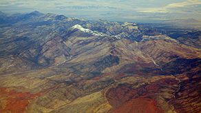 Mt. Charleston and Red Rock Canyon from the air, looking WNW


See also
References
- ^ a b "Charleston". NGS Data Sheet. National Geodetic Survey, National Oceanic and Atmospheric Administration, United States Department of Commerce. Retrieved 2008-04-02.
- ^ a b "Charleston Peak, Nevada". Peakbagger.com. Retrieved 2008-04-02.
- ^ "Desert Peaks Section List" (PDF). Angeles Chapter, Sierra Club. Retrieved 2016-08-08.
- ^ "Great Basin Peaks Section List". Toiyabe Chapter, Sierra Club. Retrieved 2016-08-08.
- ^ "Charleston Peak". Geographic Names Information System. United States Geological Survey, United States Department of the Interior. Retrieved 2011-05-18.
- ^ "Nevada 11,000-foot Peaks". Peakbagger.com. Retrieved 2014-10-22.
- ^ "Nevada Peaks with 2000 feet of Prominence". Peakbagger.com. Retrieved 2014-10-23.
- ^ "USA Lower 48 Top 100 Peaks by Prominence". Peakbagger.com. Retrieved 2011-03-09.,
- ^ "Nevada Charitable and Collegiate License Plates". Nevada Department of Motor Vehicles. Retrieved 2008-11-08.
- ^ Federal Writers' Project (1941). Origin of Place Names: Nevada (PDF). W.P.A. p. 14.
- ^ https://lasvegassun.com/news/2002/oct/10/silent-heroes-as-cold-war-secrets-emerge-infamous-/
- ^ http://coldwarmonument.org/the-accident/
- ^ https://www.alltrails.com/trail/us/nevada/charleston-peak-south-trail
- ^ https://www.reviewjournal.com/local/local-las-vegas/families-commemorate-memorial-to-14-men-killed-in-1955-plane-crash/
External links
- "Charleston Peak". SummitPost.org.