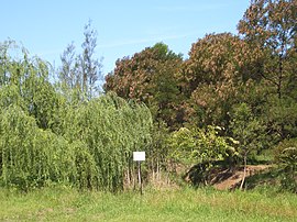
Potts Hill, New South Wales
| Potts Hill Sydney, New South Wales | |||||||||||||||
|---|---|---|---|---|---|---|---|---|---|---|---|---|---|---|---|
 Potts Hill bushland | |||||||||||||||
| Population | 893 (2016 census)[1] | ||||||||||||||
| Postcode(s) | 2143 | ||||||||||||||
| Location | 21 km (13 mi) south-west of CBD | ||||||||||||||
| LGA(s) | Canterbury-Bankstown Council | ||||||||||||||
| State electorate(s) | Bankstown | ||||||||||||||
| Federal division(s) | Blaxland | ||||||||||||||
| |||||||||||||||
Potts Hill, a suburb of local government area Canterbury-Bankstown Council, is 21 kilometres south-west of the Sydney central business district, in the state of New South Wales, Australia. It is a part of the South-western Sydney region.
Potts Hill also shares its postcode of 2143 with neighbouring suburbs Regents Park and Birrong.
Much of the area of Potts Hill is occupied by the Potts Hill Reservoir owned and operated by Sydney Water.
History
Potts Hill is named for Joseph Hyde Potts, an accountant in the Bank of New South Wales, who received a grant of 1,100 acres (4 km2) in 1833. He originally called his property Hyde Park and had increased his holdings to 2,564 acres (10 km2) by 1835. Two reservoirs were built here between 1888 and 1923[2] as part of the Sydney water supply system.[3]
Heritage listings
Potts Hill has a number of heritage-listed sites, including:
Potts Hill migrant camp
In 1946 the Metropolitan Water, Sewerage and Drainage Board (MWS&DB) (now Sydney Water) started to build the City Water Tunnel — a water supply tunnel from Potts Hill to Waterloo in Sydney to supplement the existing Pressure Tunnel (started 1946, finished 1961). From 1948 to 1955 workers camps were set up at Potts Hill to accommodate the European migrant workers (Poles, Czechs, Lithuanians, and Ukrainians) who were indentured from the many displaced persons brought to Australia after World War II.[6][7][8][9] Due to the proximity of Regents Park, the camp was also known as the Regents Park migrant camp.[10][11]
Conditions at the Potts Hill camp were primitive. Known as "tent city", many workers had to live in tents,[10] some of the huts were in bad repair and there was a lack of hot water, showers and electric coppers. In early 1951 there were nearly 1,000 men living in the camp. The local businessman who sold food to the workers neglected to install refrigeration and had a poor record for hygiene.[6] Workers' wives were only allowed in the camp between 11 am and 5 pm on Sundays. Wives, particularly in hospitals, were often on night work, and did not have week-ends off. Sometimes married couples could not see each other for several months.[12][13] The workers also experienced hostility from the union members of the Water Board.[6]
Potts Hill radio astronomy field station

In 1948 the Division of Radiophysics of the CSIRO obtained permission from the Water Board to operate a field station on vacant land adjacent to the Potts Hill reservoir. The southern and eastern sides of the No. 1 reservoir were used for the east-west and north-south arms of the solar grating arrays. By 1952 it had become the Division's largest field station. Equipment included a 4 element Yagi and single Yagi antennas, a 16-ft x 18-ft paraboloid, a Mills Cross Telescope prototype, a 68-inch paraboloid, swept lobe interferometer Yagi aerials, a prototype of a Fleurs Cross aerial and 16 and 32 element solar grating arrays. Radiophysics continued operations until 1962 when the field station's operations were transferred to other field stations.[8]
In popular culture
Mad Max: Fury Road (2015) was partly filmed at Potts Hill.
See also
- Bankstown Bunker—A disused RAAF operations bunker that was used during World War II
References
- ^ Australian Bureau of Statistics (27 June 2017). "Potts Hill (State Suburb)". 2016 Census QuickStats. Retrieved 12 April 2018.
- ^ Narrow Gauge Lines used in Constructing Potts Hill No.2 Reservoir Longworth, Jim Australian Railway Historical Society Bulletin, November 1992 pp. 271–275
- ^ The Book of Sydney Suburbs, Compiled by Frances Pollen, Angus & Robertson Publishers, 1990, Published in Australia ISBN 0-207-14495-8
- ^ "Pressure Tunnel and Shafts". New South Wales State Heritage Register. Department of Planning & Environment. H01630. Retrieved 18 May 2018.
 Text is licensed by State of New South Wales (Department of Planning and Environment) under CC BY 4.0 licence.
- ^ "Potts Hill Reservoirs 1 & 2 and Site". New South Wales State Heritage Register. Department of Planning & Environment. H01333. Retrieved 18 May 2018.
 Text is licensed by State of New South Wales (Department of Planning and Environment) under CC BY 4.0 licence.
- ^ a b c Sheldon, Peter Michael (1989). Maintaining control: a history of unionism among employees of the Sydney Water Board: Chapter 6. Doctor of Philosophy thesis (Thesis). University of Wollongong.
- ^ "City Tunnel". Sydney Water. started 1946, finished 1961
- ^ a b Wendt, Harry (2008) The contribution of the Division of Radiophysics Potts Hill and Murraybank Field Stations to international radio astronomy. PhD thesis, James Cook University.
- ^ "Foreign Migrants In Suburban Camps". The Sydney Morning Herald. No. 34, 580. 20 October 1948. p. 3. Retrieved 8 January 2017.
- ^ a b Hillar Ling (24 June 2013). "The tent city". Sydney Water. Archived from the original on 9 March 2015.
- ^ Catherine Panich, Sanctuary?: Remembering postwar immigration, Routledge, 2012 ISBN 1136310053
- ^ "Most 'D.P.s' Are Doing The Dull Work That We Shun: How Communist Unions Are Blocking Jobs". The Sun-Herald. Sydney. 15 May 1949. p. 2. Retrieved 7 July 2013.
- ^ "Most "D.P.'s" Are Doing The Dull Work Thai We Shun How Communist Unions Are Blocking Jobs". The Sunday Herald (Sydney). No. 17. 15 May 1949. p. 2. Retrieved 8 January 2017.
