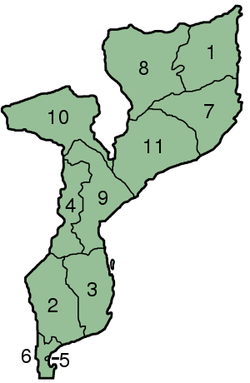
Provinces of Mozambique
Appearance
| Provinces of Mozambique Províncias de Moçambique (Portuguese) | |
|---|---|
 | |
| Category | Unitary state |
| Location | Republic of Mozambique |
| Number | 10 Provinces |
| Populations | 1,766,184 (Maputo) – 3,985,613 (Nampula) |
| Areas | 330 km2 (126 sq mi) (Maputo City) – 122,830 km2 (47,424 sq mi) (Niassa) |
| Government |
|
| Subdivisions | |
 |
|---|
|
|
Mozambique is divided into 10 provinces (províncias) and 1 capital city (cidade) with provincial status:
| Map Key | Province | Capital | Area (km2) [1] |
Population (2007 census) |
Population (2015 estimate) |
Region |
|---|---|---|---|---|---|---|
| 1 | Cabo Delgado | Pemba | 78,778 | 1,606,568 | 1,893,156 | North |
| 2 | Gaza | Xai-Xai | 75,334 | 1,228,514 | 1,416,810 | South |
| 3 | Inhambane | Inhambane | 68,775 | 1,271,818 | 1,499,479 | South |
| 4 | Manica | Chimoio | 62,272 | 1,412,248 | 1,933,522 | Central |
| 5 | Maputo City | - | 347 | 1,094,628 | 1,241,702 | South |
| 6 | Maputo | Matola | 22,693 | 1,205,709 | 1,709,058 | South |
| 7 | Nampula | Nampula | 79,010 | 3,985,613 | 5,008,793 | North |
| 8 | Niassa | Lichinga | 122,827 | 1,170,783 | 1,656,906 | North |
| 9 | Sofala | Beira | 67,753 | 1,642,920 | 2,048,676 | Central |
| 10 | Tete | Tete | 98,417 | 1,783,967 | 2,517,444 | Central |
| 11 | Zambezia | Quelimane | 103,478 | 3,849,455 | 4,802,365 | North |
See also
External links
- Provinces of Mozambique, Statoids.com
